Related Research Articles
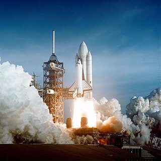
A communications satellite is an artificial satellite that relays and amplifies radio telecommunication signals via a transponder; it creates a communication channel between a source transmitter and a receiver at different locations on Earth. Communications satellites are used for television, telephone, radio, internet, and military applications. Many communications satellites are in geostationary orbit 22,300 miles (35,900 km) above the equator, so that the satellite appears stationary at the same point in the sky; therefore the satellite dish antennas of ground stations can be aimed permanently at that spot and do not have to move to track the satellite. Others form satellite constellations in low Earth orbit, where antennas on the ground have to follow the position of the satellites and switch between satellites frequently.

A communication channel refers either to a physical transmission medium such as a wire, or to a logical connection over a multiplexed medium such as a radio channel in telecommunications and computer networking. A channel is used for information transfer of, for example, a digital bit stream, from one or several senders to one or several receivers. A channel has a certain capacity for transmitting information, often measured by its bandwidth in Hz or its data rate in bits per second.

A very-small-aperture terminal (VSAT) is a two-way satellite ground station with a dish antenna that is smaller than 3.8 meters. The majority of VSAT antennas range from 75 cm to 1.2 m. Bit rates, in most cases, range from 4 kbit/s up to 16 Mbit/s. VSATs access satellites in geosynchronous orbit or geostationary orbit to relay data from small remote Earth stations (terminals) to other terminals or master Earth station "hubs".
The S band is a designation by the Institute of Electrical and Electronics Engineers (IEEE) for a part of the microwave band of the electromagnetic spectrum covering frequencies from 2 to 4 gigahertz (GHz). Thus it crosses the conventional boundary between the UHF and SHF bands at 3.0 GHz. The S band is used by airport surveillance radar for air traffic control, weather radar, surface ship radar, and some communications satellites, especially those satellites used by NASA to communicate with the Space Shuttle and the International Space Station. The 10 cm radar short-band ranges roughly from 1.55 to 5.2 GHz. The S band also contains the 2.4–2.483 GHz ISM band, widely used for low power unlicensed microwave devices such as cordless phones, wireless headphones (Bluetooth), wireless networking (WiFi), garage door openers, keyless vehicle locks, baby monitors as well as for medical diathermy machines and microwave ovens. India's regional satellite navigation network (IRNSS) broadcasts on 2.483778 to 2.500278 GHz.

A satellite telephone, satellite phone or satphone is a type of mobile phone that connects to other phones or the telephone network by radio link through satellites orbiting the Earth instead of terrestrial cell sites, as cellphones do. Therefore, they can work in most geographic locations on the Earth's surface, as long as open sky and the line-of-sight between the phone and the satellite are provided. Depending on the architecture of a particular system, coverage may include the entire Earth or only specific regions. Satellite phones provide similar functionality to terrestrial mobile telephones; voice calling, text messaging, and low-bandwidth Internet access are supported through most systems. The advantage of a satphone is that it can be used in such regions where local terrestrial communication infrastructures, such as landline and cellular networks, are not available.
Satellite Internet access or Satellite Broadband is Internet access provided through communication satellites. This technology enables users to access the Internet regardless of their geographical location. Modern consumer grade satellite Internet service is typically provided to individual users through geostationary satellites that can offer relatively high data speeds, with newer satellites using Ku band to achieve downstream data speeds up to 506 Mbit/s. In addition, new satellite internet constellations are being developed in low-earth orbit to enable low-latency internet access from space.

A satellite navigation or satnav system is a system that uses satellites to provide autonomous geopositioning. A satellite navigation system with global coverage is termed global navigation satellite system (GNSS). As of 2023, four global systems are operational: the United States' Global Positioning System (GPS), Russia's Global Navigation Satellite System (GLONASS), China's BeiDou Navigation Satellite System, and the European Union's Galileo.
THAICOM 4, also known as IPSTAR 1, is a high throughput satellite built by Space Systems/Loral (SS/L) for Thaicom Public Company Limited. It was launched on August 11, 2005, from the European Space Agency's spaceport in French Guiana on board the Ariane rocket. The satellite had a launch mass of 6486 kilograms and is from SS/L's LS-1300 series of spacecraft.
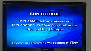
A Sun outage, Sun transit, or Sun fade is an interruption in or distortion of geostationary satellite signals caused by interference of the Sun when it falls directly behind a satellite which an Earth station is trying to receive data from or transmit data to. It usually occurs briefly to such satellites twice per year and such earth stations install temporary or permanent guards to their receiving systems to prevent equipment damage.

High Earth orbit (HEO) is a region of space around the Earth where satellites and other spacecraft are placed in orbits that are very high above the planet's atmosphere. This area is defined as an altitude higher than 35,786 km above sea level, which is the radius of a circular geosynchronous orbit. HEO extends to end of the Earth's sphere of influence. Satellites in HEO are primarily used for communication, navigation, scientific research, and military applications. A variety of satellites, such as TESS, have been placed in HEO.
The International Cospas-Sarsat Programme is a satellite-aided search and rescue (SAR) initiative. It is organized as a treaty-based, nonprofit, intergovernmental, humanitarian cooperative of 45 nations and agencies. It is dedicated to detecting and locating emergency locator radio beacons activated by persons, aircraft or vessels in distress, and forwarding this alert information to authorities that can take action for rescue. Member countries operate a constellation of around 66 satellites orbiting the Earth which carry radio receivers capable of locating an emergency beacon anywhere on Earth transmitting on the Cospas-Sarsat frequency of 406 MHz.

Commercial use of space is the provision of goods or services of commercial value by using equipment sent into Earth orbit or outer space. This phenomenon – aka Space Economy – is accelerating cross-sector innovation processes combining the most advanced space and digital technologies to develop a broad portfolio of space-based services. The use of space technologies and of the data they collect, combined with the most advanced enabling digital technologies is generating a multitude of business opportunities that include the development of new products and services all the way to the creation of new business models, and the reconfiguration of value networks and relationships between companies. If well leveraged such technology and business opportunities can contribute to the creation of tangible and intangible value, through new forms and sources of revenue, operating efficiency and the start of new projects leading to multidimensional positive impact. Examples of the commercial use of space include satellite navigation, satellite television and commercial satellite imagery. Operators of such services typically contract the manufacturing of satellites and their launch to private or public companies, which form an integral part of the space economy. Some commercial ventures have long-term plans to exploit natural resources originating outside Earth, for example asteroid mining. Space tourism, currently an exceptional activity, could also be an area of future growth, as new businesses strive to reduce the costs and risks of human spaceflight.
Terrain contour matching, or TERCOM, is a navigation system used primarily by cruise missiles. It uses a contour map of the terrain that is compared with measurements made during flight by an on-board radar altimeter. A TERCOM system considerably increases the accuracy of a missile compared with inertial navigation systems (INS). The increased accuracy allows a TERCOM-equipped missile to fly closer to obstacles and at generally lower altitudes, making it harder to detect by ground radar.

Satellite television is a service that delivers television programming to viewers by relaying it from a communications satellite orbiting the Earth directly to the viewer's location. The signals are received via an outdoor parabolic antenna commonly referred to as a satellite dish and a low-noise block downconverter.
DVB-RCS is an acronym for Digital Video Broadcasting - Return Channel via Satellite or. It is a specification for an interactive on-demand multimedia satellite communication system formulated in 1999 by the DVB consortium.

Advanced Extremely High Frequency (AEHF) is a constellation of communications satellites operated by the United States Space Force. They are used to relay secure communications for the United States Armed Forces, the British Armed Forces, the Canadian Armed Forces, the Netherlands Armed Forces and the Australian Defence Force. The system consists of six satellites in geostationary orbits. The final satellite was launched on 26 March 2020. AEHF is backward compatible with, and replaces, the older Milstar system and will operate at 44 GHz uplink and 20 GHz downlink. The AEHF system is a joint service communications system that provides survivable, global, secure, protected, and jam-resistant communications for high-priority military ground, sea and air assets.
Real-time geotagging refers to the automatic technique of acquiring media, associating a specific location with the media, transferring the media to an online map and publishing the media in real time. It is thus an extension of an automatic geotagging process, requiring an in-built or attached location acquisition device, but also requires communication with a wireless data transfer device. Most modern smartphones and several digital cameras already integrate camera, aGPS, and wireless data transfer into one device, thus directly producing a geotagged photograph. Real-time geotagging is sometimes referred to as "mobile geotagging" or "autogeotagging", but this does not imply the real-time publishing step.
Tooway satellite broadband Internet service available across Europe. The first version of the service was launched in 2007 via two Eutelsat geostationary satellites, Hot Bird 6 and Eurobird 3, respectively at the 13° and 33° East orbital positions.

Laser communication in space is the use of free-space optical communication in outer space. Communication may be fully in space or in a ground-to-satellite or satellite-to-ground application. The main advantage of using laser communications over radio waves is increased bandwidth, enabling the transfer of more data in less time.

A ground segment consists of all the ground-based elements of a space system used by operators and support personnel, as opposed to the space segment and user segment. The ground segment enables management of a spacecraft, and distribution of payload data and telemetry among interested parties on the ground. The primary elements of a ground segment are:
References
![]() This article incorporates public domain material from Federal Standard 1037C. General Services Administration. (in support of MIL-STD-188).
This article incorporates public domain material from Federal Standard 1037C. General Services Administration. (in support of MIL-STD-188).
| | This article related to telecommunications is a stub. You can help Wikipedia by expanding it. |