
The Varsity is a restaurant chain in Atlanta, Georgia. The main branch of the chain was the largest drive-in fast food restaurant in the world taking up two city blocks and can accommodate 800 diners. The main location ended car-side service in 2020. There are now six other branches across metropolitan Atlanta.

Five Points is a district of Atlanta, Georgia, United States, the primary reference for the downtown area.

The Fairlie–Poplar Historic District is part of the central business district in downtown Atlanta. It is named for the two streets that cross at its center, northeast-only Fairlie and southeast-only Poplar. Fairlie–Poplar is immediately north of Five Points, the definitive center point and longtime commercial heart of Atlanta. It is roughly bounded on the southwest by Marietta Street, on the southeast by Peachtree Street or Park Place, on the northeast by Luckie Street or Williams Street, and on the northwest by Cone Street or Spring Street. It has smaller city blocks than the rest of the city, and the streets run at a 40° diagonal.
The Kimball House was the name of two historical hotels in Atlanta, Georgia. United States. Both were constructed on an entire city block at the south-southeast corner of Five Points, bounded by Whitehall Street, Decatur Street, Pryor Street, and Wall Street, a block now occupied by a multi-story parking garage.

Located at 695 North Avenue in Atlanta, the Dupre Excelsior Mill may have been built as early as 1890 by DuPre Manufacturing Company. However, the mill fails to appear on Atlanta city maps in 1892 and 1899, which both show the property as vacant. The first possible reference to the mill exists in the report of the death of Hubert Neal on July 17, 1899. According to the report, his accident occurred at the Atlanta Excelsior Works, which may or may not be the same facility since at the time there were three excelsior factories in Atlanta. The earliest concrete confirmation of the mill seems to be three lawsuits filed against Dupre in 1907 for accidents that occurred at the facility. The mill does appear on the Sanborn-Perris fire insurance map of 1911. At that time, the only road connecting it was Angier Street. It was noted to have been heated by steam power, no lighting, and a private water supply from a well 10 feet in diameter and 40 feet deep. A watchman made hourly rounds to seven stations.
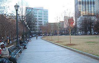
Woodruff Park, named for Robert W. Woodruff, is located in the heart of Downtown Atlanta, Georgia. The park's 6 acres (2.4 ha) are north of Edgewood Ave, between Peachtree Street NE and Park Place NE. The park includes a fountain, a performance pavilion, and several monuments.

America's Packard Museum is an automotive museum located in Dayton, Ohio.

South Downtown is a historic neighborhood of Downtown Atlanta, Georgia, United States. South Downtown is primarily home to city, county, state, and federal governmental offices, which prompted the city to adopt signage declaring the area "Government Walk." Although much of South Downtown is dominated by surface parking lots, the neighborhood was passed over during the redevelopment boom of the 1960s and 1970s that resulted in the demolition of much of Downtown's architecturally significant buildings. The result is myriad buildings from the 1950s and earlier that retain their historic structural integrity.
Hunter Hills is a neighborhood located west of downtown Atlanta, Georgia, United States. Its motto, "One Community, One Family", has been its cornerstone since 2001. The neighborhood is encompassed in the 30314 zip code. Hunter Hills shares borders with Mozley Park, Dixie Hills and West Lake neighborhoods. The neighborhood rests just inside Atlanta's perimeter highway I-285, and U.S. Route 78. The schools that serve the neighborhood are Stanton Elementary, Carter G. Woodson Elementary School, Ron Clark Academy, Herndon Elementary and Washington High School, and the Atlanta Job Corps. City of Refuge, a community-based 501(c)(3) non-profit, was established on the 1300 block of Joseph E. Boone Blvd. in 2003 and helps to bring transformation to individuals and families through services including housing, health and wellness, vocational training, and youth development.

Peachtree Presbyterian Church is a megachurch located in Atlanta, Georgia. Peachtree averages about 3200 in weekly worship at two venues on both sides of Roswell Road in the Buckhead region of Atlanta, and is one of the largest Presbyterian congregations in the United States of America.
Murrell's Row was a red-light district of Atlanta "starting at the juncture of Line, Decatur and Peachtree streets" (i.e. at today's Five Points "and running back towards Pryor on Decatur street". According to Archival Atlanta:
Named for the notorious Tennessee murderer, John A. Murrell, this section of town was a favorite hangout for thieves, gamblers, cutthroats, and prostitutes. Drunken brawls and cockfights were common and expected here. Before the Civil War, Murrell’s Row was the preferred meeting place for those who wanted to fight and concoct schemes. This notorious area north of Decatur Street between Peachtree and Pryor faded away shortly before the Civil War.
Lenox Park is a neighborhood of homes and office buildings located primarily within the city of Brookhaven, Georgia, just east of the northern border of the city of Atlanta.
The Atlanta Hotel also known as Thompson's Hotel, was one of the original hotels in antebellum Atlanta, Georgia. It stood at the northwest side of State Square, pre-war Atlanta's central square, on the northwest side of Pryor Street between Decatur Street and what is now Wall Street.

State Square was the central square of antebellum Atlanta, Georgia. The original Atlanta Union Depot designed by Edward A. Vincent stood in the middle of the square. The square was bounded by Marietta Street on the northeast, Pryor Street on the northwest, Loyd Street on the southeast, and Alabama Street on the south. The square was surrounded by Atlanta's most important buildings including the hotels Atlanta, Trout House, and Washington Hall, the Atlanta Bank, retail stores, and warehouses.

Atlanta's first Union Station, also known as Union Depot (1853–1864) was the original depot of Atlanta, Georgia. It was designed by architect Edward A. Vincent. It stood in the middle of State Square, the city's main square at the time, where Wall Street now is between Pryor Street and Central Avenue. It was destroyed in General Sherman's burning of the city during the Battle of Atlanta. Atlanta's 1871 Union Station was built on the site.

Atlanta's second Union Station was built in 1871 on the site of the 1853 station, burned in mid November 1864 when Federal forces left Atlanta for the March to the Sea. It was built in Second Empire style, designed by architect Max Corput. It was located at what is now Wall Street between Pryor Street and Central Avenue.

Washington–Rawson was a neighborhood of Atlanta, Georgia. It included what is now Center Parc Stadium and the large parking lot to its north, until 1997 the site of Atlanta–Fulton County Stadium, as well as the I-20-Downtown Connector interchange. Washington and Rawson streets intersected where the interchange is today. To the northwest was Downtown Atlanta, to the west Mechanicsville, to the east Summerhill, and to the south Washington Heights, now called Peoplestown.
The Trout House was one of three hotels in antebellum Atlanta, Georgia, along with the Atlanta Hotel and Washington Hall. It was built in 1849 by Jeremiah F. Trout. It was a four-story brick building at the southwest corner of Decatur and Pryor Streets, facing the union depot and State Square.

The Hotel Aragon was a six-story, 125-room hotel at 169 Peachtree Street NE, at the southeast corner of Ellis Street in Atlanta, in what is today the Peachtree Center area of downtown. It was a major addition to the city's hotel capacity at its completion in 1892, cost $250,000, and was built and owned by George Washington Collier. It was the only major hotel in the city not adjacent to Union Station. A 1902 guidebook describes the Aragon as one of three first-class hotels in the city, together with the Kimball House and the Majestic Hotel.

Holland House was a house in Atlanta, which, in the early 1900s, was the oldest house standing in the city. Different sources state that it was built in 1842 or 1848. It originally had stood at the northeast corner of Whitehall and Alabama streets, at the rear of the Republic Block.

