Richlawn, Kentucky

Last updated
Richlawn, Kentucky
Jefferson County Kentucky Incorporated and Unincorporated areas Richlawn Highlighted 2165208.svg
Location of Richlawn in Jefferson County, Kentucky
USA Kentucky location map.svg
Red pog.svg
Richlawn
Location within the state of Kentucky
Usa edcp location map.svg
Red pog.svg
Richlawn
Richlawn (the United States)
Coordinates: 38°15′19″N85°38′28″W / 38.25528°N 85.64111°W / 38.25528; -85.64111 Coordinates: 38°15′19″N85°38′28″W / 38.25528°N 85.64111°W / 38.25528; -85.64111
Country United States
State Kentucky
County Jefferson
Area
[1]
  Total0.10 sq mi (0.26 km2)
  Land0.10 sq mi (0.26 km2)
  Water0.00 sq mi (0.00 km2)
Elevation
538 ft (164 m)
Population
 (2020)
  Total415
  Density4,108.91/sq mi (1,583.20/km2)
Time zone UTC-5 (Eastern (EST))
  Summer (DST) UTC-4 (EDT)
ZIP Code
40207
FIPS code 21-65208
GNIS feature ID0501826
Website www.cityofrichlawn.com

Richlawn is a home rule-class city in eastern Jefferson County, Kentucky, United States. The population was 415 at the 2020 United States Census. The population was 405 at the 2010 census, [2] down from 454 at the 2000 census. It is surrounded by the larger city of St. Matthews.

Contents

Geography

Richlawn is located in northern Jefferson County at 38°15′19″N85°38′28″W / 38.255320°N 85.641239°W / 38.255320; -85.641239 . [3] U.S. Route 60 (Shelbyville Road) forms the southern boundary of the community. Downtown Louisville is 6 miles (10 km) to the west.

According to the United States Census Bureau, Richlawn has a total area of 0.10 square miles (0.26 km2), all land. [2]

Demographics

Historical population
CensusPop.Note
1950 655
1960 649−0.9%
1970 578−10.9%
1980 485−16.1%
1990 435−10.3%
2000 4544.4%
2010 405−10.8%
2020 4152.5%
U.S. Decennial Census [4]

As of the census [5] of 2000, there were 454 people, 194 households, and 135 families residing in the city. The population density was 4,447.2 inhabitants per square mile (1,717.1/km2). There were 198 housing units at an average density of 1,939.5 per square mile (748.8/km2). The racial makeup of the city was 96.48% White, 2.20% African American, 0.44% Native American, 0.22% Asian, 0.22% from other races, and 0.44% from two or more races. Hispanic or Latino of any race were 2.42% of the population.

There were 194 households, out of which 28.9% had children under the age of 18 living with them, 61.9% were married couples living together, 6.7% had a female householder with no husband present, and 30.4% were non-families. 26.8% of all households were made up of individuals, and 8.2% had someone living alone who was 65 years of age or older. The average household size was 2.34 and the average family size was 2.84.

In the city, the population was spread out, with 22.0% under the age of 18, 3.3% from 18 to 24, 32.4% from 25 to 44, 27.5% from 45 to 64, and 14.8% who were 65 years of age or older. The median age was 38 years. For every 100 females, there were 100.0 males. For every 100 females age 18 and over, there were 91.4 males.

The median income for a household in the city was $66,071, and the median income for a family was $75,000. Males had a median income of $52,083 versus $36,875 for females. The per capita income for the city was $29,429. None of the families and 0.4% of the population were living below the poverty line, including no under eighteens and none of those over 64.

Government

The current mayor of Richlawn is Matthew Broztege.

Related Research Articles

<span class="mw-page-title-main">Parma, Idaho</span> City in Idaho, United States

Parma is a city in Canyon County, Idaho, United States. The population was 1,983 at the 2010 census, up from 1,771 in 2000. It is the fourth largest city in the county and the largest in the rural western portion. It is part of the Boise City–Nampa, Idaho Metropolitan Statistical Area.

<span class="mw-page-title-main">Hunters Hollow, Kentucky</span> City in Kentucky, United States

Hunters Hollow is a home rule-class city in Bullitt County, Kentucky, in the United States. The population was 386 at the time of the 2010 U.S. census.

<span class="mw-page-title-main">Bancroft, Kentucky</span> City in Kentucky, United States

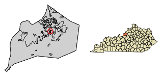
Bancroft is a home rule-class city in Jefferson County, Kentucky, United States. It was formally incorporated by the state assembly in 1970. The population was 494 at the 2010 census.

<span class="mw-page-title-main">Beechwood Village, Kentucky</span> City in Kentucky, United States

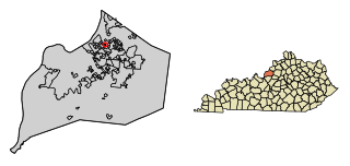
Beechwood Village is a home rule-class city in Jefferson County, Kentucky, United States. The city was formally incorporated by the state assembly in 1950. The population was 1,324 at the 2010 census, up from 1,173 at the 2000 census.

<span class="mw-page-title-main">Brownsboro Farm, Kentucky</span> City in Kentucky, United States

Brownsboro Farm is a home rule-class city in Jefferson County, Kentucky, United States. The population was 648 at the 2010 census.

<span class="mw-page-title-main">Brownsboro Village, Kentucky</span> City in Kentucky, United States

Brownsboro Village is a home rule-class city in Jefferson County, Kentucky, United States. The population was 319 at the 2010 census.

<span class="mw-page-title-main">Glenview Manor, Kentucky</span> City in Kentucky, United States

Glenview Manor is a home rule-class city in Jefferson County, Kentucky, United States. The population was 191 at the 2010 census.

<span class="mw-page-title-main">Hollow Creek, Kentucky</span> City in Kentucky, United States

Hollow Creek is a home rule-class city in Jefferson County, Kentucky, United States. The population was 783 at the 2010 census.

<span class="mw-page-title-main">Houston Acres, Kentucky</span> City in Kentucky, United States

Houston Acres is a home rule-class city in Jefferson County, Kentucky, United States. The population was 507 at the 2010 census.

<span class="mw-page-title-main">Meadowview Estates, Kentucky</span> City in Kentucky, United States

Meadowview Estates is a home rule-class city in Jefferson County, Kentucky, United States. The population was 178 at the 2020 census,.

<span class="mw-page-title-main">Norbourne Estates, Kentucky</span> City in Kentucky, United States

Norbourne Estates is a home rule-class city in Jefferson County, Kentucky, United States. The population was 441 at the 2010 census.

<span class="mw-page-title-main">Rolling Hills, Kentucky</span> City in Kentucky, United States

Rolling Hills is a home rule-class city in Jefferson County, Kentucky. The population was 959 at the time of the 2010 census.

<span class="mw-page-title-main">St. Regis Park, Kentucky</span> City in Kentucky, United States

St. Regis Park is a home rule-class city in Jefferson County, Kentucky, United States, and a part of the Louisville Metro government. The population was 1,454 as of the 2010 census.

<span class="mw-page-title-main">Thornhill, Kentucky</span> City in Kentucky, United States

Thornhill is a home rule-class city in Jefferson County, Kentucky, United States. The population was 178 at the 2010 census.

<span class="mw-page-title-main">West Buechel, Kentucky</span> City in Kentucky, United States

West Buechel is a home rule-class city in Jefferson County, Kentucky, United States. The population was 1,230 at the 2010 census, down from 1,301 at the 2000 census.

<span class="mw-page-title-main">Wildwood, Kentucky</span> City in Kentucky, United States

Wildwood is a home rule-class city in Jefferson County, Kentucky, United States. The population was 261 at the 2010 census.

<span class="mw-page-title-main">Windy Hills, Kentucky</span> City in Jefferson County, Kentucky, United States

Windy Hills is a home rule-class city, incorporated in 1952, in eastern Jefferson County, Kentucky, United States. The population was 2,385 at the 2010 census.

<span class="mw-page-title-main">Woodland Hills, Kentucky</span> City in Kentucky, United States

Woodland Hills is a home rule-class city in Jefferson County, Kentucky, United States. The population was 696 at the 2010 census.

<span class="mw-page-title-main">Otterville, Missouri</span> City in Missouri, United States

Otterville is a city in southwest Cooper County, Missouri, United States. The population was 454 at the 2010 census.

<span class="mw-page-title-main">New Haven, West Virginia</span> Town in West Virginia, United States

New Haven is a town in Mason County, West Virginia, United States, along the Ohio River. The population was 1,485 at the 2020 census. It is part of the Point Pleasant, WV–OH Micropolitan Statistical Area.

References

  1. "2020 U.S. Gazetteer Files". United States Census Bureau. Retrieved March 18, 2022.
  2. 1 2 "Geographic Identifiers: 2010 Census Summary File 1 (G001): Richlawn city, Kentucky". American Factfinder. U.S. Census Bureau. Archived from the original on February 13, 2020. Retrieved June 18, 2018.
  3. "US Gazetteer files: 2010, 2000, and 1990". United States Census Bureau. 2011-02-12. Retrieved 2011-04-23.
  4. "Census of Population and Housing". Census.gov. Retrieved June 4, 2015.
  5. "U.S. Census website". United States Census Bureau . Retrieved 2008-01-31.