
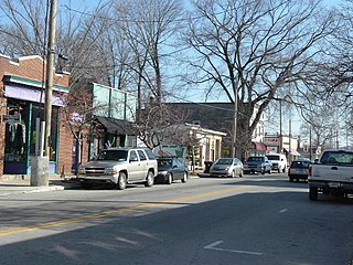
Shively is a home rule-class city in Jefferson County, Kentucky, United States, and a suburb of Louisville within the Louisville Metro government. As of the 2010 census, the city's population was 15,264, reflecting an increase of 107 (+0.7%) from 15,157 in 2000.

Portland is a neighborhood and former independent town northwest of downtown Louisville, Kentucky. It is situated along a bend of the Ohio River just below the Falls of the Ohio, where the river curves to the north and then to the south, thus placing Portland at the northern tip of urban Louisville. In its early days it was the largest of the six major settlements at the falls, the others being Shippingport and Louisville in Kentucky and New Albany, Clarksville, and Jeffersonville on the Indiana side. Its modern boundaries are the Ohio River along the northwest, north, and northeast, 10th Street at the far east, Market Street on the south, and the Shawnee Golf Course at the far west.

Russell is a neighborhood immediately west of downtown Louisville, Kentucky, USA. It was named for renowned African American educator and Bloomfield, Kentucky native Harvey Clarence Russell Sr. Its boundaries are West Market Street, 9th Street, West Broadway and I-264.
Chickasaw is a neighborhood in Louisville, Kentucky, USA. Its boundaries are West Broadway, 34th Street, Hale Avenue and Chickasaw Park.
Parkland is a neighborhood in Louisville, Kentucky, USA. Its boundaries are 34th Street on the west, West Broadway on the north, Woodland Avenue on the south, and 26th Street on the east.

The geology of the Ohio River, with but a single series of rapids halfway in its length from the confluence of the Monongahela and Allegheny rivers to its union with the Mississippi, made it inevitable that a town would grow on the site. Louisville, Kentucky was chartered in the late 18th century. From its early days on the frontier, it quickly grew to be a major trading and distribution center in the mid 19th century, important industrial city in the early 20th, declined in the mid 20th century, before revitalizing in the late 20th century as a culturally-focused mid-sized American city.

Butchertown is a neighborhood just east of downtown Louisville, Kentucky, USA, bounded by I-65, Main Street, I-71, Beargrass Creek and Mellwood Avenue.
Clifton is a neighborhood east of downtown Louisville, Kentucky USA. Clifton was named because of its hilly location on the Ohio River valley escarpment. Clifton is bounded by I-64, N Ewing Ave, Brownsboro Road, and Mellwood Ave.
Irish Hill is a neighborhood east of downtown Louisville, Kentucky USA. It is bounded by Baxter Avenue to the west, Lexington Road to the north, the middle fork of Beargrass Creek and I-64 to the east. Cave Hill Cemetery is located directly south of Irish Hill. It is in the inner Highlands area of Louisville.
Wilder Park is a neighborhood four miles south of downtown Louisville, Kentucky USA. The area was originally the site of Greenland race course, built in 1866, a sister track of Churchill Downs. Greenland track closed in 1888 and was subsequently used as a park.
Beechmont is a neighborhood in the south end of Louisville, Kentucky. Its modern boundaries are I-264 to the north, Taylor Boulevard to the west, Southern Parkway and Southland Boulevard to the south, and Third Street, Allmond and Louisville Avenues to the east.
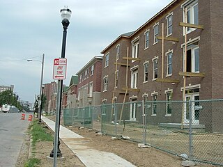
Park DuValle is a neighborhood southwest of downtown Louisville, Kentucky. Its boundaries are I-264 to the west, the Norfolk Southern Railway tracks to the north, Cypress Street to the east, and Bells Lane and Algonquin Parkway to the south. The neighborhood reflects the presence of several nearby parks, and DuValle Junior High School, named after Lucie DuValle, the first female principal of a high school in Louisville.
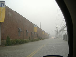
Phoenix Hill is a neighborhood of Louisville, Kentucky just east of Downtown. Its boundaries are Market Street to the North, Preston Street to the West, Broadway to the South, and Baxter Avenue to the East. The Phoenix Hill neighborhood, settled before 1850 by German immigrants, is now a rich tapestry of people and a diverse mix of business, industry and residences.
The Point was a thriving 19th century neighborhood in Louisville, Kentucky, east of Downtown Louisville and opposite Towhead Island along the Ohio River. It was also located north of the present day Butchertown area.
Fontaine Ferry Park was an amusement park in Louisville, Kentucky from 1905 to 1969. Located on 64 acres in western Louisville at the Ohio River, it offered over 50 rides and attractions, as well as a swimming pool, skating rink and theatre. The most popular attraction were its wooden roller coasters, of which 4 were built over the years.
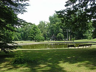
Shawnee Park is a municipal park in Louisville, Kentucky. It was designed by Frederick Law Olmsted, who designed 18 of the city's 123 public parks. Along with the rest of the city's Olmsted-designed park system, Shawnee Park was added to the National Register of Historic Places in 1982.
The Louisville riots of 1968 refers to riots in Louisville, Kentucky in May 1968. As in many other cities around the country, there were unrest and riots partially in response to the assassination of Martin Luther King Jr., on April 4. On May 27, a group of 400 people, mostly blacks, gathered at 28th and Greenwood Streets, in the Parkland neighborhood. The intersection, and Parkland in general, had recently become an important location for Louisville's black community, as the local NAACP branch had moved its office there.
The East Market District, colloquially referred to as NuLu, is an unofficial district of Louisville, Kentucky, situated along Market Street between downtown to the west and the Highlands neighborhoods to the east. A growing, hip district, the area comprises parts of two of Louisville's oldest neighborhoods, Butchertown and Phoenix Hill. The district is home to schools, churches, large and small businesses and some of the city's oldest homes and businesses. A destination since Louisville's founding, Market Street has played host to a variety of businesses throughout the city's history that have drawn Louisvillians for generations to its addresses.
On August 4, 2009, at 9:25 am EDT a major thunderstorm producing large hail and winds in excess of 60 mph (97 km/h) advanced at the leading edge of a cold front moving across the American Midwest, causing a flash flood that struck Louisville and portions of the surrounding Kentuckiana region. The National Weather Service estimated that between three to six inches of rain fell across the city in less than one hour, breaking all previous one-hour rainfall records in the area. Most of the downtown area was underwater, with the deluge reaching four feet (1.2 m) deep in places. The flood was the third major disaster to strike the region in less than one year.

The Cherokee Triangle is a historic neighborhood in Louisville, Kentucky, USA, known for its large homes displaying an eclectic mix of architectural styles. Its boundaries are Bardstown Road to the southwest, Cherokee Park and Eastern Parkway to the southeast, and Cave Hill Cemetery to the north, and is considered a part of a larger area of Louisville called The Highlands. It is named for nearby Cherokee Park, a 409 acres (1.7 km2) park designed by Frederick Law Olmsted, the designer of New York's Central Park.

