Ring of Brodgar

Last updated

Ring of Brodgar
Ring of Brodgar, Orkney.jpg
The ring with Loch of Harray beyond
Ring of Brodgar
Orkney Islands UK location map.svg
Archaeological site icon (red).svg
Shown within Orkney Islands
Location Mainland, Orkney, Scotland
Coordinates 59°00′05″N3°13′47″W / 59.0014818°N 3.2297227°W / 59.0014818; -3.2297227
Type Standing stones, henge
History
Periods Neolithic
Site notes
Ownership Historic Scotland [ needs update ]
Public accessYes
TypeCultural
Criteriai, ii, iii, iv
Designated1999 (23rd session)
Part of Heart of Neolithic Orkney
Reference no. 514
Region Western Europe
Identifiers
Historic Environment Scotland SM90042

The Ring of Brodgar (or Brogar, or Ring o' Brodgar) is a Neolithic henge and stone circle about 6 miles north-east of Stromness on Mainland, the largest island in Orkney, Scotland. It is part of the UNESCO World Heritage Site known as the Heart of Neolithic Orkney.

Contents

General information

Bren gun carriers of the 9th Battalion, Gordon Highlanders pass between the prehistoric standing stones 18 June 1941 Bren gun carriers of the 9th Battalion, Gordon Highlanders pass between the prehistoric standing stones of the Ring of Brodgar on Orkney, 18 June 1941. H10589.jpg
Bren gun carriers of the 9th Battalion, Gordon Highlanders pass between the prehistoric standing stones 18 June 1941

The Ring of Brodgar (or Brogar, or Ring o' Brodgar) is a Neolithic henge and stone circle in Mainland, Orkney, Scotland. It is the only major henge and stone circle in Britain which is an almost perfect circle. Most henges do not contain stone circles; Brodgar is a striking exception, ranking with Avebury and Stonehenge among the greatest of such sites. [1] The ring of stones stands on a small isthmus between the Lochs of Stenness and Harray. These are the northernmost examples of circle henges in Britain. [2] Unlike similar structures such as Avebury, there are no obvious stones inside the circle, [3] but since the interior of the circle has never been excavated by archaeologists, the possibility remains that wooden structures, for example, may have been present. The site has resisted attempts at scientific dating and the monument's age remains uncertain. It is generally thought to have been erected between 2500 BC and 2000 BC, and was, therefore, the last of the great Neolithic monuments built on the Ness. [4] A project called The Ring of Brodgar Excavation 2008 was undertaken in the summer of that year in an attempt to settle the age issue and help answer other questions about a site that remains relatively poorly understood. [5] The results of the excavation are still preliminary.

The stone circle is 104 metres (341 ft) in diameter, and the third largest in the British Isles. [4] The ring originally comprised up to 60 stones, of which only 27 remained standing at the end of the 20th century. The tallest stones stand at the south and west of the ring, including the "Comet Stone" to the south-east. [6] :42 The stones are set within a circular ditch up to 3 metres (9.8 ft) deep, 9 metres (30 ft) wide and 380 metres (1,250 ft) in circumference that was carved out of the solid sandstone bedrock by the ancient residents. [7] Technically, this ditch does not constitute a true henge as there is no sign of an encircling bank of earth and rock. Many archaeologists continue to refer to this structure as a henge; for example, Aubrey Burl classifies the ditch as a Class II henge; one that has two opposing entrances, in this case on the north-west and south-east. [8]

The ditch appears to have been created in sections, possibly by workforces from different parts of Orkney. The stones may have been a later addition, maybe erected over a long period of time. [6] :42

Examination of the immediate environs reveals a concentration of ancient sites, making a significant ritual landscape. Within 2 square miles (5.2 km2) there are the two circle-henges, four chambered tombs, groups of standing stones, single stones, barrows, cairns, and mounds. [9] The immediate area has also yielded a number of flint arrowheads and broken stone mace-heads that seem to date from the Bronze Age. [10] Although its exact purpose is not known, the proximity of the Standing Stones of Stenness and its Maeshowe tomb make the Ring of Brodgar a site of major importance. The site is a scheduled monument and has been recognized as part of the "Heart of Neolithic Orkney" World Heritage Site in 1999.

RingofBrodgar.jpg
The Ring of Brodgar

World Heritage status

The Heart of Neolithic Orkney was inscribed as a World Heritage site in December 1999. In addition to the Ring of Brodgar, the site includes Maeshowe, Skara Brae, the Standing Stones of Stenness and other nearby sites. It is managed by Historic Environment Scotland, whose 'Statement of Significance' for the site begins:

The monuments at the heart of Neolithic Orkney and Skara Brae proclaim the triumphs of the human spirit in early ages and isolated places. They were approximately contemporary with the mastabas of the archaic period of Egypt (first and second dynasties), the brick temples of Sumeria, and the first cities of the Harappa culture in India, and a century or two earlier than the Golden Age of China. Unusually fine for their early date, and with a remarkably rich survival of evidence, these sites stand as a visible symbol of the achievements of early peoples away from the traditional centres of civilisation...The Ring of Brodgar is the finest known truly circular late Neolithic or early Bronze Age stone ring and a later expression of the spirit which gave rise to Maeshowe, Stenness and Skara Brae [11]

The first formal survey of the Ring of Brodgar and surrounding antiquities was performed in 1849 by Royal Navy Captain F.W.L. Thomas of HM cutter Woodlark. [12] Captain Thomas was in the area drawing up Admiralty Charts in 1848–49, and he and his crew performed archaeological surveys as well resulting in the publication in 1852 of The Celtic Antiquities of Orkney. [13]

Excavations of Neolithic ruins

Neolithic settlement at Brodgar, (August 2014) Neolithic settlement at Brodgar (geograph 4125928).jpg
Neolithic settlement at Brodgar, (August 2014)

Ongoing excavations by Orkney College at the nearby Ness of Brodgar site located roughly midway between the Ring and the Stones of Stenness have uncovered several buildings, both ritual and domestic. Geophysics suggest there are likely to be more in the vicinity. Pottery, bones, stone tools and a polished stone mace head have also been discovered. Perhaps the most important find is the remains of a large stone wall which may have been 100 metres (330 ft) long and up to 6 metres (20 ft) wide. It appears to traverse the entire peninsula the site is on and may have been a symbolic barrier between the ritual landscape of the Ring and the mundane world around it. [14]

Nordic rites

1823 woodcut, the Ring of Brodgar & surroundings Brodgar woodcut.jpg
1823 woodcut, the Ring of Brodgar & surroundings

Invaders from Scandinavia reached Orkney by the 9th century, bringing a complex theology that they imposed on the preexisting Orcadian monuments; at least according to local legend. For example, the Ring of Brodgar and the Standing Stones of Stenness were allegedly known as the Temple of the Sun and Moon respectively. [15] Young people supposedly made their vows and prayed to Wōden at these "temples" and at the so-called "Odin Stone" that lay between the stone circles until it was destroyed by a farmer in 1814. [15] Others view these fanciful names with skepticism; Sigurd Towrie suggests that "they were simply erroneous terms applied by the antiquarians of the 18th or 19th centuries – romantic additions, in the same vein as the infamous "Druid's Circle" and "Sacrificial Altar"." [16] At the very least, several of the stones at Brodgar contain runic carvings that were left by Nordic peoples. [17] These include the name "Bjorn" and a small cross as well as an anvil. [6] :42

Ring of Brodgar, Orkney Standing Stones 02.tif
Ring of Brodgar, Orkney Standing Stones 02

"Megalithic Yard" and Neolithic astronomers at Brodgar

The Ring of Brodgar Ring of Brodgar in summer 2012 (3).JPG
The Ring of Brodgar
The Ring of Brodgar seen from above Ring of Brodgar, 2007, aerial - geograph.org.uk - 3148599.jpg
The Ring of Brodgar seen from above

Burl [18] notes that the diameter of the bank at Brodgar is almost exactly the same as the inner banks of the Avebury monument in England and the Newgrange ring in Ireland: 125 "megalithic yards" (MY), at 0.8297 metres (2.722 ft) per MY. This is a controversial unit originally proposed by Alexander Thom. [19] Thom's thesis, based on a statistical analysis of Neolithic monuments in the United Kingdom, is that the builders of these sites employed a common unit of measurement, although it has not been demonstrated how this information could have been shared:. [20]

Heggie casts doubt on this as well, stating that his careful analysis uncovered "little evidence for a highly accurate unit" and "little justification for the claim that a highly accurate unit was in use". [21] Thom and his father made other controversial contentions, for example, that Brodgar and the burial mounds that surround it were designed specifically as backsights for astronomical observations of the Moon. [22] Graham Ritchie points out that the burial mounds have not been reliably dated, and he casts doubt on the astronomical prowess of the builders. [23]

Euan MacKie suggested that the nearby village of Skara Brae might be the home of a privileged theocratic class of wise men who engaged in astronomical and magical ceremonies at sites like Brodgar and Stenness. [24] Graham and Anna Ritchie cast doubt on this interpretation noting that there is no archaeological evidence for the claim, [25] although a Neolithic "low road" connects Skara Brae with the chambered tomb of Maeshowe, passing near Brodgar and Stenness. [26] Low roads connect Neolithic ceremonial sites throughout Britain.

Cultural impact

The Ring of Brodgar features in Kathleen Fidler's 1968 novel The Boy with the Bronze Axe; here, it is depicted in a midsummer ceremony in which a lamb is sacrificed. In Fidler's story, women are forbidden from entering the Ring, which is a male-only space. [27]

In Troika Games 2001 title Arcanum: Of Steamworks and Magick Obscura , the Ring of Brodgar appears in the town of Roseborough and is pivotal to the plot.

See also

Notes

  1. Ritchie 1985, p. 119
  2. Hawkes 1986, p. 261
  3. Hadingham, 1975, pp.55–56
  4. 1 2 "The Ring of Brodgar, Stenness, Orkney". www.orkneyjar.com. Retrieved 2 April 2018.
  5. "Orkneyjar Archeology News - The Ring of Brodgar Excavation 2008". www.orkneyjar.com.
  6. 1 2 3 Wickham-Jones, Caroline (2012). Monuments of Orkney. Historic Scotland. ISBN   978-1-84917-073-4.
  7. Hawkes 1986, p. 262
  8. Burl 1976, p. 101
  9. Laing 1974, p. 84
  10. Childe 1952, p. 35
  11. "The Heart of Neolithic Orkney". Historic Scotland. Retrieved on 5 September 2007
  12. Hedges 1984, p. 22
  13. Thomas, F. W. L. (1852) "Account of some of the Celtic antiquities of Orkney, including the Stones of Stenness, Tumuli, Picts-houses, etc. with plans" Archived 2009-06-24 at the Wayback Machine Archaeologia 34. pp. 88–136. Retrieved 31 August 2008.
  14. Ross, John (14 August 2007) "Experts uncover Orkney's new Skara Brae and the great wall that separated living from dead". Edinburgh. The Scotsman.
  15. 1 2 Hedges 1984, p. 13
  16. Sigurd Towrie. "The Temples of the Sun and Moon: True tradition or romantic addition?". Orkneyjar. Archived from the original on 20 January 2017. Retrieved 23 May 2018.
  17. Laing 1974, p. 233
  18. Burl 1976, p. 99
  19. Thom 1955
  20. Burl 1976, p. 71
  21. Heggie 1981 p. 58
  22. Thom & Thom 1973
  23. Ritchie 1985, p. 127
  24. MacKie 1977
  25. Ritchie 1981, pp. 51–52
  26. Castleden 1987, p. 117
  27. Bramwell 2009, p. 184.

Related Research Articles

<span class="mw-page-title-main">Chambered cairn</span> Burial monument (Usually Neolithic)

A chambered cairn is a burial monument, usually constructed during the Neolithic, consisting of a sizeable chamber around and over which a cairn of stones was constructed. Some chambered cairns are also passage-graves. They are found throughout Britain and Ireland, with the largest number in Scotland.

<span class="mw-page-title-main">Maeshowe</span> Neolithic chambered cairn and passage grave situated on Mainland Orkney, Scotland

Maeshowe is a Neolithic chambered cairn and passage grave situated on Mainland Orkney, Scotland. It was probably built around 2800 BC. In the archaeology of Scotland, it gives its name to the Maeshowe type of chambered cairn, which is limited to Orkney.

<span class="mw-page-title-main">Skara Brae</span> Neolithic archaeological site in Scotland

Skara Brae is a stone-built Neolithic settlement, located on the Bay of Skaill on the west coast of Mainland, the largest island in the Orkney archipelago of Scotland. It consisted of ten clustered houses, made of flagstones, in earthen dams that provided support for the walls; the houses included stone hearths, beds, and cupboards. A primitive sewer system, with "toilets" and drains in each house, included water used to flush waste into a drain and out to the ocean.

<span class="mw-page-title-main">Henge</span> Type of Neolithic earthwork

A henge loosely describes one of three related types of Neolithic earthwork. The essential characteristic of all three is that they feature a ring-shaped bank and ditch, with the ditch inside the bank. Because the internal ditches would have served defensive purposes poorly, henges are not considered to have been defensive constructions. The three henge types are as follows, with the figure in brackets being the approximate diameter of the central flat area:

  1. Henge. The word henge refers to a particular type of earthwork of the Neolithic period, typically consisting of a roughly circular or oval-shaped bank with an internal ditch surrounding a central flat area of more than 20 m (66 ft) in diameter. There is typically little if any evidence of occupation in a henge, although they may contain ritual structures such as stone circles, timber circles and coves. Henge monument is sometimes used as a synonym for henge. Henges sometimes, but by no means always, featured stone or timber circles, and circle henge is sometimes used to describe these structures. The three largest stone circles in Britain are each within a henge. Examples of henges without significant internal monuments are the three henges of Thornborough Henges. Although having given its name to the word henge, Stonehenge is atypical in that the ditch is outside the main earthwork bank.
  2. Hengiform monument. Like an ordinary henge, except the central flat area is between 5 and 20 m (16–66 ft) in diameter, they comprise a modest earthwork with a fairly wide outer bank. The terms mini-henge or Dorchester henge are sometimes used as synonyms for hengiform monument. An example is the Neolithic site at Wormy Hillock Henge.
  3. Henge enclosure. A Neolithic ring earthwork with the ditch inside the bank, with the central flat area having abundant evidence of occupation and usually being more than 300 m (980 ft) in diameter. Some true henges are as large as this, but lack evidence of domestic occupation. Super-henge or superhenge is sometimes used as a synonym for a henge enclosure. However, sometimes the term is used to indicate size alone rather than use, e.g. "Marden henge ... is the least understood of the four British 'superhenges' ".
<span class="mw-page-title-main">Avebury</span> Neolithic henge monument in Wiltshire, England

Avebury is a Neolithic henge monument containing three stone circles, around the village of Avebury in Wiltshire, in south-west England. One of the best-known prehistoric sites in Britain, it contains the largest megalithic stone circle in the world. It is both a tourist attraction and a place of religious importance to contemporary pagans.

<span class="mw-page-title-main">Unstan ware</span> Type of pottery

Unstan ware is the name used by archaeologists for a type of finely made and decorated Neolithic pottery from the 4th and 3rd millennia BC. Typical are elegant and distinctive shallow bowls with a band of grooved patterning below the rim, a type of decoration which was created using a technique known as "stab-and-drag". A second version consists of undecorated, round-bottomed bowls. Some of the bowls had bits of volcanic rock included in the clay to make them stronger. Bone tools were used to burnish the surfaces to make them shiny and impermeable.

<span class="mw-page-title-main">Stones of Stenness</span> Henge in Orkney Islands, Scotland, UK

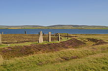
The Standing Stones of Stenness is a Neolithic monument five miles northeast of Stromness on the mainland of Orkney, Scotland. This may be the oldest henge site in the British Isles. Various traditions associated with the stones survived into the modern era and they form part of the Heart of Neolithic Orkney World Heritage Site. They are looked after by Historic Environment Scotland as a scheduled monument.

<span class="mw-page-title-main">Barnhouse Settlement</span>

The Neolithic Barnhouse Settlement is sited by the shore of Loch of Harray, Orkney Mainland, Scotland, not far from the Standing Stones of Stenness, about 5 miles north-east of Stromness.

<span class="mw-page-title-main">Dwarfie Stane</span> Carved Megalithic chambered tomb in Scotland

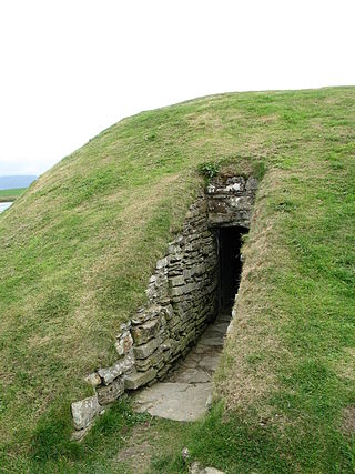
The Dwarfie Stane is a megalithic chambered tomb carved out of a titanic block of Devonian Old Red Sandstone located in a steep-sided glaciated valley between the settlements of Quoys and Rackwick on Hoy, an island in Orkney, Scotland. The stone is a glacial erratic located in desolate peatland. The site is managed by Historic Environment Scotland.

<span class="mw-page-title-main">Heart of Neolithic Orkney</span> UNESCO World Heritage Site in Orkney, Scotland

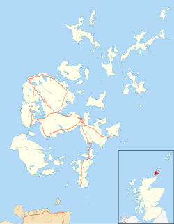
Heart of Neolithic Orkney is a group of Neolithic monuments on the Mainland of the Orkney Islands, Scotland. The name was adopted by UNESCO when it proclaimed these sites as a World Heritage Site in December 1999.

<span class="mw-page-title-main">Loch of Stenness</span> Brackish loch in Orkney, Scotland

The Loch of Stenness is a large brackish loch on Mainland, Orkney, Scotland and is named for the parish of Stenness. It is 2 miles northeast of the town of Stromness, lies immediately to the south of the Loch of Harray and is close to the World Heritage neolithic sites of the Stones of Stenness and Ring of Brodgar. In Old Norse its name was Steinnesvatn.

<span class="mw-page-title-main">Prehistoric Orkney</span> Overview of the prehistoric period on the Orkney Islands, Scotland

Prehistoric Orkney refers only to the prehistory of the Orkney archipelago of Scotland that begins with human occupation. Although some records referring to Orkney survive that were written during the Roman invasions of Scotland, “prehistory” in northern Scotland is defined as lasting until the start of Scotland's Early Historic Period.

<span class="mw-page-title-main">Unstan Chambered Cairn</span> Neolithic chambered cairn

Unstan is a Neolithic chambered cairn located about 2 mi (3 km) north-east of Stromness on Mainland, Orkney, Scotland. The tomb was built on a promontory that extends into the Loch of Stenness near the settlement of Howe. Unstan is notable as an atypical hybrid of the two main types of chambered cairn found in Orkney, and as the location of the first discovery of a type of pottery that now bears the name of the tomb. The site is in the care of Historic Environment Scotland as a scheduled monument.

<span class="mw-page-title-main">Ness of Brodgar</span> British archaeological site

The Ness of Brodgar is an archaeological site covering 2.5 hectares between the Ring of Brodgar and the Stones of Stenness in the Heart of Neolithic Orkney World Heritage Site on the main Island of Orkney, Scotland. Excavations at the site began in 2003. The site has provided evidence of decorated stone slabs, a stone wall 6 metres (20 ft) thick with foundations, and a large building described as a Neolithic temple. The earliest structures were built between 3,300 and 3,200 BC, and the site had been closed down and partly dismantled by 2,200 BC. It was the main subject of a 2016 BBC Scotland documentary, Britain’s Ancient Capital: Secrets of Orkney, presented by Neil Oliver, Chris Packham, Shini Somara, Andy Torbet, and Doug Allan. For preservation, the site is closed during the winter months and covered in polyethylene plastic and tyres to protect it from the environment.

<span class="mw-page-title-main">Stone circles in the British Isles and Brittany</span> Megalithic tradition of monuments

The stone circles in the British Isles and Brittany are a megalithic tradition of monuments consisting of standing stones arranged in rings. These were constructed from 3300 to 900 BCE in Britain, Ireland and Brittany. It has been estimated that around 4,000 of these monuments were originally constructed in this part of north-western Europe during this period. Around 1,300 of them are recorded, the others having been destroyed.

<i>Rites of the Gods</i> Book by Aubrey Burl

Rites of the Gods is an archaeological study of religious belief and ritual practices across prehistoric Britain from the Old Stone Age through to the Iron Age. Written by the prominent English archaeologist and megalithic specialist Aubrey Burl, it was first published in 1981 by J.M. Dent & Sons Ltd.

<span class="mw-page-title-main">Hoy and West Mainland National Scenic Area</span>

Hoy and West Mainland is a national scenic area (NSA) covering parts of the islands of Hoy and Mainland in the Orkney Islands of Scotland, as well as parts of the surrounding sea. It is one of 40 such areas in Scotland, which are defined so as to identify areas of exceptional scenery and to ensure its protection by restricting certain forms of development. The Hoy and West Mainland NSA covers 24,407 ha in total, consisting of 16,479 ha of land with a further 7928 ha being marine.

Tisbury Stone Circle and Henge was a stone circle and henge in Tisbury, Wiltshire. Archaeologists believe that it was likely erected during the Bronze Age.

References