A rocca (literally: "rock") is a type of Italian fortified stronghold, or fortress, typically located on a hilltop, beneath or on which the inhabitants of a historically clustered village or town might take refuge at times of trouble. Generally under its owners' patronage, the settlement might hope to find prosperity in better times. A rocca might in reality be no grander than a fortified farmhouse. A more extensive rocca would be referred to as a castello.
The rocca in Roman times would more likely be a site of a venerable cult than a dwelling, like the high place of Athens, its Acropolis. Though the earliest documentation is not earlier than the eleventh century, it was during the Lombard times that farming communities, which had presented a Roman pattern of loosely distributed farmsteads or self-sufficient Roman villa, moved from their traditional places on the fringes of the best arable lands in river valleys, where they were dangerously vulnerable from the Roman roads, to defensive positions, such as had once been occupied by Etruscan settlements, before the settled conditions of the Pax Romana. Historian J.B. Ward-Perkins made the following observation regarding the rocca at the town of Falerii.[1]
At Falerii ... the inhabitants simply transferred their town back from its Roman site on the open plateau to the old cliff-top site of Falerii Veteres, to which they gave the significant name of Civita Castellana, or "the Fortress Town"; just as in antiquity, security was once again the basic consideration.
Similarly, in Greek-speaking Campania, the inhabitants of Paestum finally abandoned their town after raids by Saracens and moved a few miles to the top of a cliff, calling the new settlement Agropoli (i.e., "acropolis"). Where such fortress villages were sited at the end of a ridge, protected on three sides by steep, cliff-like escarpments, the rocca was often sited to control the narrow access along the crest of the spur.
Locally the term la rocca simply designates the local fortified high place.
Examples
Specific examples show the range of structures that may be called a rocca:
Rocca Sanvitale, began in the 13th century, mostly completed by the 15th century, is a remarkable fortress house in the town of Fontanellato, near Parma.
Rocca Flea is a fortified palazzo in Gualdo Tadino, Umbria.
In Valletta, Malta, Casa Rocca Piccola is one of the last remaining unconverted palazzi, that is still lived in today by a noble family.
In Sardinia, the Rocca Doria, a stronghold of the Doria of Genoa, gives its name to the commune Monteleone Rocca Doria.
From the earliest stage, when church and rocca were the only stone structures[2] "the distinction between 'castles' and 'villages' is already one of degree rather than kind." (Ward-Perkins 1962:401) Their protective rocca has extended its name to many other small communities:
Rocca di Papa in the region called Castelli Romani in the hills surrounding Lazio has given its name to its comune. Twelfth-century documents name the Castrum Rocce de Papa ("Rock Castle of the Pope"), because here lived Pope Eugene III.
↑ J.B. Ward-Perkins, "Etruscan Towns, Roman Roads and Medieval Villages: The Historical Geography of Southern Etruria" The Geographical Journal128.4 (December 1962:389-404) pp 399ff. Ward-Perkins notes the establishment of a villa of Roman pattern as late as ca 780, Pope Hadrian I's recently rediscovered Domusculta Capracorum near Veii, which Ward-Perkins does not take as exceptional but as evidence "that the system of land tenure operating in the territory of Veii at the end of the eighth century was still one of villas and large, open estates on the late Roman model" (Ward-Perkins 1962:402); villages were carved out of the former estate in the tenth century.
↑ Ward-Perkins 1962:401 points out that the familiar "medieval" character of surviving villages, with their cobbled streets and stone houses washed with colorful intonaco, upon examination are invariably structures built in the sixteenth century and later.
Veii was an important ancient Etruscan city situated on the southern limits of Etruria and only 16 km (9.9 mi) north-northwest of Rome, Italy. It now lies in Isola Farnese, in the comune of Rome. Many other sites associated with and in the city-state of Veii are in Formello, immediately to the north. Formello is named after the drainage channels that were first created by the Veians.
Falerii was a city in southern Etruria, 50 km northeast of Rome, 34 km from Veii, 16 km form Rome) and about 1.5 km west of the ancient Via Flaminia. It was the main city of the Faliscans, a people whose language was a Latin dialect and was part of the Latino-Faliscan language group. The Ager Faliscus, which included the towns of Capena, Nepet (Nepi) and Sutrium (Sutri), was close to the Monti Cimini.
Santo Stefano can refer to:
The Province of L'Aquila is the largest, most mountainous and least densely populated province of the Abruzzo region of Southern Italy. It comprises about half the landmass of Abruzzo and occupies the western part of the region. It has borders with the provinces of Teramo to the north, Pescara and Chieti to the east, Isernia to the south and Frosinone, Rome and Rieti to the west. Its capital is the city of L'Aquila.
Formello is a town and comune in the Metropolitan City of Rome. It is located southwest of the Monti Sabatini, within the Regional Park of Veii. The communal territory is mostly composed by tuff, and is intensively cultivated.
Urbisaglia is a comune in the province of Macerata, Marche, Italy. Its name comes from the ancient Roman town Urbs Salvia.
Poggio is an Italian word meaning "knoll". It may refer to:
Meldola is a town and comune near Forlì, in Emilia-Romagna, Italy.
Bassano Romano is a town and comune in the province of Viterbo, in northern Lazio (Italy). With its origins about 1000 as the agricultural hamlet of Bassano di Sutri the village's future was founded in 1160 by the wealthy landowner Enotrio Serco, who initiated the construction at the top of the slope of a fortified residence that over the centuries became a princely dwelling, frescoed by famous artists. In 1482 Pope Sixtus IV assigned the Foedus Bassani to the Anguillara, Roman patricians . The growth of the comune redoubled after 1565, when the signory was reassigned by Pope Clement VIII to the Giustiniani, merchants of Genoese origin settled at Rome. In 1605 the signory was raised to a marquessate: a hunting lodge called "La Rocca", granaries, a stone bridge and the church dedicated to San Vincenzo were all constructed. During the Giustiniani residence, artists were commissioned to carry out frescoes: Francesco Albani, Domenico Zampieri "Domenichino" and Antonio Tempesta are all represented. In 1644, a bulla of Pope Innocent X made the marchese of Bassano a prince, and the flock of papal and noble visitors included James Stuart, pretender to the thrones of England and Scotland. In 1735, under Giustiniani patronage the maiolica manufactory of Bartolomeo Terchi was transferred here from Siena.
Acciano is a comune in the Province of L'Aquila in the Abruzzo region of Italy. The small, medieval village is in the Subequana valley and is a part of the Sirentina Mountain Community.
Calascio is a comune and village in the province of L'Aquila, in the Abruzzo region of central Italy. It is located in the Gran Sasso e Monti della Laga National Park.
Oricola is a comune and town in the province of L'Aquila, Abruzzo, central Italy, located near the regional boundary with Latium. It is commanded by a mid-15th century rocca (fortress) and, in its communal territory, is home to the remains of several ancient Italic settlements. The church of Santa Restituta contains a 13th-century fresco.
Ortona dei Marsi is a comune and town in the province of L'Aquila in the Abruzzo region of central Italy. It is included in traditional area of Marsica. The commune is part of the National Park of Abruzzo, Lazio and Molise. Ortona dei Marsi is situated on 1000 meters above sea level and the mountains that surround the valley reach up to 1,800 meters.
Rocca di Botte is a comune and town of 860 people in the province of L'Aquila, Abruzzo, central Italy.
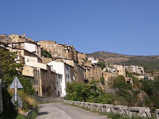
Roccacasale is a comune in the Province of L'Aquila in the Abruzzo region of Italy. Built on the slopes of the Monte della Rocca in the central Apennines, the village overlooks the Peligna Valley and the town of Sulmona.
Tornimparte is a comune and town in the province of L'Aquila in the Abruzzo region of central-southern Italy.
Campagnano di Roma is a comune (municipality) in the Metropolitan City of Rome in the Italian region Latium, located about 30 kilometres northwest of Rome. It was first mentioned in 1076, having been carved out of the great estate assembled on the Roman pattern by Pope Adrian I, ca. 780, his Domusculta Capracorum. In medieval times, Campagnano di Roma was on the via Francigena. Here, Sigeric, Archbishop of Canterbury, sojourned on his return journey from Rome about 990.
Mazzano Romano is a comune (municipality) in the Metropolitan City of Rome in the Italian region Latium, located about 35 kilometres (22 mi) north of Rome.
Mignano Monte Lungo is a comune (municipality) in the Province of Caserta in the Italian region Campania, located about 70 kilometres (43 mi) northwest of Naples and about 45 kilometres (28 mi) northwest of Caserta.
The Rocca di Urbisaglia is a 16th-century military fortification, including ruins of medieval fortifications and Roman walls. Its imposing position, dominating the urban area and the Fiastra Valley below, suggests that the Arx or the Capitol of the Roman town Urbs Salvia was once located here.
This page is based on this Wikipedia article Text is available under the CC BY-SA 4.0 license; additional terms may apply. Images, videos and audio are available under their respective licenses.