Russell, Iowa

Last updated

Russell, Iowa
Lucas County Iowa Incorporated and Unincorporated areas Russell Highlighted.svg
Location of Russell, Iowa
Coordinates: 40°58′49″N93°12′02″W / 40.98028°N 93.20056°W / 40.98028; -93.20056
Country United States
State Iowa
County Lucas
Incorporated April 25, 1887 [1]
Area
[2]
  Total1.02 sq mi (2.66 km2)
  Land1.02 sq mi (2.66 km2)
  Water0.00 sq mi (0.00 km2)
Elevation
[3]
1,024 ft (312 m)
Population
 (2020)
  Total472
  Density460.49/sq mi (177.75/km2)
Time zone UTC-6 (Central (CST))
  Summer (DST) UTC-5 (CDT)
ZIP code
50238
Area code 641
FIPS code 19-69285
GNIS feature ID2396456 [3]

Russell is a city in Lucas County, Iowa, United States. The population was 472 in the 2020 census, a decline from the 559 population in 2000. [4]

Contents

History

Russell was incorporated as a city on April 25, 1887. [1]

The town was originally settled by German and Irish settlers in the 1850s. By the early 1860s the town of Russell had been made into a farming community and provided a source of food for surrounding communities. After being incorporated, a railway and railroad grain-tower were constructed along the town's edge allowing excess produce to be travelled elsewhere on the frontier.

In 1935, the town suffered a fire on the town square that burned down the eastern side and killed 3 people.

Geography

According to the United States Census Bureau, the city has a total area of 1.04 square miles (2.69 km2), all land. [5]

Demographics

Historical population
CensusPop.Note
1870 175
1880 34597.1%
1890 44328.4%
1900 63643.6%
1910 612−3.8%
1920 6333.4%
1930 571−9.8%
1940 64212.4%
1950 566−11.8%
1960 5771.9%
1970 5912.4%
1980 5930.3%
1990 531−10.5%
2000 5595.3%
2010 554−0.9%
2020 472−14.8%
U.S. Decennial Census [6] [4]

2010 census

As of the census [7] of 2010, there were 554 people, 212 households, and 146 families residing in the city. The population density was 532.7 inhabitants per square mile (205.7/km2). There were 250 housing units at an average density of 240.4 per square mile (92.8/km2). The racial makeup of the city was 96.9% White, 0.4% African American, 2.2% Native American, and 0.5% from other races. Hispanic or Latino of any race were 2.0% of the population.

There were 212 households, of which 34.9% had children under the age of 18 living with them, 53.3% were married couples living together, 11.3% had a female householder with no husband present, 4.2% had a male householder with no wife present, and 31.1% were non-families. 27.4% of all households were made up of individuals, and 17.4% had someone living alone who was 65 years of age or older. The average household size was 2.61 and the average family size was 3.10.

The median age in the city was 39.4 years. 29.6% of residents were under the age of 18; 6.4% were between the ages of 18 and 24; 22.7% were from 25 to 44; 23.7% were from 45 to 64; and 17.7% were 65 years of age or older. The gender makeup of the city was 49.8% male and 50.2% female.

2000 census

As of the census [8] of 2000, there were 559 people, 239 households, and 144 families residing in the city. The population density was 539.7 inhabitants per square mile (208.4/km2). There were 265 housing units at an average density of 255.8 per square mile (98.8/km2). The racial makeup of the city was 98.57% White, 0.18% Native American, 0.36% Asian, and 0.89% from two or more races. Hispanic or Latino of any race were 0.36% of the population.

There were 239 households, out of which 29.3% had children under the age of 18 living with them, 50.2% were married couples living together, 6.7% had a female householder with no husband present, and 39.7% were non-families. 33.1% of all households were made up of individuals, and 19.7% had someone living alone who was 65 years of age or older. The average household size was 2.34 and the average family size was 2.97.

In the city, the population was spread out, with 27.0% under the age of 18, 6.8% from 18 to 24, 24.0% from 25 to 44, 19.3% from 45 to 64, and 22.9% who were 65 years of age or older. The median age was 40 years. For every 100 females, there were 89.5 males. For every 100 females age 18 and over, there were 92.5 males.

The median income for a household in the city was $28,125, and the median income for a family was $29,688. Males had a median income of $26,094 versus $16,406 for females. The per capita income for the city was $13,093. About 16.5% of families and 23.6% of the population were below the poverty line, including 42.6% of those under age 18 and 9.0% of those age 65 or over.

Schools

The city is within the Chariton Community School District, [9] which operates Chariton High School.

The Russell Community School District at one time maintained its own K-12 school, with a five-member board of education overseeing operation of the district. Athletic teams were known as the Trojans.

The Russell School District was forced to close in 2008, making it the second time this happened in the state of Iowa; the other was Hedrick in 1990. The Iowa Board of Education cited the district's financial problems, which left Russell school officials unable to provide students with a first-rate education. [10]

Notable people


Related Research Articles

<span class="mw-page-title-main">Lucas County, Iowa</span> County in Iowa, United States

Lucas County is a county located in the U.S. state of Iowa. As of the 2020 census, the population was 8,634. The county seat is Chariton. The county was formed in 1846 and was named for Robert Lucas, a Governor of the Territory.

<span class="mw-page-title-main">Rathbun, Iowa</span> City in Iowa, USA

Rathbun is a city in Appanoose County, Iowa, United States. The population was 43 at the time of the 2020 census.

<span class="mw-page-title-main">Willey, Iowa</span> City in Iowa, United States

Willey is a city in Carroll County, Iowa, United States. The population was 73 at the time of the 2020 census.

<span class="mw-page-title-main">Woodbine, Iowa</span> City in Iowa, United States

Woodbine is a city in Harrison County, Iowa, United States, along the Boyer River. The population was 1,625 at the time of the 2020 census.

<span class="mw-page-title-main">Hayesville, Iowa</span> City in Iowa, United States

Hayesville is a city in Keokuk County, Iowa, United States. The population was 41 at the time of the 2020 census.

<span class="mw-page-title-main">Chariton, Iowa</span> City in Iowa, USA

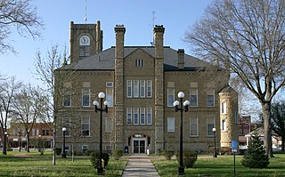
Chariton is a city in, and the county seat of, Lucas County, Iowa, United States. The population was 4,193 at the 2020 census. Lucas is the primary distribution center for and the former corporate headquarters of the Hy-Vee supermarket chain.

<span class="mw-page-title-main">Lucas, Iowa</span> City in Iowa, USA

Lucas is a city in Lucas County, Iowa, United States. The population was 172 at the time of the 2020 census.

<span class="mw-page-title-main">Williamson, Iowa</span> City in Iowa, United States

Williamson is a city in Lucas County, Iowa, United States. The population was 120 at the time of the 2020 census.

<span class="mw-page-title-main">Emerson, Iowa</span> City in Iowa, United States

Emerson is a city in Mills County, Iowa, United States. The population was 403 at the time of the 2020 census.

<span class="mw-page-title-main">Braddyville, Iowa</span> City in Iowa, United States

Braddyville is a city in Page County, Iowa, United States. The population was 147 at the 2020 census.

<span class="mw-page-title-main">Carson, Iowa</span> City in Iowa, United States

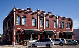
Carson is a city in Pottawattamie County, Iowa, United States. The population was 766 at the 2020 census. Carson has a number of interesting and historic places.

<span class="mw-page-title-main">Macedonia, Iowa</span> City in Iowa, United States

Macedonia is a city in Pottawattamie County, Iowa, United States. The population was 267 at the time of the 2020 census.

<span class="mw-page-title-main">McClelland, Iowa</span> City in Iowa, United States

McClelland is a city in Pottawattamie County, Iowa, United States. The city was founded in 1903 after the Great Western Railroad was extended to include Council Bluffs, Iowa The population was 146 at the time of the 2020 census.

<span class="mw-page-title-main">Neola, Iowa</span> City in Iowa, United States

Neola is a city in Pottawattamie County, Iowa, United States. The population was 918 at the time of the 2020 census.

<span class="mw-page-title-main">Dixon, Iowa</span> City in Iowa, United States

Dixon is a city in Scott County, Iowa, United States. The population was 202 at the time of the 2020 census.

<span class="mw-page-title-main">Mendon, Missouri</span> City in Missouri, United States

Mendon is a city in western Chariton County, Missouri, United States. The population was 163 at the 2020 census.

<span class="mw-page-title-main">Triplett, Missouri</span> City in Missouri, United States

Triplett is a city in Chariton County, Missouri, United States. The population was 33 at the 2020 census.

<span class="mw-page-title-main">North English, Iowa</span> City in Iowa, United States

North English is a city located mainly in Iowa county with a small portion in Keokuk county in the U.S. state of Iowa. The population was 1,065 at the time of the 2020 census. It is named for the English River.

<span class="mw-page-title-main">Bevington, Iowa</span> City in Iowa, United States

Bevington is a city in Madison and Warren Counties in the U.S. state of Iowa. The population was 57 at the 2020 census. It is part of the Des Moines–West Des Moines Metropolitan Statistical Area.

<span class="mw-page-title-main">Barnes City, Iowa</span> City in Iowa, United States

Barnes City is a city in Mahaska and Poweshiek counties in the U.S. state of Iowa. The population was 156 at the 2020 census.

References

  1. 1 2 "LIST OF INCORPORATED CITIES" (PDF). Iowa Secretary of State - Matt Schultz. Retrieved August 7, 2011.
  2. "2020 U.S. Gazetteer Files". United States Census Bureau. Retrieved March 16, 2022.
  3. 1 2 U.S. Geological Survey Geographic Names Information System: Russell, Iowa
  4. 1 2 "2020 Census State Redistricting Data". census.gov. United states Census Bureau. Retrieved August 12, 2021.
  5. "US Gazetteer files 2010". United States Census Bureau. Archived from the original on January 25, 2012. Retrieved May 11, 2012.
  6. "Census of Population and Housing". Census.gov. Retrieved June 4, 2015.
  7. "U.S. Census website". United States Census Bureau . Retrieved May 11, 2012.
  8. "U.S. Census website". United States Census Bureau . Retrieved January 31, 2008.
  9. "Chariton." Iowa Department of Education. Retrieved on June 18, 2018.
  10. "Education Board Closes Russell School District," KCRG-TV9, March 12, 2008. Accessed 05-11-2012.
  11. "Representative Richard D. 'Rich' Arnold". Project Vote Smart. Archived from the original on October 12, 2007. Retrieved August 7, 2011.
  12. "McGILL, George". Biographical Directory of the United States Congress . Retrieved August 7, 2011.
  13. "Iowa Senate Republicans Caucus". Republican Party of Iowa. Retrieved August 7, 2011.