

The San Saba River is a river in Texas, United States. It is an undeveloped and scenic waterway located on the northern boundary of the Edwards Plateau.
The San Saba River is a river in Texas, United States. It is an undeveloped and scenic waterway located on the northern boundary of the Edwards Plateau.
The river begins in two primary branches. The North Valley Prong runs east through Schleicher County for 37 miles, while the Middle Valley Prong runs 35 miles through the same county.
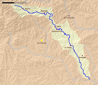
Both merge near Fort McKavett to form the San Saba River, which flows another 140 miles east/northeast until it drains into the Colorado River east of the city of San Saba.
A major tributary is Brady Creek, which is 90 miles long and parallels the path of the San Saba to the north. [1]
The river was named by the governor of Spanish Texas, Juan Antonio Bustillo y Ceballos, in 1732. He called it Río de San Sabá de las Nueces ("River of Saint Sabbas of the Walnuts"), because he and his troops had arrived December 5, the feast day of St. Sabbas (439–532), a major figure of early Christian monastic life.
Santa Cruz de San Sabá Mission was established on the river in 1757. [2]

As of 2013 [update] , the San Saba River was an overappropriated stream with large stretches of the river dry, depriving downstream riparian users of water, while upstream flow was being diminished by pumping of aquifers hydrologically connected to the stream. [3]

San Saba County is a county located on the Edwards Plateau in western Central Texas, United States. As of the 2020 census, its population was 5,730. Its county seat is San Saba. The county is named after the San Saba River, which flows through the county.

McCulloch County is a county located on the Edwards Plateau in the U.S. state of Texas. At the 2020 census, its population was 7,630. Its county seat is Brady. The county was created in 1856 and later organized in 1876. It is named for Benjamin McCulloch, a famous Texas Ranger and Confederate general.

The Colorado River is an approximately 862-mile-long (1,387 km) river in the U.S. state of Texas. It is the 11th longest river in the United States and the longest river with both its source and its mouth within Texas.

The Trinity River is a 710-mile (1,140 km) river, the longest with a watershed entirely within the U.S. state of Texas. It rises in extreme northern Texas, a few miles south of the Red River. The headwaters are separated by the high bluffs on the southern side of the Red River.

Little River is a 60-mile (97 km) river in Tennessee which drains a 380-square-mile (980 km2) area containing some of the most spectacular scenery in the southeastern United States. The first 18 miles (29 km) of the river are all located within the borders of the Great Smoky Mountains National Park. The remaining 42 miles (68 km) flow out of the mountains through Blount County to join the Tennessee River at Fort Loudon Lake in Knox County.

Lavaca Bay is a northwestern extension of the Matagorda Bay system found mostly in Calhoun County, Texas, United States. The ports of Port Lavaca and Point Comfort have been established on the bay, and are the main areas of human habitation. Linnville was located on the bay until its abandonment after the Great Raid of 1840, and the major port of Indianola was found near the confluence with the main Matagorda Bay, until the town's final destruction following the massive hurricane of 1886. Smaller communities include Olivia, Alamo Beach and Magnolia Beach. Lavaca Bay is approximately 82 miles (130 km) northeast of Corpus Christi, about 121 miles (190 km) southwest of Houston, and 145 miles (230 km) southeast of San Antonio.
The Little River is a river in Central Texas in the Brazos River watershed. It is formed by the confluence of the Leon River and the Lampasas River near Little River, Texas in Bell County. It flows generally southeast for 75 miles (121 km) until it empties into the Brazos River about 5 miles (8.0 km) southwest of Hearne, at a site called Port Sullivan in Milam County. The Little River has a third tributary, the San Gabriel River, which joins the Little about 8 miles (13 km) north of Rockdale and five miles southwest of Cameron. Cameron, the county seat of Milam County and the only city of any significant size on the Little River, was established in 1846.
Cibolo Creek is a stream in South Central Texas that runs approximately 96 miles (154 km) from its source at Turkey Knob near Boerne, Texas, to its confluence with the San Antonio River in Karnes County. The creek is a tributary of the San Antonio River, at the easternmost part of its watershed.

Sabas (439–532), in Church parlance Saint Sabas or Sabbas the Sanctified, was a Cappadocian Greek monk, priest, grazer and saint, who was born in Cappadocia and lived mainly in Palaestina Prima. He was the founder of several convents, most notably the one known as Mar Saba, in Palestine. The saint's name is derived from Imperial Aramaic: סַבָּא Sabbāʾ "old man".
San Idelfonso Creek is a small stream of water located in Webb County, Texas which runs through Laredo, Texas. The creek is formed within east Laredo and runs southwest for 8 miles until connecting to the Rio Grande. San Ildefonso Creek was dammed in east Laredo to form San Ildefonso Creek Lake, the second largest Lake in Laredo. The terrain surrounding the creek is mostly clay and sandy loams. The vegetation surrounding the creek is mostly made up of mesquite, cacti, chaparral, hardwoods and grasses. San Idelfonso Creek crosses two major highways in Laredo, Texas among them are: Texas State Highway 359 and United States Route 83
San Ygnacio Creek is a small stream of water located in Webb County, Texas which runs through Laredo, Texas. The creek is formed 11 miles northwest of Laredo, Texas and runs southwest for 12 mi (19 km) until the creek connects to the Lake Casa Blanca. The terrain surrounding the creek is mostly clay. The vegetation surrounding the creek is mostly made up of mesquite, cacti, and grasses. San Ygnacio Creek does not cross any major highway.
Brushy Creek is a tributary of the San Gabriel River in Texas that flows east for 69 miles.

Caney Creek (Matagorda Bay) is a river in Texas that begins northwest of Wharton, flows generally southeast, and empties into the Gulf of Mexico near Sargent. The major waterway to the west is the Colorado River while the next major waterway to the east is the San Bernard River.

Yegua Creek is a river in Central Texas and is part of the Brazos River drainage basin. Yegua Creek forms in Lee County at the confluence of the Middle Yegua Creek and East Yegua Creek about three miles west of Somerville Lake. It is the primary tributary to form Somerville Lake. The Yegua flows east and becomes part of the Burleson County line for about 31 miles and then joins the Brazos River in southeastern Washington County. The Yegua below the Somerville Dam is a slow-moving, gentle river but is nevertheless used for some mild recreational canoeing and kayaking.
Juan Antonio Bustillo y Ceballos (Zevallos) was a soldier and politician who served as governor of Province of Texas (1730–1734) and Coahuila, New Spain (1754–1756). He also served as alcalde ordinario in Mexico City.
The Pinta Trail is a historic trail in Central Texas that was first traveled by indigenous tribes, and later explorers, settlers, soldiers, and travelers. The 19th-century Germans who settled the Texas Hill Country used part of the Pinta Trail on their journey northward from New Braunfels to found Fredericksburg. A historic battle between a Texas Rangers patrol and a band of Comanches is often said to have occurred near a ford where the Pinta Trail crossed the Guadalupe River.
Leon Creek is a tributary stream of the Medina River, in Bexar County, Texas.
Live Oak Creek, a stream with its source in Reagan County, Texas at 31°10′45″N101°42′01″W at an elevation of 2938 feet, that runs southward to its mouth at an elevation of 2001 feet on the Pecos River in Crockett County, Texas.

The Little Red River is an intermittent stream about 30 mi (48 km) long, formed at the confluence of the North Prong and South Prong Little Red River in Briscoe County, Texas, and flowing east-northeastward to join the Prairie Dog Town Fork Red River in Hall County, Texas.
31°15′12″N98°35′44″W / 31.25333°N 98.59556°W
| | This article related to a river in Texas is a stub. You can help Wikipedia by expanding it. |