| Rincon Bayou | |
|---|---|
| Location | |
| Country | United States |
| State | Texas |
| County | Nueces County |
| Physical characteristics | |
| Mouth | |
• location | Nueces Bay |
• coordinates | 27°52′16″N97°30′58″W / 27.871°N 97.516°W Coordinates: 27°52′16″N97°30′58″W / 27.871°N 97.516°W |
Rincon Bayou is in the Nueces River delta, and located northwest of Corpus Christi. The Rincon Bayou is subject to freshwater inundation following seasonal rainfall events farther inland along the Nueces River. The freshwater inundation provides the bayou with nutrients and enough fresh water to remove the saline water from the estuarine system. In 1984, though, the United States Bureau of Reclamation built a dam along the Frio River to create Choke Canyon Reservoir, which has consequently caused a decrease in freshwater flow into the Rincon Bayou. This decrease has affected the wetland plant and macroinvertebrate communities. The hypersaline condition makes it difficult for plants to produce seeds and for the seeds to germinate. As part of an effort for the Rincon Bayou–Nueces Marsh Wetlands Restoration and Enhancement Project, the Bureau of Reclamation has created a channel between the Nueces River and the Rincon Bayou. It is located just east of US 77 and extends 900 ft to the bayou. The purpose of the channel is to increase the freshwater inflow into the bayou. A second channel was cut within the bayou in an effort to increase the freshwater flow to an area dominated by sand and mud flats. The increase in freshwater flow should help re-establish the vegetative community.

A swamp is a forested wetland. Swamps are considered to be transition zones because both land and water play a role in creating this environment. Swamps vary in size and are located all around the world. The water of a swamp may be fresh water, brackish water, or seawater. Freshwater swamps form along large rivers or lakes where they are critically dependent upon rainwater and seasonal flooding to maintain natural water level fluctuations. Saltwater swamps are found along tropical and subtropical coastlines. Some swamps have hammocks, or dry-land protrusions, covered by aquatic vegetation, or vegetation that tolerates periodic inundation or soil saturation. The two main types of swamp are "true" or swamp forests and "transitional" or shrub swamps. In the boreal regions of Canada, the word swamp is colloquially used for what is more correctly termed a bog, fen, or muskeg. Some of the world's largest swamps are found along major rivers such as the Amazon, the Mississippi, and the Congo.

A wetland is a distinct ecosystem that is flooded by water, either permanently or seasonally, where oxygen-free processes prevail. The primary factor that distinguishes wetlands from other land forms or water bodies is the characteristic vegetation of aquatic plants, adapted to the unique hydric soil. Wetlands play a number of functions, including water purification, water storage, processing of carbon and other nutrients, stabilization of shorelines, and support of plants and animals. Wetlands are also considered the most biologically diverse of all ecosystems, serving as home to a wide range of plant and animal life. Whether any individual wetland performs these functions, and the degree to which it performs them, depends on characteristics of that wetland and the lands and waters near it. Methods for rapidly assessing these functions, wetland ecological health, and general wetland condition have been developed in many regions and have contributed to wetland conservation partly by raising public awareness of the functions and the ecosystem services some wetlands provide.

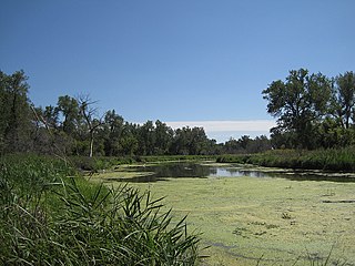
A marsh is a wetland that is dominated by herbaceous rather than woody plant species. Marshes can often be found at the edges of lakes and streams, where they form a transition between the aquatic and terrestrial ecosystems. They are often dominated by grasses, rushes or reeds. If woody plants are present they tend to be low-growing shrubs, and then sometimes called carrs. This form of vegetation is what differentiates marshes from other types of wetland such as swamps, which are dominated by trees, and mires, which are wetlands that have accumulated deposits of acidic peat.

A salt marsh or saltmarsh, also known as a coastal salt marsh or a tidal marsh, is a coastal ecosystem in the upper coastal intertidal zone between land and open saltwater or brackish water that is regularly flooded by the tides. It is dominated by dense stands of salt-tolerant plants such as herbs, grasses, or low shrubs. These plants are terrestrial in origin and are essential to the stability of the salt marsh in trapping and binding sediments. Salt marshes play a large role in the aquatic food web and the delivery of nutrients to coastal waters. They also support terrestrial animals and provide coastal protection.

A tidal creek, tidal channel, or estuary is the portion of a stream that is affected by ebb and flow of ocean tides, in the case that the subject stream discharges to an ocean, sea or strait. Thus this portion of the stream has variable salinity and electrical conductivity over the tidal cycle, and flushes salts from inland soils. Tidal creeks are characterized by slow water velocity resulting in buildup of fine, organic sediment in wetlands. Creeks may often be a dry to muddy channel with little or no flow at low tide, but with significant depth of water at high tide. Due to the temporal variability of water quality parameters within the tidally influenced zone, there are unique biota associated with tidal creeks which are often specialised to such zones. Nutrients and organic matter are delivered downstream to habitats normally lacking these, while the creeks also provide access to inland habitat for salt-water organisms.
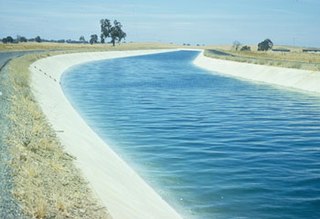
The Delta–Mendota Canal is a 117 mi (188 km) aqueduct in central California, United States. The canal was designed and completed in 1951 by the U.S. Bureau of Reclamation as part of the Central Valley Project to supply freshwater to users downstream of the San Joaquin River. Freshwater is diverted into the Madera Canal and Friant-Kern Canal at Friant Dam.

The Colorado River Delta is the region where the Colorado River flows into the Gulf of California in eastern Mexicali Municipality in the north of the state of Baja California in northwestern-most Mexico. The delta is part of a larger geologic region called the Salton Trough. Historically, the interaction of the river's flow and the ocean's tide created a dynamic environment, supporting freshwater, brackish, and saltwater species. Within the delta region, the river split into multiple braided channels and formed a complex estuary and terrestrial ecosystems. The use of water upstream and the accompanying reduction of freshwater flow has resulted in the loss of most of the wetlands of the area, as well as drastic changes to the aquatic ecosystems. However, a scheme is currently in place which aims to rejuvenate the wetlands by releasing a pulse of water down the river delta.

The Atchafalaya Basin, or Atchafalaya Swamp, is the largest wetland and swamp in the United States. Located in south central Louisiana, it is a combination of wetlands and river delta area where the Atchafalaya River and the Gulf of Mexico converge. The river stretches from near Simmesport in the north through parts of eight parishes to the Morgan City southern area.

Located in northern California the Suisun Marsh has been referred to as the largest brackish water marsh on west coast of the United States of America. The marsh land is part of the San Francisco Bay tidal estuary, and subject to tidal ebb and flood. The marsh is home to many species of birds and other wildlife, and is formed by the confluence of the Sacramento and San Joaquin rivers between Martinez and Suisun City, California and several other smaller, local watersheds. Adjacent to Suisun Bay, the marsh is immediately west of the legally defined Sacramento-San Joaquin Delta as well as part of the San Francisco Bay estuary.

Corpus Christi Bay is a scenic semi-tropical bay on the Texas coast found in San Patricio and Nueces counties, next to the major city of Corpus Christi. It is separated from the Gulf of Mexico by Mustang Island, and is fed by the Nueces River and Oso Creek from its western and southern extensions, Nueces Bay and Oso Bay. The bay is located approximately 136 miles (219 km) south of San Antonio, and 179 miles (288 km) southwest of Houston.

The Nimbus Dam is a base load hydroelectric dam on the American River near Folsom, California. Approximately 8,700 acre feet (10,700 dam3) of water is retained by the dam. It is responsible for the impoundment of water from the American River to create the Lake Natoma reservoir. The dam stands 87 feet and spans 1,093 feet. The Nimbus powerplant consists of two generators. Each generator produces enough electrical power to power over 200,000 100-watt light bulbs, about 15,500 kilowatts of electrical power. Nimbus Dam consists of 18 radial gates, each with their own gate bays. These 18 gates today are the ones that were completed in 1955 along with the rest of the dam. Of the eighteen gates, four of them have had their coating system replaced. This protects the gates from a faster rate of corrosion. The other fourteen gates have the original coating.

Caernarvon is an unincorporated community in St. Bernard Parish, Louisiana, United States. The name of the community is from a plantation originally located here. The plantation's name is widely believed to be from a similarly named town and castle in Wales. Names of antebellum plantations in the American South were often reflective of European roots and aspirations of grandeur; two upriver Mississippi River plantations, Nottoway near White Castle, Louisiana, and Sans Souci near Osceola, Arkansas, are two examples of this tradition.
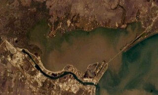
Nueces Bay is a northwestern extension of Corpus Christi Bay in the San Patricio and Nueces Counties of Texas. The bay is fed by the Nueces River, forming a natural estuary, which renders it ecologically and economically vital to the surrounding area. It serves as a habitat for the propagation of fish and shellfish, which sustain diverse species of birds and other wildlife. The bay is threatened by pollution from the heavy industry on its southern shore, which prevents oyster farming. Petrochemical production and oil are important to the surrounding economies of the major settlements of Corpus Christi and Portland, found on the eastern shore and connected by the Nueces Bay Causeway at the bay's confluence with Corpus Christi Bay.
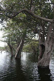
Igapó is a word used in Brazil for blackwater-flooded forests in the Amazon biome. These forests and similar swamp forests are seasonally inundated with freshwater. They typically occur along the lower reaches of rivers and around freshwater lakes. Freshwater swamp forests are found in a range of climate zones, from boreal through temperate and subtropical to tropical. In the Amazon Basin of Brazil, a seasonally whitewater-flooded forest is known as a várzea, which is similar to igapó in many regards; the key difference between the two habitats is in the type of water that floods the forest.

Riparian-zone restoration is the ecological restoration of riparian-zonehabitats of streams, rivers, springs, lakes, floodplains, and other hydrologic ecologies. A riparian zone or riparian area is the interface between land and a river or stream. Riparian is also the proper nomenclature for one of the fifteen terrestrial biomes of the earth; the habitats of plant and animal communities along the margins and river banks are called riparian vegetation, characterized by Aquatic plants and animals that favor them. Riparian zones are significant in ecology, environmental management, and civil engineering because of their role in soil conservation, their habitat biodiversity, and the influence they have on fauna and aquatic ecosystems, including grassland, woodland, wetland or sub-surface features such as water tables. In some regions the terms riparian woodland, riparian forest, riparian buffer zone, or riparian strip are used to characterize a riparian zone.
A slough is a wetland, usually a swamp or shallow lake, often a backwater to a larger body of water. Water tends to be stagnant or may flow slowly on a seasonal basis.
Environmental flows can be broken down into instream flow, freshwater inflow, and outflow, as shown in the depiction below. Instream flow is the freshwater water flowing in rivers or streams. Freshwater inflow is the freshwater that flows into an estuary. Outflow is the flow from an estuary to the ocean. This article's focus is upon freshwater inflow.

The Great Darling Anabranch, commonly called the Darling Anabranch, is an anabranch and ancestral path of the Darling River in the lower Murray-Darling basin in the Far West and Riverina regions of New South Wales, Australia.

The Powers Butte Wildlife Area is located along the east side of the Gila River, about twenty miles north of Gila Bend, in Maricopa County, Arizona. It was founded in 1982 and spans 1,120 acres.