
Bellingham is the most populous city in, and county seat of Whatcom County in the U.S. state of Washington. It lies 21 miles (34 km) south of the U.S.–Canada border and in between Vancouver, British Columbia and Seattle.

Kendall is a census-designated place (CDP) in Whatcom County, Washington, United States. The population was 191 at the 2010 census.
Sehome, also called Sehome Hill, is a forested hill in Bellingham, Washington. The Sehome Hill Arboretum is an 175.5-acre (71.0-hectare) park of second growth forest is located on the hill, adjacent to the campus of Western Washington University. Though called an arboretum, the hilly expanse atop Sehome is not consciously planted as an exhibit of tree species, but naturally wooded and rich in the plant species typical of the region. The arboretum is jointly managed by both the university and the city. Its care is overseen by the Sehome Arboretum Board of Governors, composed of city employees, university employees, university students, and city residents. The park offers students and city dwellers over 5 miles (8 km) of public trails for walking and running and, in some areas, bicycling. Unique features of the park include an 80-foot (24 m) wooden observation tower atop Sehome, with aerial views of Bellingham Bay to the south. There is also a large tunnel, hand cut into rock in 1923, originally used for car traffic in the early 1900s. Its tall, thin shape shows its creation for cars like Model T Fords of the day. Cars are no longer allowed in the tunnel and it is part of a trail along which hikers can walk.


Padilla Bay is a bay located in the U.S. state of Washington, between the San Juan Islands and the mainland. Fidalgo Island and Guemes Island lie to the west of Padilla Bay. Guemes Channel, between the islands, connects Padilla Bay to Rosario Strait. Samish Island lies to the north of Padilla Bay, beyond which is Samish Bay and Bellingham Bay.

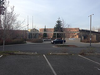
Sehome High School is a public school in Bellingham, Washington, located approximately 90 miles (140 km) north of Seattle and 52 miles (84 km) south of Vancouver, British Columbia. The school serves students mainly from the western and southwestern sections of the City of Bellingham and is a part of the Bellingham School District.

KUGS is a college radio station in Bellingham, Washington, United States, owned by Western Washington University (WWU). It is managed by WWU students and broadcasts from studios in the Viking Union on the WWU campus in Bellingham and a transmitter atop Sehome Hill.

Whatcom Falls Park is a 241-acre (0.98 km2) park in Bellingham, Washington, United States. The falls are on Whatcom Creek, which leads from Lake Whatcom to Bellingham Bay. The park has four sets of waterfalls and several miles of well maintained walking trails.
The Bellingham Railway Museum was a nonprofit museum located in downtown Bellingham, Washington, USA, that displayed a pictorial and text history of railroad traffic in Bellingham and Whatcom/Skagit Counties, as well as a large electric model railroad, an exhibit of railroad lanterns, and a train simulator based on Microsoft Train Simulator software. A research library was also hosted. It opened in 2003 and was volunteer operated until its permanent closure in June of 2020 due to a loss of income during the COVID-19 pandemic.

Bellingham Bay is a bay of the Salish Sea located in Washington State in the United States. It is separated from the Strait of Georgia on the west by the Lummi Peninsula, Portage Island, and Lummi Island. It is bordered on the east by Bellingham, Washington, to the south-east by the Chuckanut Mountains, and to the south by Samish Bay. The Nooksack River empties into the bay, as does Whatcom Creek.

The Chuckanut Mountains, or Chuckanuts, are located on the northern Washington state coast of the Salish Sea, just south of Bellingham, Washington. Being a part of the Cascade Range, they are the only place where the Cascades come west down to meet the sea. The Chuckanuts are considered to be a part of the Puget Lowland Forest Ecoregion.

KPUG is a sports radio station located and licensed in Bellingham, Washington, transmitting from an antenna located off Sunset Drive. KPUG is operated by the Cascade Radio Group, owned by Saga Communications. The majority of local sports taking place in and around Whatcom County are broadcast on KPUG.

The Hamilton Building also known as The Flatiron Building of Bellingham and the Bellingham Bay Furniture Building was the first "skyscraper" in Bellingham. Built in 1908 for Talifero Simpson Hamilton's growing Bellingham Bay (B.B.) Furniture Company established in 1889, the building cost $100,000 and used thirty-five thousand barrels of cement along with 200,000 pounds of steel. Due to its triangular shape and resemblance to the Fuller Building in New York, the building instantly garnered the flatiron nickname. It was Bellingham's tallest structure until 1926.
Squalicum High School is a public school in Bellingham, Washington, United States, and is part of the Bellingham School District. The school serves the northeast population of Bellingham, including the area surrounding Lake Whatcom. Squalicum takes students from Shuksan Middle School and Whatcom Middle School.
Sehome Hill Arboretum is a park on Sehome Hill in Bellingham, Washington.
The history of Bellingham, Washington, as it is now known, begins with the settling of Whatcom County in the mid-to-late 19th century.
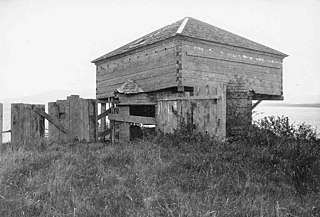
Fort Bellingham (1856–1860) was a U.S. Army fort built to prevent attacks by Indians from Canada and from Russian territory, on the bayside villages of Fairhaven, Sehome and Whatcom.
Chuckanut Bay is a crescent-shaped bay about three miles (4.8 km) long in southwestern Whatcom County, directly south of Bellingham, Washington, United States. The bay was formed along the axis of a plunging syncline during the formation of the Chuckanut Mountains. It is situated on the east shore of the Salish Sea at the southeast end of Bellingham Bay. The bay was named Puerto del Socorro by Lieut. Juan Francisco de Eliza in 1791. The present name was chosen by Capt. Henry Roeder on December 1, 1852. The name 'Chuckanut' is derived from a native word for "Long beach far from a narrow entrance" Prominent natural features include Pleasant Bay located south of Chuckanut Bay, Mud Bay to the north and Chuckanut Island and Chuckanut Rocks to the west. Other natural features include Teddy Bear Cove, Governors Point and Clark Point. The most prominent creeks that drain into the bay are Chuckanut Creek and Fragrance Lake Outlet. The bay is home to interesting tafoni formations found in the area.

The steamship General Frisbie was a wooden two-deck passenger ship built in 1900, named after John B. Frisbie. She was designed for use as a ferry between Vallejo and San Francisco. The steamer was successful in that role and was the fastest ship on the route when she began service. Improved roads, bridges, and automobiles reduced demand for ferry service in the Bay Area, and newer ships were optimized for transporting cars, so General Frisbie was retired in the late 1920s.
The Black Diamond Coal Mining Company was formed in 1861, consolidating the Cumberland and Black Diamond coal mines in the region of Mount Diablo, in Contra Costa County, California. During its years of operation as a mining company, it established three towns: Nortonville, California, Southport, Oregon, and Black Diamond, Washington. The company's mines in California and its settlement of Nortonville later became part of the Black Diamond Mines Regional Park and a California Historical Landmark. Several railroad lines were built in California and Washington to support the company's mines, and the company operated numerous ships to transport its coal. As the mines played out and petroleum became the more common source of energy, the company closed its mines and transitioned into real estate as the Southport Land and Commercial Company.