Severe thunderstorm watch

Last updated
Map of average annual severe thunderstorm watches in the United States between 1999 and 2008.
Legend:
.mw-parser-output .col-begin{border-collapse:collapse;padding:0;color:inherit;width:100%;border:0;margin:0}.mw-parser-output .col-begin-small{font-size:90%}.mw-parser-output .col-break{vertical-align:top;text-align:left}.mw-parser-output .col-break-2{width:50%}.mw-parser-output .col-break-3{width:33.3%}.mw-parser-output .col-break-4{width:25%}.mw-parser-output .col-break-5{width:20%}@media(max-width:720px){.mw-parser-output .col-begin,.mw-parser-output .col-begin>tbody,.mw-parser-output .col-begin>tbody>tr,.mw-parser-output .col-begin>tbody>tr>td{display:block!important;width:100%!important}.mw-parser-output .col-break{padding-left:0!important}}
.mw-parser-output .legend{page-break-inside:avoid;break-inside:avoid-column}.mw-parser-output .legend-color{display:inline-block;min-width:1.25em;height:1.25em;line-height:1.25;margin:1px 0;text-align:center;border:1px solid black;background-color:transparent;color:black}.mw-parser-output .legend-text{}
<0.1
<3
<6
<9
<12
<15
<18
<21
>21 Annual severe thunderstorm watch frequency in the United States.svg
Map of average annual severe thunderstorm watches in the United States between 1999 and 2008.
Legend:

A severe thunderstorm watch (SAME code: SVA) is a statement issued by weather forecasting agencies to advise the public that atmospheric conditions in a given region may lead to the development of severe thunderstorms within (or near) the region over several hours. The criteria for issuing a watch varies from country to country and may also include torrential rainfall and tornadoes. A watch may also be issued several hours ahead of the arrival of a mature and organized complex of storms, such as a mesoscale convective system.

Contents

A severe thunderstorm watch, like a tornado watch, is not to be confused with a warning. A watch encourages the public to remain vigilant—to be on the watch, so to speak—for later severe weather. An area under a watch may even experience deceptively fair weather with few clouds before thunderstorms appear.

In the United States, severe thunderstorm watches are issued by the National Weather Service Storm Prediction Center in Norman, Oklahoma. [1] [2]

Definition

A severe thunderstorm watch indicates that atmospheric conditions observed in and close to the watch area have created a significant risk for the development and intensification of convective thunderstorms that could exceed regional severe criterion, and are normally issued in advance of the onset of severe weather. (The criteria for thunderstorms to be classified as severe varies by country; e.g., in the United States, severe thunderstorms must produce winds exceeding 58 mph [93 km/h], and/or hailstones larger than one inch [2.5 cm] in diameter, and/or one or more tornadoes.) Generally (but not always), thunderstorms that develop within the watch area may contain large hailstones, intense straight-line winds, intense lightning, torrential rainfall and/or flash flooding caused by high rainfall accumulations. Depending on storm cell intensity, severe thunderstorms can cause damage to structures or vehicles; impairment of vehicle and pedestrian travel; flooding to streets, populated neighborhoods, farmlands and other areas of poor drainage; and in extreme cases, injury or possible fatality to people and animals exposed outdoors (from either repeated hail-induced blunt trauma, wind-generated debris or intense flooding). [3] [4]

If severe weather actually does occur, a severe thunderstorm warning or tornado warning would then be issued. Residents and travelers in the watch area are advised to immediately undertake safety preparations ahead of the arrival of severe weather. A watch is not required for a thunderstorm- or other hydrological-based weather warning to be issued; severe thunderstorm warnings are often issued when a severe thunderstorm watch is not active (i.e., when a tornado watch is active or, less frequently, if severe convective storms are not expected to be of broad enough coverage to require a watch).

While a severe thunderstorm watch does not nominally imply the probability for tornadoes, if modest wind shear and storm-level helicity is conducive for a marginal tornado threat within the convective environment, storm cells that develop within the proximate severe thunderstorm watch area can occasionally exhibit mesocyclonic rotation at the cloud base and may spawn tornadoes if advanced tornadogenesis occurs. An existing severe thunderstorm watch, or merely a portion of it, can also be upgraded to a tornado watch, if conditions that were originally considered marginally conducive if at all for tornadic development have evolved to permit a greater risk of tornado formation; conversely, a section or the entirety of an existing tornado watch area can be replaced by a severe thunderstorm watch, if conditions are no longer considered conducive for tornadogenesis. Straight-line winds in severe thunderstorms created by strong downdrafts, however, can produce serious structural damage as severe as a lower-category tornado or hurricane over a path comparatively wider than a tornado. [4]

When a severe thunderstorm watch is issued, people within the region of expected severe weather risk are advised to monitor conditions ahead of the developing weather situation; review thunderstorm safety precautions in the event they must seek immediate shelter; and use local broadcast media, weather radio, weather app alert notifications and/or SMS notifications to receive warnings and updated storm information. [5]

Regional basis

United States

In the United States, severe thunderstorm watches are issued by the Storm Prediction Center (SPC), a national guidance center of the National Weather Service (NWS) branch of the National Oceanic and Atmospheric Administration (NOAA), for areas of the lower 48 states where atmospheric conditions favor the development of convective thunderstorm activity reaching severe criteria. Although seldom issued in these states, responsibilities for issuing severe thunderstorm watches covering Alaska and Hawaii are respectively handled by local NWS forecast offices in Fairbanks, Anchorage and Juneau, Alaska, and Honolulu, Hawaii. [4] [6] Watches are typically valid for six to nine hours (extending if necessary as long as 12 hours during unusually steady-state or slow-moving severe weather events) after the time of issuance, and are intended to precede the first report of severe hail or wind by 45 minutes to one hour. SPC watch boxes—termed because the approximate watch area is represented as a quadrilateral for aviation purposes—are usually outlined in the approximate delineation of x miles north and south, or east and west, or either side of a line (perpendicular to the center line) from y miles direction of city, state, to z miles another direction of another city, state (e.g., "50 miles either side of a line from 10 miles northeast of Columbia, South Carolina to 15 miles south-southwest of Montgomery, Alabama"). Geographic coverage of severe thunderstorm watches (which ranges from 20,000–40,000 square miles [52,000–104,000 km2] on average, encompassing portions of one or more states) vary based on the size of the land area under threat, the duration of severe weather risk, and the forward motion of the parent storm system and associated surface boundaries. [7] [8]

In situations where atmospheric conditions will support the production of very destructive straight-line winds and hail from the convective activity, the intensified wording "particularly dangerous situation" (PDS) can be added into the watch product. PDS severe thunderstorm watches usually suggest conditions over the approximate area present a widespread threat of destructive hail greater than two inches (5.1 cm) in diameter and winds greater than 75 mph (121 km/h) being generated from the thunderstorm convection, or that downstream conditions favor the development and intensification of a bow echo or derecho moving at 55 mph (89 km/h) or faster. The inclusion of PDS wording (more commonly used for tornado watches in areas where the environment supports the development of strong to violent tornadoes) is rare for severe thunderstorm watches since the tornado threat, in comparison to the much higher threat of extreme wind or hail, must remain low enough to where a standard (non-PDS) tornado watch is not warranted. [8] [9]

SPC meteorologists utilize WarnGen software integrated into the National Centers Advance Weather Interactive Processing System (N-AWIPS) and/or the SPC Product Generator (PRODGEN) to generate the watch statement, which is disseminated through various communication routes accessed by the media and various agencies, on the internet, to NOAA satellites, and over NOAA Weather Radio. [7] The terms "blue box" and "yellow box," often used in parlance within the meteorological community, refer to the coloring assigned to severe thunderstorm watch boxes for hazard maps used by the Storm Prediction Center and the National Weather Service; coloring used by local television outlets to highlight severe thunderstorm watches sometimes vary (in many cases, severe weather alert displays used by many local television stations usually reserve yellow as a highlighter for severe thunderstorm warnings, and blue as a highlighter for severe thunderstorm watches).

The Storm Prediction Center, in conjunction with local NWS Weather Forecast Offices, issues component watch products to communicate the approximate area, primary hazards and other pertinent information about the severe thunderstorm watch to the public, NOAA meteorologists, emergency management and aviation personnel. The graphical and text Public Watch products—in addition to outlining the approximate affected area, valid time, meteorological and aviation discussions, and other pertinent information—includes language specifying the forecast severe weather threat (e.g., "widespread large hail and isolated very large hail events to 3 inches in diameter likely, scattered damaging wind gusts to 70 mph likely, a tornado or two possible") in the primary hazards list. The Watch Probability Table describes probabilities for all modes of severe weather, including probabilities of 10 or more severe wind or hail events and one or more reports of winds exceeding 65 knots (75 mph) or hailstones exceeding two inches (5.1 cm). (Typically, the minimum event probabilities for a severe thunderstorm watch issuance require an ~30% chance of 10 or more wind and hail reports and, for PDS watches, a 70% chance of one or more reports of >65 kt winds and/or >2-inch hail within the watch area over the valid time period.) [7]

The SPC produces two separate products listing all counties or equivalent subdivisions (parishes, independent cities, and coastal marine zones) included in the broader watch area: Watch County Lists (WCL), which are produced internally preceding the watch issuance for collaborative use with local NWS offices to outline counties and equivalent subdivisions being proposed for inclusion in the watch, and Watch Outline Update (WOU) messages, a public list of the determined watch subdivisions published upon the initial severe thunderstorm watch issuance. [7] [10] Local NWS offices concurrently issue Watch County Notification (WCN) messages that list subdivisions within their designated area of responsibility that the office has considered to be in the initial watch; WCN messages—which the SPC uses as the basis for their Watch Outline Update product—are updated to denote changes to the watch by local WFOs, which are provided responsibility for adding or removing counties/subdivisions from the watch, extending its time of expiration, or cancelling the watch entirely if conditions no longer support a severe weather threat (if atmospheric conditions have become less conducive to form severe thunderstorms or were insufficient for severe weather development compared to earlier forecast analysis). The SPC updates Watch Outline Updates at least on an hourly basis to incorporate changes made by the accordant WFOs in their Watch County Notification messages. [7] [10] [9]

The SPC issues Watch Status Messages to designate areas considered to have a continuing severe weather threat, based primarily on the position of surface features (such as cold fronts and drylines)—and the NWS offices decide what counties to remove from the watch (the local offices will almost always follow the SPC recommendation on the status messages). [7] [10] If conditions are no longer favorable for severe convective thunderstorms in the watch area, the severe thunderstorm watch may be cancelled outright; occasionally, a severe thunderstorm watch, if not merely a section of it, may be replaced by a tornado watch should conditions that were originally forecast to be conducive for non-tornadic severe thunderstorms evolve to allow an increased possibility of tornado formation, and likewise may replace a tornado watch if conditions for tornadogenesis are no longer considered favorable. If no convective development or reported severe weather occurs, this leads to a severe thunderstorm watch "bust", which can factor into determinations by the SPC and National Weather Service offices on whether to cancel the watch.

Because the Storm Prediction Center and local National Weather Service WFOs each have roles in the watch issuance process, the subdivisions listed in the Watch Outline Update and Watch County Notification products will sometimes differ from the outlined watch box area, including subdivisions located outside the outlined quadrilateral; however the local Weather Forecast Office is tasked with determining which counties should be included in or, in lieu of a new downstream watch, added to the designated watch area. The WFOs monitoring their sector of the watch area can also consult, via conference call, with the Storm Prediction Center to relay and determine locally dictated changes to the severe thunderstorm watch, regarding replacement of the watch and extensions of time and areal coverage if conditions warrant. [7] [10]

Canada

In Canada, Environment and Climate Change Canada (ECCC) issues severe thunderstorm watches through regional Meteorological Service (MSC) offices based in Vancouver, Edmonton, Winnipeg, Toronto, Montreal and Dartmouth. [11] [12] [13] Unlike the box/subdivision structure of watches issued by the U.S. Storm Prediction Center, severe thunderstorm watches issued by the Meteorological Service are issued strictly for groups of census subdivisions, often covering a total area that is relatively smaller than severe thunderstorm watches in the U.S.). Watches are disseminated to the public through broadcast and online media outlets (including local television stations and The Weather Network/MétéoMédia), and Weatheradio Canada; depending on regional office discretion, the watch may require activation of the National Public Alerting System (Alert Ready) (French : Système national d'alertes à la population [En Alerte]) and feeding provincial alerting systems (such as Alberta Emergency Alert and SaskAlert) to distribute the alert to local broadcast media and cellular phones.

Philippines

In the Philippines, the Philippine Atmospheric, Geophysical and Astronomical Services Administration (PAGASA), through its regional services divisions, issues thunderstorm watches to alert regions and/or provinces of thunderstorm development within a period of twelve hours. [14] Watches are disseminated to the public through terrestrial television and radio stations, [15] and online media outlets. [14]

Example products

Example of a severe thunderstorm watch

SEL0     URGENT - IMMEDIATE BROADCAST REQUESTED    Severe Thunderstorm Watch Number 300    NWS Storm Prediction Center Norman OK    235 PM EDT Wed Jun 24 2020     The NWS Storm Prediction Center has issued a     * Severe Thunderstorm Watch for portions of       southern Alabama      western Florida Panhandle      southwestern Georgia      Coastal Waters     * Effective this Wednesday afternoon and evening from 235 PM      until 1000 PM EDT.     * Primary threats include...      Scattered damaging wind gusts to 70 mph possible      A tornado or two possible     SUMMARY...Numerous thunderstorms will continue developing over    southern portion of the Gulf Coast states this afternoon. Multicell    and some marginal supercell structures are likely with damaging wind    the main threat, and a tornado or two possible.     The severe thunderstorm watch area is approximately along and 75    statute miles north and south of a line from 20 miles north    northwest of Mobile AL to 55 miles southeast of Macon GA. For a    complete depiction of the watch see the associated watch outline    update (WOUS64 KWNS WOU0).     PRECAUTIONARY/PREPAREDNESS ACTIONS...     REMEMBER...A Severe Thunderstorm Watch means conditions are    favorable for the development of severe weather, including large hail and     damaging winds in and close to the watch area.    Persons should be on the lookout for rapidly changing     weather conditions and listen for later statements and possible    warnings. Severe thunderstorms can and occasionally do produce    tornadoes.     &&     AVIATION...A few severe thunderstorms with hail surface and aloft to    1 inch. Extreme turbulence and surface wind gusts to 60 knots. A few    cumulonimbus with maximum tops to 500. Mean storm motion vector    24035.     ...Dial 

Example of Severe Thunderstorm Watch with PDS wording

Severe Thunderstorm Watch Number 260 (2024).gif

HazardTornadoesEF2+ TornadoesSevere Wind65 kt+ WindSevere Hail2"+ Hail
LikelihoodModerateLowHighHighHighHigh
SEL0  URGENT - IMMEDIATE BROADCAST REQUESTED Severe Thunderstorm Watch Number 260 NWS Storm Prediction Center Norman OK 235 PM CDT Sun May 19 2024  The NWS Storm Prediction Center has issued a  * Severe Thunderstorm Watch for portions of    Western and Central Kansas   Northwestern Oklahoma   Northeastern Texas Panhandle  * Effective this Sunday afternoon and evening from 235 PM until   1000 PM CDT.  ...THIS IS A PARTICULARLY DANGEROUS SITUATION...  * Primary threats include...   Widespread damaging winds expected with scattered significant     gusts to 90 mph likely   Widespread large hail expected with scattered very large hail     events to 4 inches in diameter likely   A few tornadoes possible  SUMMARY...Numerous severe thunderstorms are expected to develop and track rapidly eastward across the watch area through the afternoon evening.  Supercells capable of giant hail, damaging winds, and isolated tornadoes will be the main threat early.  Storms will organize into multiple fast-moving bowing lines through the evening with a risk of widespread damaging winds.  The severe thunderstorm watch area is approximately along and 135 statute miles east and west of a line from 55 miles southwest of Alva OK to 45 miles northwest of Russell KS. For a complete depiction of the watch see the associated watch outline update (WOUS64 KWNS WOU0). PRECAUTIONARY/PREPAREDNESS ACTIONS...   REMEMBER...A Severe Thunderstorm Watch means conditions are favorable for severe thunderstorms in and close to the watch area. Persons in these areas should be on the lookout for threatening weather conditions and listen for later statements and possible warnings. Severe thunderstorms can and occasionally do produce tornadoes.  &&  OTHER WATCH INFORMATION...CONTINUE...WW 258...WW 259...  AVIATION...A few severe thunderstorms with hail surface and aloft to 4 inches. Extreme turbulence and surface wind gusts to 80 knots. A few cumulonimbi with maximum tops to 500. Mean storm motion vector 24035.  ...Hart

Example of a Watch Outline Update

  BULLETIN - IMMEDIATE BROADCAST REQUESTED   SEVERE THUNDERSTORM WATCH OUTLINE UPDATE FOR WS 271   NWS STORM PREDICTION CENTER NORMAN OK   1135 AM EDT SUN JUN 2 2013      SEVERE THUNDERSTORM WATCH 271 IS IN EFFECT UNTIL 800 PM EDT   FOR THE FOLLOWING LOCATIONS      CTC003-005-030000-   /O.NEW.KWNS.SV.A.0271.130602T1535Z-130603T0000Z/      CT    .    CONNECTICUT COUNTIES INCLUDED ARE      HARTFORD             LITCHFIELD                MAC003-011-013-015-017-027-030000-   /O.NEW.KWNS.SV.A.0271.130602T1535Z-130603T0000Z/      MA    .    MASSACHUSETTS COUNTIES INCLUDED ARE      BERKSHIRE            FRANKLIN            HAMPDEN                HAMPSHIRE            MIDDLESEX           WORCESTER                    MEC001-003-005-007-011-017-019-021-025-031-030000-   /O.NEW.KWNS.SV.A.0271.130602T1535Z-130603T0000Z/      ME    .    MAINE COUNTIES INCLUDED ARE      ANDROSCOGGIN         AROOSTOOK           CUMBERLAND             FRANKLIN             KENNEBEC            OXFORD                 PENOBSCOT            PISCATAQUIS         SOMERSET               YORK                          NHC001-003-005-007-009-011-013-015-017-019-030000-   /O.NEW.KWNS.SV.A.0271.130602T1535Z-130603T0000Z/      NH    .    NEW HAMPSHIRE COUNTIES INCLUDED ARE      BELKNAP              CARROLL             CHESHIRE               COOS                 GRAFTON             HILLSBOROUGH           MERRIMACK            ROCKINGHAM          STRAFFORD              SULLIVAN                      NYC001-019-021-027-031-035-039-057-083-091-093-095-111-113-115-   030000-   /O.NEW.KWNS.SV.A.0271.130602T1535Z-130603T0000Z/      NY    .    NEW YORK COUNTIES INCLUDED ARE      ALBANY               CLINTON             COLUMBIA               DUTCHESS             ESSEX               FULTON                 GREENE               MONTGOMERY          RENSSELAER             SARATOGA             SCHENECTADY         SCHOHARIE              ULSTER               WARREN              WASHINGTON                   VTC001-003-005-007-009-011-013-015-017-019-021-023-025-027-   030000-   /O.NEW.KWNS.SV.A.0271.130602T1535Z-130603T0000Z/      VT    .    VERMONT COUNTIES INCLUDED ARE      ADDISON              BENNINGTON          CALEDONIA              CHITTENDEN           ESSEX               FRANKLIN               GRAND ISLE           LAMOILLE            ORANGE                 ORLEANS              RUTLAND             WASHINGTON             WINDHAM              WINDSOR                      ATTN...WFO...BOX...BTV...ALY...GYX...CAR...

See also

Related Research Articles

<span class="mw-page-title-main">Tornado warning</span> Weather warning indicating imminent danger of tornadoes

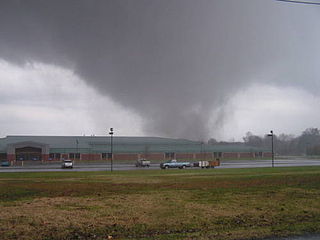
A tornado warning is a public warning that is issued by weather forecasting agencies to an area in the direct path of a tornado, or a thunderstorm capable of producing one, and advises individuals in that area to take cover. Modern weather surveillance technology such as Doppler weather radar can detect rotation in a thunderstorm, allowing for early warning before a tornado develops. They are also commonly issued based on reported visual sighting of a tornado, funnel cloud, or wall cloud, typically from weather spotters or the public, but also law enforcement or local emergency management. When radar is unavailable or insufficient, such ground truth is crucial. In particular, a tornado can develop in a gap of radar coverage, of which there are several known in the United States.

<span class="mw-page-title-main">Tornado watch</span> Weather watch indicating conditions favorable for tornado development in severe thunderstorms

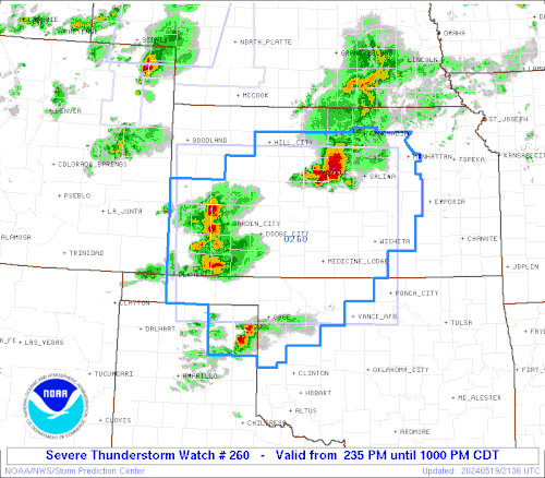
A tornado watch is a severe weather watch product of the National Weather Service that is issued by national weather forecasting agencies when meteorological conditions are favorable for the development of severe thunderstorms capable of producing tornadoes. In addition to the potential for tornado development, thunderstorms that develop within the watch area may contain large hail, straight-line winds, intense rainfall and/or flooding that pose a similar damage risk as the attendant tornado threat. A tornado watch does not mean a tornado is active or will appear, just that favorable conditions increases the likelihood of such happening. A watch must not be confused with a tornado warning.

<span class="mw-page-title-main">Severe thunderstorm warning</span> Weather warning indicating an observed severe thunderstorm

A severe thunderstorm warning is a type of public warning for severe weather that is issued by weather forecasting agencies worldwide when one or more severe thunderstorms have been detected by Doppler weather radar, observed by weather spotters, or reported by an emergency management agency, law enforcement, or the general public. Unlike a watch, a warning is issued to areas in the direct path of active severe thunderstorms, that are expecting a direct impact typically within an hour. Severe thunderstorms can cause property damage and injury due to large hail, high winds, and flooding due to torrential rainfall. The exact criteria to issue a warning varies from country to country.

<span class="mw-page-title-main">National Weather Service</span> U.S. forecasting agency of the National Oceanic and Atmospheric Administration

The National Weather Service (NWS) is an agency of the United States federal government that is tasked with providing weather forecasts, warnings of hazardous weather, and other weather-related products to organizations and the public for the purposes of protection, safety, and general information. It is a part of the National Oceanic and Atmospheric Administration (NOAA) branch of the Department of Commerce, and is headquartered in Silver Spring, Maryland, within the Washington metropolitan area. The agency was known as the United States Weather Bureau from 1890 until it adopted its current name in 1970.

<span class="mw-page-title-main">Storm Prediction Center</span> American severe weather forecasting center

The Storm Prediction Center (SPC) is a US government agency that is part of the National Centers for Environmental Prediction (NCEP), operating under the control of the National Weather Service (NWS), which in turn is part of the National Oceanic and Atmospheric Administration (NOAA) of the United States Department of Commerce (DoC).

The National Severe Storms Laboratory (NSSL) is a National Oceanic and Atmospheric Administration (NOAA) weather research laboratory under the Office of Oceanic and Atmospheric Research. It is one of seven NOAA Research Laboratories (RLs).

This article describes severe weather terminology used by the National Weather Service (NWS) in the United States. The NWS, a government agency operating as an arm of the National Oceanic and Atmospheric Administration (NOAA) branch. It defines precise meanings for nearly all of its weather terms.

<span class="mw-page-title-main">Tornado outbreak of November 15, 2005</span> Tornado outbreak in US

A destructive tornado outbreak impacted the Midwestern United States and Tennessee River Valley on November 15, 2005. It occurred along a cold front separating warm, humid air from the southeast from cold Arctic air to the north and northwest. 49 tornadoes were confirmed in the central United States in the states of Alabama, Arkansas, Illinois, Indiana, Kentucky, Missouri and Tennessee over that afternoon and evening. Strong winds and large hail caused additional damage throughout the region.

<span class="mw-page-title-main">Tornado outbreak of January 2, 2006</span>

The tornado outbreak of January 1–2, 2006, was one of the largest tornado outbreaks ever recorded in the month of January. The outbreak affected much of the Central and Southern United States and produced 20 tornadoes. The tornadoes caused considerable damage in the states of Kentucky and Georgia. There were no tornado related fatalities and only minor injuries were reported.

In weather forecasting in the United States, "particularly dangerous situation" (PDS) is enhanced wording used by the National Weather Service to convey special urgency in some watch or warning messages for unusually extreme and life-threatening severe weather events, above and beyond the average severity for the type of event. It is used in the format "This is a particularly dangerous situation..." at the discretion of the issuing forecaster. A watch or warning bearing the phrase is referred to as a PDS watch or PDS warning as shorthand jargon.

A significant weather advisory was a hazardous weather statement issued by certain Weather Forecast Offices (WFO) of the National Weather Service (NWS) in the United States to alert the public of thunderstorm activity that is below designated severe criteria for and/or is not expected to produce severe weather. The title assigned to the advisory — alternately titled "significant weather alert" or referenced by its originating product, "special weather statement" — varied by the issuing WFO.

Convective storm detection is the meteorological observation, and short-term prediction, of deep moist convection (DMC). DMC describes atmospheric conditions producing single or clusters of large vertical extension clouds ranging from cumulus congestus to cumulonimbus, the latter producing thunderstorms associated with lightning and thunder. Those two types of clouds can produce severe weather at the surface and aloft.

A Special Weather Statement is a form of weather advisory. Special Weather Statements are issued by the National Weather Service of the United States (NWS) and the Meteorological Service of Canada (MSC). There are no set criteria for special weather statements in either country.

<span class="mw-page-title-main">Tornado outbreak sequence of May 2003</span>

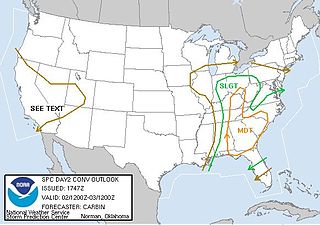
From May 3 to May 11, 2003, a prolonged and destructive series of tornado outbreaks affected much of the Great Plains and Eastern United States. Most of the severe activity was concentrated between May 4 and May 10, which saw more tornadoes than any other week-long span in recorded history; 335 tornadoes occurred during this period, concentrated in the Ozarks and central Mississippi River Valley. Additional tornadoes were produced by the same storm systems from May 3 to May 11, producing 363 tornadoes overall, of which 62 were significant. Six of the tornadoes were rated F4, and of these four occurred on May 4, the most prolific day of the tornado outbreak sequence; these were the outbreak's strongest tornadoes. Damage caused by the severe weather and associated flooding amounted to US$4.1 billion, making it the costliest U.S. tornado outbreak of the 2000s. A total of 50 deaths and 713 injuries were caused by the severe weather, with a majority caused by tornadoes; the deadliest tornado was an F4 that struck Madison and Henderson counties in Tennessee, killing 11. In 2023, tornado expert Thomas P. Grazulis created the outbreak intensity score (OIS) as a way to rank various tornado outbreaks. The tornado outbreak sequence of May 2003 received an OIS of 232, making it the fourth worst tornado outbreak in recorded history.

<span class="mw-page-title-main">National Weather Service Norman, Oklahoma</span> Weather Forecast Office of the National Weather Service

National Weather Service - Norman, Oklahoma is a Weather Forecast Office (WFO) of the National Weather Service based in Norman, Oklahoma, which is responsible for forecasts and the dissemination of weather warnings and advisories for central and most of western Oklahoma, and western portions of north Texas. It is located in the National Weather Center on the University of Oklahoma campus, where it acts as one of the NOAA Weather Partners, a group of close-together weather-related agencies of the National Oceanic and Atmospheric Administration. NWS Norman is currently overseen by Mark Fox, who serves as the Meteorologist In Charge of the office.

The following is a glossary of tornado terms. It includes scientific as well as selected informal terminology.

<span class="mw-page-title-main">National Weather Service Kansas City/Pleasant Hill, Missouri</span> NWS Forecast Office serving west central Missouri, east central Kansas

National Weather Service - Pleasant Hill/Kansas City, Missouri is a Weather Forecast Office (WFO) of the National Weather Service, which is responsible for forecasts and the dissemination of weather warnings and advisories for 37 counties in northern and western Missouri and seven counties in extreme eastern Kansas, including the Kansas City and St. Joseph metropolitan areas. Though, as the Storm Prediction Center (SPC) in Norman, Oklahoma is responsible for issuing severe thunderstorm and tornado watches, the Pleasant Hill/Kansas City WFO only composes outline and status updates for SPC-issued watches affecting any portion of its designated County Warning Area.

<span class="mw-page-title-main">Tornado outbreak of November 29–30, 2022</span> Late-season tornado outbreak in the Southern United States

A late-season tornado outbreak in the Southern United States affected the states of Louisiana, Mississippi, Alabama, and Georgia, from the afternoon of November 29 into the morning of November 30, 2022. The outbreak was the result of an intense upper-level trough that materialized over the aforementioned states where increased moisture, atmospheric instability, and elevated wind shear were present, creating conditions highly conducive to supercell thunderstorms. Multiple tornadic storms developed in the risk area, producing numerous tornadoes. Several of these tornadoes were strong and destructive, prompting the issuance of multiple PDS tornado warnings. Two low-end EF3 tornadoes caused severe damage near Clarks, Louisiana and Tibbie, Alabama respectively while the Flatwood and Willow Springs communities north of Montgomery, Alabama was struck by an EF2 tornado, which caused two fatalities. Numerous weaker tornadoes also touched down, including a high-end EF1 tornado that caused considerable damage in Eutaw, Alabama. In all, 27 tornadoes were confirmed.

<span class="mw-page-title-main">John E. Hales Jr.</span> American meteorologist (born 1942)

John E. "Jack" Hales Jr. is a retired American meteorologist specializing in severe convective storms and tornadoes.

<span class="mw-page-title-main">Tornado outbreak and derecho of April 1–3, 2024</span> Tornado outbreak that impacted the US

From April 1 to 3, 2024, a significant tornado outbreak, which also included a derecho, affected much of the Midwestern and Southeastern United States. The National Weather Service issued dozens of severe thunderstorm and tornado warnings across West Virginia, Kentucky, Tennessee, Ohio, Oklahoma, Kansas Illinois, Indiana, and Missouri during the event. A total of 32 million people were estimated to be under watches or warnings, and over 150,000 people were estimated to be without power. and 15 people were injured. The event was given an outbreak intensity score of 28 points, ranking it as a significant tornado outbreak, and five people were killed by non-tornadic events as well.

References

  1. "Severe Weather Definitions". weather.gov. Retrieved October 23, 2019.
  2. "Severe Weather Facts". factsjustforkids.com. Retrieved October 23, 2019.
  3. Howerton, Paul (2008-06-12). "Severe Thunderstorm Warning". Iowa Environmental Mesonet NWS Product Archive. Retrieved 2010-01-10.
  4. 1 2 3 "Severe Thunderstorm Watch". NOAA National Weather Service Glossary. Retrieved March 18, 2021.
  5. National Weather Service Twin Cities, MN (April 22, 2010). "Severe Weather Awareness Week". National Oceanic and Atmospheric Administration. Archived from the original on April 26, 2010. Retrieved December 15, 2010.
  6. "3.2.1.1 Geographical responsibilities" (PDF). ofcm.gov. Archived from the original (PDF) on 9 August 2003. Retrieved 3 January 2013.
  7. 1 2 3 4 5 6 7 "SPC Products". Storm Prediction Center. Retrieved March 16, 2021.
  8. 1 2 Roger Edwards; Gregory W. Carbin; Stephen F. Corfidi. "OVERVIEW OF THE STORM PREDICTION CENTER" (PDF). Storm Prediction Center . Retrieved March 8, 2021.
  9. 1 2 "NATIONAL WEATHER SERVICE INSTRUCTION 10-511: WFO SEVERE WEATHER PRODUCTS SPECIFICATION" (PDF). National Weather Service Analyze, Forecast, and Support Office. National Oceanic and Atmospheric Administration. April 15, 2020. Retrieved March 7, 2021.
  10. 1 2 3 4 "NATIONAL WEATHER SERVICE INSTRUCTION 10-512: NATIONAL SEVERE WEATHER PRODUCTS SPECIFICATION" (PDF). National Weather Service Analyze, Forecast, and Support Office. National Oceanic and Atmospheric Administration. October 9, 2017. Retrieved March 16, 2021.
  11. "Severe Thunderstorm Watch". ec.gc. 25 February 2013. Retrieved 22 January 2014.
  12. "Severe Thunderstorm". ec.gc. 9 December 2013. Retrieved 22 January 2014.
  13. "Criteria for public weather alerts". Environment and Climate Change Canada. Retrieved March 16, 2021.
  14. 1 2 "Weather Icons". Philippine Atmospheric, Geophysical and Astronomical Services Administration. Retrieved March 17, 2021.
  15. "Thunderstorm advisory". Balitanghali . GMA News and Public Affairs. May 20, 2019. GMA News TV. Archived from the original on 2021-12-12. Retrieved March 17, 2021 via YouTube.