Sheridan, West Virginia

Last updated

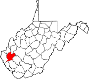
Sheridan is an unincorporated community in Lincoln County, in the U.S. state of West Virginia. [1]

Lincoln County, West Virginia county in West Virginia, United States

Lincoln County is a county in the U.S. state of West Virginia. As of the 2010 census, the population was 21,720. Its county seat is Hamlin. The county was created in 1867 and named for Abraham Lincoln.

U.S. state constituent political entity sharing sovereignty as the United States of America

In the United States, a state is a constituent political entity, of which there are currently 50. Bound together in a political union, each state holds governmental jurisdiction over a separate and defined geographic territory and shares its sovereignty with the federal government. Due to this shared sovereignty, Americans are citizens both of the federal republic and of the state in which they reside. State citizenship and residency are flexible, and no government approval is required to move between states, except for persons restricted by certain types of court orders. Four states use the term commonwealth rather than state in their full official names.

West Virginia State of the United States of America

West Virginia is a state located in the Appalachian region in the Southern United States and is also considered to be a part of the Middle Atlantic States. It is bordered by Pennsylvania to the north, Maryland to the east and northeast, Virginia to the southeast, Kentucky to the southwest, and Ohio to the northwest. West Virginia is the 41st largest state by area, and is ranked 38th in population. The capital and largest city is Charleston.

History

A post office called Sheridan was established in 1887, and remained in operation until 1947. [2] The community was named after Philip Sheridan, a Union general in the American Civil War. [3]

Philip Sheridan United States Army general

Philip Henry Sheridan was a career United States Army officer and a Union general in the American Civil War. His career was noted for his rapid rise to major general and his close association with General-in-chief Ulysses S. Grant, who transferred Sheridan from command of an infantry division in the Western Theater to lead the Cavalry Corps of the Army of the Potomac in the East. In 1864, he defeated Confederate forces under General Jubal Early in the Shenandoah Valley and his destruction of the economic infrastructure of the Valley, called "The Burning" by residents, was one of the first uses of scorched earth tactics in the war. In 1865, his cavalry pursued Gen. Robert E. Lee and was instrumental in forcing his surrender at Appomattox.

Related Research Articles

Intercourse, Alabama Unincorporated community in Alabama, United States

Intercourse, is an unincorporated community located at a crossroads in Sumter County, Alabama, United States.

Gallipolis Ferry, West Virginia Census-designated place in West Virginia, United States

Gallipolis Ferry is a census-designated place (CDP) in Mason County, West Virginia, USA. It is situated on the Ohio River along West Virginia Route 2. As of the 2010 census, its population was 817. It is the site of the Robert C. Byrd Locks & Dam on the Ohio. The community was named for the fact a ferry once provided service between the town site and nearby Gallipolis, Ohio.

Huggins, Missouri Unincorporated community in Missouri, USA

Huggins is an unincorporated community in western Texas County, Missouri, United States, about thirteen miles west of Houston. It is located on Route M about two miles north of Route 38 near Bendavis.

Wakatomika, Ohio human settlement in United States of America

Wakatomika is an unincorporated community in central Washington Township, Coshocton County, Ohio, United States. Wakatomika is located on the Little Wakatomika Creek, and lies along State Route 60.

Ninaview, Colorado Unincorporated community in Colorado, United States

Ninaview is an unincorporated community in Bent County, Colorado, United States. The U.S. Post Office at Las Animas now serves Ninaview postal addresses.

Laurel Grove is an unincorporated community in Westmoreland County, in the U. S. state of Virginia.

Lahore is a town in Orange County, Virginia in the United States of America, which was named after the historical city of Lahore in Punjab, modern day Pakistan in the 1850s. The latitude of Lahore is 38.198N. The longitude is -77.969W. It is in the Eastern Standard time zone. The elevation is 364 feet (111 m).

Gills is an unincorporated community located in Amelia County, in the U.S. state of Virginia.

Cunningham is an unincorporated community in Chariton County, in the U.S. state of Missouri.

Beale is an unincorporated community in Mason County, in the U.S. state of West Virginia.

Blue Spring is an unincorporated community in Randolph County, in the U.S. state of West Virginia.

Bradyville is an unincorporated community in Lincoln County, in the U.S. state of West Virginia.

Hager is an unincorporated community in Lincoln County, in the U.S. state of West Virginia.

Hubball is an unincorporated community in Lincoln County, in the U.S. state of West Virginia.

Maggie is an unincorporated community in Mason County, in the U.S. state of West Virginia.

Portersville is an unincorporated community in Lincoln County, in the U.S. state of West Virginia.

Walgrove is an unincorporated community in Kanawha County, in the U.S. state of West Virginia.

Wellford is an unincorporated community in Kanawha County, in the U.S. state of West Virginia.

Yantus is an extinct town in Logan County, in the U.S. state of West Virginia.

Grays Point is an extinct town in Scott County, in the U.S. state of Missouri.

References

Coordinates: 38°14′25″N82°11′55″W / 38.24028°N 82.19861°W / 38.24028; -82.19861

Geographic coordinate system Coordinate system

A geographic coordinate system is a coordinate system that enables every location on Earth to be specified by a set of numbers, letters or symbols. The coordinates are often chosen such that one of the numbers represents a vertical position and two or three of the numbers represent a horizontal position; alternatively, a geographic position may be expressed in a combined three-dimensional Cartesian vector. A common choice of coordinates is latitude, longitude and elevation. To specify a location on a plane requires a map projection.