Gill, West Virginia

Last updated
Gill, West Virginia
Log boom at Gill, WV Log Boom at Gill, WV.jpg
Log boom at Gill, WV
Brumfield log boom location, 2016
USA West Virginia location map.svg
Red pog.svg
Gill
Usa edcp location map.svg
Red pog.svg
Gill
Coordinates: 38°5′16″N82°7′16″W / 38.08778°N 82.12111°W / 38.08778; -82.12111 Coordinates: 38°5′16″N82°7′16″W / 38.08778°N 82.12111°W / 38.08778; -82.12111
Country United States
State West Virginia
County Lincoln
Elevation
623 ft (190 m)
Time zone UTC-5 (Eastern (EST))
  Summer (DST) UTC-4 (EDT)
GNIS feature ID1549701 [1]

Gill is an unincorporated community and former railroad town in Lincoln County, West Virginia, United States.

Contents

Geography

Gill is located between the mouth of Little Ugly Creek and Big Ugly Creek on the Guyandotte River in Lincoln County. Land situated across the river was once considered part of Gill. The community is located approximately five miles from Harts and 5.1 miles from Ranger.

History

Captain Farley's Raid

Captain Henry Farley, a veteran of the Revolutionary War and resident of Montgomery County, Virginia, was the first known Anglo visitor to present-day Gill. In June 1792, Captain Farley passed through the area while pursuing a Native American war party that had raided Virginia settlements at Bluestone River. By the time he reached what is today Gill, he and his group had already engaged the retreating natives in the headwaters of Coal River and in the Guyandotte River valley some two miles below what is today Logan. Farley pursued the natives to the mouth of the Guyandotte River before returning home. [2]

Pioneer settlers

John H. Brumfield grave, 2016 John H. Brumfield Grave.jpg
John H. Brumfield grave, 2016

William Wirt Brumfield first settled at the mouth of Big Ugly Creek, arriving about 1802 from the Big Stoney Creek section of what was then Montgomery County, Virginia but is now Giles County, Virginia. A War of 1812 soldier and gentleman justice of the County Court, he left the Ugly Creek section and settled at Buffalo Shoals in present-day Wayne County, West Virginia. His son, John H. Brumfield, populated the mouth of Ugly. Paris Brumfield, a son of John H. and a major character in the Lincoln County Feud, was born and raised in this vicinity. One noteworthy resident was Lewis "Jupiter" Fry, a well-known fiddler. Sampson S. Brumfield operated a log boom near the mouth of Ugly.

Formation of town

Gill Post Office was established on October 8, 1903. Thomas J. Gill, a timberman and store operator, served as the first postmaster. [3] Later postmasters were Bradley W. Gill (son of Thomas) and Arabelle Gill (merchant mother of Brad). Notable residents in the early 1900s included members of the Cyfers family. At one time, the community boasted a hotel, railroad stop, church, school, and post office.

Decline

Gill, WV, 2016 Near the mouth of Big Ugly Creek.jpg
Gill, WV, 2016

Gill's prosperity was linked to its location at the mouth of Big Ugly Creek and its proximity to the Chesapeake and Ohio Railway. The construction of Route 10 on the opposite side of the Guyandotte River in the 1920s caused the demise of Gill.

Economy

The CSX railroad track crosses the mouth of Big Ugly Creek at Gill, WV. Gill, WV 2017.jpg
The CSX railroad track crosses the mouth of Big Ugly Creek at Gill, WV.

Timbering served as the primary industry. Gas is also important in the community's history. In the early 1900s, the Guyan, Big Ugly and Coal River Railway Company constructed a branch line up Big Ugly Creek from Gill.

Notable residents

Related Research Articles

Lincoln County, West Virginia County in West Virginia, United States

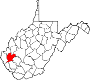
Lincoln County is a county in the U.S. state of West Virginia. As of the 2010 census, the population was 21,720. Its county seat is Hamlin. The county was created in 1867 and named for Abraham Lincoln.

Harts, West Virginia Census-designated place in West Virginia, United States

Harts is a census-designated place (CDP) at the mouth of Big Harts Creek in Lincoln County, West Virginia, United States, situated along the Guyandotte River. As of the 2010 census, its population was 656. Harts is a part of the Huntington-Ashland, WV-KY-OH, Metropolitan Statistical Area (MSA). The Harts CDP includes the unincorporated communities of Harts, Atenville, Ferrellsburg, and Sand Creek.

Chapmanville, West Virginia Town in West Virginia, United States

Chapmanville is a town in Logan County, West Virginia, United States. The population was 1,256 at the 2010 census. Chapmanville, originally called Chapmansville, is named for Ned Chapman, an early settler who operated a store and post office. It was incorporated in 1947.

Guyandotte River

The Guyandotte River is a tributary of the Ohio River, approximately 166 mi (267 km) long, in southwestern West Virginia in the United States. It was named after the French term for the Wendat Native Americans. It drains an area of the unglaciated Allegheny Plateau south of the Ohio between the watersheds of the Kanawha River to the northeast and Twelvepole Creek and the Big Sandy River to the southwest. Via the Ohio River, it is part of the Mississippi River watershed.

Big Ugly Creek is a major tributary of the Guyandotte River in the Harts Creek District of Lincoln County, West Virginia, United States. The naming of this creek was due to 1) an early settler at the mouth of the creek who was unpleasing to the eye; 2) the crooked shape of the creek itself. Big Ugly Creek is a meandering stream stretching nearly 20 miles from U.S. Route 119 northeast of Chapmanville in Boone County to where it meets the Guyandotte River at Gill, an extinct railroad town north of Harts in Lincoln County. Big Ugly Creek is also at the southern end of the state's largest mountaintop removal mine, Arch Coal's Hobet 21. The mine stretches nearly 15 miles from near Julian, north of Madison in Boone County to right above the end of Fawn Hollow, which joins Big Ugly, not far from the Big Ugly Community Center.

The Big Sandy, East Lynn and Guyan Railroad was incorporated on June 16, 1902.

James Edward "Ed" Haley was a blind professional American musician and composer best known for his fiddle playing.

Kellian Whaley

Kellian Van Rensalear Whaley was a nineteenth-century lumberman and congressman from Virginia before the American Civil War and West Virginia after the state's creation. During the Civil War, Whaley was major of the 9th West Virginia Volunteer Infantry and captured during a Confederate raid, but escaped his captors.

Ferrellsburg, West Virginia Unincorporated community in West Virginia, United States

Ferrellsburg is an unincorporated community in southern Lincoln County, West Virginia, United States. It is located in Harts Creek District and is part of the Harts census-designated place.

Peach Creek, West Virginia Census-designated place in West Virginia, United States

Peach Creek is an unincorporated community and census-designated place (CDP) in Logan County, West Virginia, United States. Peach Creek is located on the east bank of the Guyandotte River across from West Logan. Peach Creek has a post office with ZIP code 25639. The community was first listed as a CDP prior to the 2020 census.

Earling, West Virginia Census-designated place in West Virginia, United States

Earling is an unincorporated community and census-designated place (CDP) in Logan County, West Virginia, United States. It was first listed as a CDP prior to the 2020 census. The Earling post office closed on July 1, 1989. The town now shares ZIP Code 25632 with Lyburn and Taplin.

Shively, West Virginia Unincorporated community in West Virginia, United States

Shively is an unincorporated community located on the Smokehouse Fork of Big Harts Creek in Logan County, West Virginia, United States. Shively is accessed by County Route 3. It is situated 7.2 miles from Harts and 9.3 miles from Chapmanville.

Whirlwind, West Virginia Unincorporated community in West Virginia, United States

Whirlwind is an unincorporated community on Big Harts Creek in Logan County, West Virginia, United States.

Halcyon, West Virginia Unincorporated community in West Virginia, United States

Halcyon is an unincorporated community located on the West Fork of Big Harts Creek in Logan and Lincoln counties, West Virginia, United States.

Atenville, West Virginia Unincorporated community in West Virginia, United States

Atenville is an unincorporated community in Lincoln County, West Virginia, United States. It is a residential community located in Harts Creek District and is part of the Harts census-designated place.

Toney, West Virginia Unincorporated community in West Virginia, United States

Toney is an unincorporated community in Lincoln County, West Virginia, United States. Its post office was established in 1904 by Brad Toney, merchant.

Eden Park, West Virginia Unincorporated community in West Virginia, United States

Eden Park is a former coal town situated along the Guyandotte River between Atenville and Harts in Lincoln County, West Virginia, United States. It appears in state business directories as early as 1908.

Lincoln County feud

The Lincoln County feud occurred in the Harts Creek community of Lincoln and Logan counties, West Virginia, between 1878 and 1890.

Big Harts Creek

Big Harts Creek, often shortened to "Harts Creek" or "Big Hart," is a major tributary of the Guyandotte River in Lincoln and Logan counties, West Virginia.

Ábbott Branch may refer to:

References

  1. U.S. Geological Survey Geographic Names Information System: Gill, West Virginia
  2. Ragland, Henry Clay (1896). The History of Logan County, West Virginia. Logan, WV: Logan County Banner. pp. 24–25.
  3. Kenny, Hamill (1945). West Virginia Place Names: Their Origin and Meaning, Including the Nomenclature of the Streams and Mountains. Piedmont, WV: The Place Name Press. p. 267.