State Route 253 is a primary state highway in the U.S. state of Virginia. Known as Port Republic Road, the state highway runs 12.18 miles (19.60 km) from U.S. Route 11 in Harrisonburg east to US 340 near Port Republic. SR 253 is a northwest–southeast highway that connects Harrisonburg with Cross Keys and Port Republic in southeastern Rockingham County. The state highway also provides access to portions of James Madison University on either side of Interstate 81 (I-81). SR 253 is maintained by the Virginia Department of Transportation except for the portion in the independent city of Harrisonburg, which is municipally maintained.

U.S. Route 219 (US 219) is a part of the U.S. Highway System that runs from Rich Creek, Virginia, to West Seneca, New York. In the U.S. state of Maryland, the U.S. Highway runs 48.40 miles (77.89 km) from the West Virginia state line near Redhouse to the Pennsylvania state line near Grantsville. Known as Garrett Highway for much of its length in Maryland, US 219 is the primary north–south route in Garrett County, connecting Interstate 68 (I-68) and Oakland. The highway also provides the main access to the resort area of Deep Creek Lake, which includes Maryland's only ski area, Wisp Ski Resort.

Maryland Route 38 is a state highway in the U.S. state of Maryland. Known as Kitzmiller Road, the state highway runs 5.67 miles (9.12 km) from the West Virginia state line at the North Branch Potomac River in Kitzmiller, where the highway continues south as West Virginia Route 42, north to MD 135 on top of Backbone Mountain. MD 38 connects Kitzmiller with the rest of Garrett County and across the North Branch Potomac River to Blaine and Elk Garden in western Mineral County. The state highway was constructed in the late 1920s and early 1930s. MD 38 originally ran from U.S. Route 219 near Thayerville through Deer Park and Altamont to Kitzmiller. The state highway was truncated at Backbone Mountain when MD 135 was extended west to Oakland in the mid-1950s.
Richard Urquhart Goode was an American geographer and topographer with the United States Geological Survey, Northern Transcontinental Railroad Survey, and the Panama Canal Company.
Ben Lomond is an unincorporated community in Mason County, West Virginia, United States. It is located on the eastern bank of the Ohio River at the junction of West Virginia Route 2 and County Route 56,, some 9.7 miles (15.6 km) south-southwest of Point Pleasant.
Center is an unincorporated community in the Town of Center, Rock County, Wisconsin, United States. Located in section 22 of Township 3 North Range 11 East of the Fourth Principal Meridian, Center has been published on USGS maps since 1891. Bethel Cemetery, the Town of Center town hall and Zion Lutheran Church are located in the community in section 22 at the intersection of Rock County Highway A and Church Road.
Parham Road is a circumferential highway in Henrico County in the U.S. state of Virginia. The highway runs 12.08 miles (19.44 km) from Virginia State Route 150 near Tuckahoe east to U.S. Route 301 and SR 2 in Chamberlayne. Parham Road serves the northwestern suburbs of Richmond, including Tuckahoe, Laurel, and Chamberlayne. The four-lane divided highway intersects all of the major highways that extend northwest and north from the city, including Interstate 64 (I-64) and I-95. Parham Road is county maintained except for the portion that is State Route 73, a connector between US 1 and I-95. The Parham Road name was applied to a small portion of the current route by the early 20th century. SR 73 was constructed in the early 1960s. Most of Parham Road from SR 6 to US 1 was constructed as a new four-lane divided highway by Henrico County in the late 1960s; the existing sections were upgraded at the same time. The highway was extended east to its present terminus in the late 1970s. Parham Road was completed south to its present western terminus in 1990 concurrent with the extension of SR 150 across the James River from the Southside of Richmond to Henrico County.
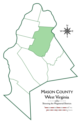
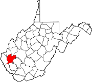
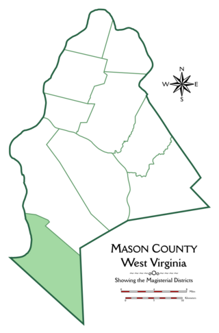
Cooper Magisterial District is one of ten magisterial districts in Mason County, West Virginia, United States. The district was originally established as a civil township in 1863, and converted into a magisterial district in 1872. In 2020, Cooper District was home to 1,700 people.

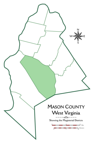
Union Magisterial District is one of ten magisterial districts in Mason County, West Virginia, United States. The district was originally established as a civil township in 1863, and converted into a magisterial district in 1872. In 2020, Union District was home to 1,261 people.
Spilman is an unincorporated community on the Ohio River in Mason County, West Virginia, United States. The village is located along Spilman Lane, Mason County Route 62/24, parallel to West Virginia Route 62 in Waggener District, about three quarters of a mile southeast of West Columbia.
Arbuckle Magisterial District is one of ten magisterial districts in Mason County, West Virginia, United States. The district was originally established as a civil township in 1863, and converted into a magisterial district in 1872. In 2020, Arbuckle District was home to 1,054 people.

Clendenin Magisterial District is one of ten magisterial districts in Mason County, West Virginia, United States. The district was originally established as a civil township in 1863, and converted into a magisterial district in 1872. In 2020, Clendenin District was home to 3,435 people.
Hannan Magisterial District is one of ten magisterial districts in Mason County, West Virginia, United States. The district was originally established as a civil township in 1863, and converted into a magisterial district in 1872. In 2020, Clendenin District was home to 2,688 people.

Grant District, formerly Grant Magisterial District, is one of five historic magisterial districts in Jackson County, West Virginia, United States. The district was originally established as a civil township in 1863, and converted into a magisterial district in 1872. When Jackson County was redistricted in the 1990s, the area of Grant District was included in the new Northern Magisterial District. However, the county's historic magisterial districts continue to exist in the form of tax districts, serving all of their former administrative functions except for the election of county officials.

Ravenswood District, formerly Ravenswood Magisterial District, is one of five historic magisterial districts in Jackson County, West Virginia, United States. The district was originally known as Gilmore Township, one of five civil townships established in 1863; the name officially became "Ravenswood" in 1871, and Jackson County's townships were converted into magisterial districts in 1872. When Jackson County was redistricted in the 1990s, the area of Ravenswood District was divided between the new Northern and Western Magisterial Districts. However, the county's historic magisterial districts continue to exist in the form of tax districts, serving all of their former administrative functions except for the election of county officials.

Ripley District, formerly Ripley Magisterial District, is one of five historic magisterial districts in Jackson County, West Virginia, United States. The district was originally known as Mill Creek Township, one of five civil townships established in Jackson County after West Virginia became a state in 1863; it was renamed "Ripley Township" after its chief town in 1871, and the following year, all of West Virginia's townships were converted into magisterial districts. When Jackson County was redistricted in the 1990s, the area of Ripley District was divided between the new Eastern and Western Magisterial Districts. However, the county's historic magisterial districts continue to exist in the form of tax districts, serving all of their former administrative functions except for the election of county officials.

Washington District, formerly Washington Magisterial District, is one of five historic magisterial districts in Jackson County, West Virginia, United States. The district was originally established as one of five civil townships in Jackson County after West Virginia became a state in 1863; in 1872, all of West Virginia's townships were converted into magisterial districts. When Jackson County was redistricted in the 1990s, Washington District was combined with the eastern portion of Ripley District, including the city of Ripley, to form the new Eastern Magisterial District. However, the county's historic magisterial districts continue to exist in the form of tax districts, serving all of their former administrative functions except for the election of county officials.

The Northern Magisterial District is one of three magisterial districts in Jackson County, West Virginia, United States. It was established during a process of redistricting undertaken in the 1990s. In 2010, 8,753 people lived in the district.

The Eastern Magisterial District is one of three magisterial districts in Jackson County, West Virginia, United States. It was established during a process of redistricting undertaken in the 1990s. In 2010, 9,882 people lived in the district.

The Western Magisterial District is one of three magisterial districts in Jackson County, West Virginia, United States. It was established during a process of redistricting undertaken in the 1990s. In 2010, 10,576 people lived in the district.