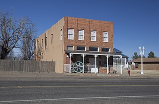
Whiteface is a town in Cochran County, Texas, United States. The population was 449 at the 2010 census.
New Deal is a U.S. town in Lubbock County, Texas. The population was 794 at the 2010 census. It is part of the Lubbock Metropolitan Statistical Area and the Llano Estacado region.

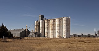
Shallowater is a city in Lubbock County, Texas, United States. Shallowater is on U.S. Route 84 and the Burlington Northern Santa Fe line, 12 miles (19 km) northwest of Lubbock. Its population was 2,484 at the 2010 census. It is part of the Lubbock metropolitan statistical area.

Wilson is a small rural city in the northeastern quadrant of Lynn County, Texas, United States. As of the 2010 census, the population was 489.
Fluvanna is an unincorporated community in Scurry County, Texas, United States. It lies just south of the Llano Estacado, high atop the caprock, where Farm to Market Road 1269 and Farm to Market Road 612 intersect.
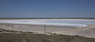
Shafter Lake is a ghost town in Andrews County, Texas, United States, located four miles west of U.S. Route 385 on the shores of a large salt playa named Shafter Lake. It became a ghost town after the town lost an election for county seat of Andrews County.
Acuff is an unincorporated farming community in northeastern Lubbock County, Texas, United States. It is part of the Lubbock Metropolitan Statistical Area.
Woodrow is an unincorporated community in southern Lubbock County, Texas, United States. It lies on U.S. Route 87, ten miles south of Lubbock, and has an estimated population of 85. It is part of the Lubbock Metropolitan Statistical Area.

Southland is an unincorporated community in Garza County, Texas, United States. It lies along the eastern edge of the Llano Estacado on U.S. Route 84, twenty miles northwest of Post.

Cone is an unincorporated community in Crosby County, Texas, United States. It lies on U.S. Route 62, thirty-four miles northeast of Lubbock, has an estimated population of 70, and is the location of the Harmony Plains Singing School.

Kalgary is an unincorporated community in Crosby County, Texas, United States. According to the Handbook of Texas, the community had an estimated population of 70 in 2000.

Fieldton is an unincorporated community in Lamb County, Texas, United States. Fieldton has a post office with the ZIP code 79326.

Bula is an unincorporated community in Bailey County, Texas, United States. According to the Handbook of Texas, the community had a population of 35 in 2000.

Estacado is a ghost town in Crosby and Lubbock Counties in the U.S. state of Texas. Located along Farm to Market Road 1527, it was established in 1879 as a Religious Society of Friends (Quaker) colony by Paris Cox and originally named Maryetta after his wife. In 1886, it became the first government seat of Crosby County. In 1936, Recorded Texas Historic Landmark number 4779 was designated to commemorate the founding of Estacado.

Posey is an unincorporated community located on the level plains of the Llano Estacado, approximately 11 mi (18 km) southeast of Lubbock in southeastern Lubbock County, Texas, United States.
Heckville is an unincorporated community located on the high plains of the Llano Estacado, approximately 16 mi (26 km) northeast of Lubbock or 7 mi (11 km) north of Idalou in northeastern Lubbock County, Texas, United States. This small town was named after Henry Heck, who built a cotton gin to serve the community in 1948.

Becton is an unincorporated community in northeastern Lubbock County, Texas, United States, approximately 18 mi (29 km) northeast of Lubbock. This small rural community lies on the high plains of the Llano Estacado in West Texas.

Needmore is a small unincorporated community in north central Terry County, Texas, United States.

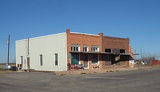
Cuthbert is a ghost town in Mitchell County, Texas, United States. Cuthbert was established in 1890 when the founder D. T. Bozeman built a wagon yard and store. The community and post office were named for Thomas Cuthbertson, a family friend of the Bozemans. By the early 1920s, Cuthbert had a church, two stores, a blacksmith shop, a cotton gin, telephone office, and a school. In 1920, the T. and P. Abrams No. 1 oil well, one of the first commercial oil ventures in the Permian Basin, was drilled just over a mile north of the town. A post office, two businesses, and a population of twenty-five were reported at the community in 1936, the year that its school was consolidated with that of Colorado City. After World War II, the improvement of rural roads in the area led to Cuthbert's decline as it lost its trade to Colorado City. The Cuthbert post office was discontinued circa 1960, when the town reported one business and a population of twenty-five. By 1974, only a cemetery and scattered farms remained in the area.

Whiteflat is a ghost town in Motley County, Texas, United States. The population was estimated to be 3 at the 2000 census.


