Vernon County is a county located in the center of the western border of Missouri. As of the 2010 census, the population was 21,159. Its county seat is Nevada. The county was organized on February 27, 1855, considerably later than counties in the eastern part of the state. It was named for Colonel Miles Vernon (1786–1867), a state senator and veteran of the Battle of New Orleans. This was part of the large historic territory of the Osage Nation of Native Americans.

Shawnee County is a county located in northeast Kansas, in the central United States of America. As of the 2010 census, the population was 177,934 making it the third-most populous county in Kansas. Its most populous city, Topeka, is the state capital and county seat. The county was one of the original 33 counties created by the first territorial legislature in 1855, and it was named for the Shawnee tribe of Native Americans.

Aston Township is a township in Delaware County, Pennsylvania, United States. The population was 16,592 at the 2010 census.
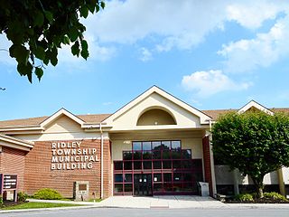
Ridley Township is a township in Delaware County, Pennsylvania, United States. The population was 30,768 at the 2010 census. Ridley Township contains the census designated places of Folsom and Woodlyn along with the unincorporated communities of Crum Lynne and Holmes.
Municipio and município are country subdivisions in Italy and several Hispanophone and Lusophone nations, respectively. They are often translated as "municipality". In the English language, a municipality often is defined as relating to a single city or town; however, in Spanish, the term "municipio" may not mean a single city or town, but rather a jurisdiction housing several towns and cities, like a township, county, borough or civil parish. The Italian term "municipalità" refers either to a single city or a group of cities and towns in a township, but the Portuguese use is almost entirely restricted to group of cities or towns like in a county, township and so forth.

Sheffield Township is one of the twenty-seven townships of Ashtabula County, Ohio, United States. The 2010 census found 1,639 people in the township.

Kirkwood Township is one of the sixteen townships of Belmont County, Ohio, United States. The 2010 census found 400 people in the township.

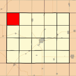
Hittle Township is located in Tazewell County, Illinois. As of the 2010 census, its population was 591 and it contained 254 housing units. Hittle Township was originally called Union Township. The name was changed from Union to Waterford Township on May 20, 1850, and again from Waterford to Armington Township in August, 1850. Armington was changed to Hittle though on November 11 of that same year.
The Township of Manvers was a municipality in the former Victoria County, now the city of Kawartha Lakes, in the Canadian province of Ontario.

Thornton Township is one of twenty-six townships in Buffalo County, Nebraska, United States. The population was 181 at the 2000 census. A 2006 estimate placed the township's population at 178. In 1883 the Buffalo County Board of Directors named the township for Samuel W. Thornton, a local politician, farmer, and Civil War soldier.

Banner Township is a township in Jackson County, Kansas, USA. As of the 2000 census, its population was 300. The southernmost part of the township is located within the Prairie Band Potawatomi Indian Reservation.

Douglas Township is a township in Jackson County, Kansas, USA. As of the 2000 census, its population was 2,135.

Grant Township is a township in Jackson County, Kansas, USA. As of the 2000 census, its population was 212. The southeasternmost part of the township is located within the Prairie Band Potawatomi Indian Reservation.

Jefferson Township is a township in Jackson County, Kansas, USA. As of the 2000 census, its population was 494.

Lincoln Township is a township in Jackson County, Kansas, USA. As of the 2000 census, its population was 1,046. The township is located entirely within the Prairie Band Potawatomi Indian Reservation.

Soldier Township is a township in Jackson County, Kansas, USA. As of the 2000 census, its population was 403.

Rock Creek Township is a township in Jefferson County, Kansas, USA. As of the 2000 census, its population was 2,718.

Duck Island is an unincorporated community located along the border of Hamilton Township and the city of Trenton in Mercer County, New Jersey, United States. The community takes its name from Duck Island, which extends southeastward from the community. The city of Trenton provides public docks for fishing in Duck Island.

The John Abbott II House was built ca. 1730 in what is now Hamilton Township, Mercer County, New Jersey. During the American Revolution, Samuel Tucker, the state treasurer, fleeing the British advance on Trenton, removed the money in his care to the home of John Abbott II. The location of the funds was betrayed by Mrs. Mary Pointing, who led a 500-strong detachment of British troops to the house. In ransacking the home, the soldiers discovered Tucker's trunk with his personal effects and £1500 in unsigned paper money. However, the specie money was hidden by the family in the bottom of tubs in the cellar, covered with broken dishes and household utensils. The tubs escaped close inspection and the money was kept from British hands. The house is currently home to the Hamilton Township Historical Society and is open to the public.

Cheltenham Township is a home rule township bordering North Philadelphia in Montgomery County, Pennsylvania, United States. Cheltenham's population density ranges from over 10,000 per square mile in rowhouses and high-rise apartments along Cheltenham Avenue to historic neighborhoods in Wyncote and Elkins Park. It is the most densely populated township in Montgomery County. The population was 36,793 at the 2010 U.S. Census, making it the third most populous township in Montgomery County and the 27th most populous municipality in Pennsylvania. It was originally part of Philadelphia County, and it became part of Montgomery County upon that county's creation in 1784.