Westside, Iowa

Last updated
Westside, Iowa
Westside, IA.jpg
Crawford County Iowa Incorporated and Unincorporated areas Westside Highlighted.svg
Location of Westside, Iowa
Coordinates: 42°04′33″N95°06′05″W / 42.07583°N 95.10139°W / 42.07583; -95.10139
Country Flag of the United States.svg  United States
State Flag of Iowa.svg  Iowa
County Crawford
Area
[1]
  Total1.47 sq mi (3.81 km2)
  Land1.47 sq mi (3.81 km2)
  Water0.00 sq mi (0.00 km2)
Elevation
[2]
1,345 ft (410 m)
Population
 (2020)
  Total285
  Density193.75/sq mi (74.81/km2)
Time zone UTC-6 (Central (CST))
  Summer (DST) UTC-5 (CDT)
ZIP code
51467
Area code 712
FIPS code 19-84630
GNIS feature ID2397287 [2]

Westside is a city in Crawford County, Iowa, United States. The population was 285 at the time of the 2020 census. [3]

Contents

History

Westside was laid out in 1872. [4] The city name is derived from its presence slightly to the west of the divide between the Mississippi and Missouri river watersheds. [5]

Geography

According to the United States Census Bureau, the city has a total area of 1.47 square miles (3.81 km2), all land. [6]

Demographics

Historical populations
YearPop.±%
1880 446    
1890 448+0.4%
1900 396−11.6%
1910 367−7.3%
1920 405+10.4%
1930 341−15.8%
1940 373+9.4%
1950 393+5.4%
1960 367−6.6%
1970 389+6.0%
1980 387−0.5%
1990 348−10.1%
2000 327−6.0%
2010 299−8.6%
2020 285−4.7%
Source: "U.S. Census website". United States Census Bureau . Retrieved 2020-03-29. and Iowa Data Center
Source:
U.S. Decennial Census [7] [3]

2010 census

As of the census [8] of 2010, there were 299 people, 143 households, and 91 families living in the city. The population density was 203.4 inhabitants per square mile (78.5/km2). There were 150 housing units at an average density of 102.0 per square mile (39.4/km2). The racial makeup of the city was 99.3% White, 0.3% from other races, and 0.3% from two or more races. Hispanic or Latino of any race were 2.3% of the population.

There were 143 households, of which 21.0% had children under the age of 18 living with them, 55.9% were married couples living together, 4.2% had a female householder with no husband present, 3.5% had a male householder with no wife present, and 36.4% were non-families. 33.6% of all households were made up of individuals, and 19.6% had someone living alone who was 65 years of age or older. The average household size was 2.09 and the average family size was 2.60.

The median age in the city was 52.3 years. 17.4% of residents were under the age of 18; 5.6% were between the ages of 18 and 24; 16.8% were from 25 to 44; 29.8% were from 45 to 64; and 30.4% were 65 years of age or older. The gender makeup of the city was 48.5% male and 51.5% female.

2000 census

As of the census [9] of 2000, there were 327 people, 146 households, and 109 families living in the city. The population density was 220.8 inhabitants per square mile (85.3/km2). There were 154 housing units at an average density of 104.0 per square mile (40.2/km2). The racial makeup of the city was 100.00% White.

There were 146 households, out of which 24.0% had children under the age of 18 living with them, 68.5% were married couples living together, 2.1% had a female householder with no husband present, and 25.3% were non-families. 23.3% of all households were made up of individuals, and 12.3% had someone living alone who was 65 years of age or older. The average household size was 2.24 and the average family size was 2.60.

19.9% are under the age of 18, 4.0% from 18 to 24, 22.0% from 25 to 44, 28.7% from 45 to 64, and 25.4% who were 65 years of age or older. The median age was 47 years. For every 100 females, there were 90.1 males. For every 100 females age 18 and over, there were 98.5 males.

The median income for a household in the city was $37,250, and the median income for a family was $40,357. Males had a median income of $32,500 versus $18,125 for females. The per capita income for the city was $31,545. About 2.5% of families and 3.1% of the population were below the poverty line, including none of those under the age of eighteen or sixty-five or over.

Education

The Ar-We-Va Community School District operates local area schools. [10]

Related Research Articles

<span class="mw-page-title-main">Bridgewater, Iowa</span> City in Iowa, United States

Bridgewater is a city in Jackson Township, Adair County, Iowa, United States. The population was 148 at the time of the 2020 census. Bridgewater was founded in 1885.

<span class="mw-page-title-main">Plano, Iowa</span> City in Iowa, United States

Plano is a city in Appanoose County, Iowa, United States. The population was 59 at the time of the 2020 census.

<span class="mw-page-title-main">Beaver, Iowa</span> City in Iowa, United States

Beaver is a city in Amaqua Township, Boone County, Iowa, United States. The population was 46 at the 2020 census. It is part of the 'Boone, Iowa Micropolitan Statistical Area', which is a part of the larger Ames-Boone, Iowa Combined Statistical Area.

<span class="mw-page-title-main">Newell, Iowa</span> City in Iowa, United States

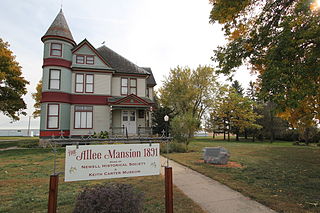
Newell is a city in Buena Vista County, Iowa, United States. The population was 906 according to the 2020 census.

<span class="mw-page-title-main">Royal, Iowa</span> City in Iowa, United States

Royal is a city in Clay County, Iowa, United States. The population was 379 in the 2020 census, a decline from 479 in 2000.

<span class="mw-page-title-main">Strawberry Point, Iowa</span> City in Iowa, United States

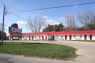
Strawberry Point is a city in Clayton County, Iowa, United States. The population was 1,155 at the time of the 2020 United States Census, down from 1,386 in 2000 census. Strawberry Point is home to the world's largest strawberry, and the Franklin Hotel, which was listed on the National Register of Historic Places in 1999. Backbone State Park, Iowa's oldest state park, is located a few miles from the town.

<span class="mw-page-title-main">Volga, Iowa</span> City in Iowa, United States

Volga is a city in Clayton County, Iowa, United States. The population was 203 at the time of the 2020 census, down from 247 in 2000.

<span class="mw-page-title-main">Charlotte, Iowa</span> City in Iowa, United States

Charlotte is a city in Clinton County, Iowa, United States. The population was 389 at the 2020 census.

<span class="mw-page-title-main">Low Moor, Iowa</span> City in Iowa, United States

Low Moor is a city in Clinton County, Iowa, United States. The population was 250 at the time of the 2020 census.

<span class="mw-page-title-main">Little Sioux, Iowa</span> City in Iowa, United States

Little Sioux is a city in Harrison County, Iowa, United States. The population was 166 at the time of the 2020 census. The city is most known for Little Sioux Scout Ranch of the Boy Scouts of America.

<span class="mw-page-title-main">Packwood, Iowa</span> City in Iowa, United States

Packwood is a city in Jefferson County, Iowa, United States. The population was 183 at the time of the 2020 census. The Burlington and Western Railway arrived in Packwood in late 1882. This was a narrow gauge line, widened to standard gauge in 1902 and taken over by the Chicago, Burlington and Quincy, and then sold to the Minneapolis and St. Louis in 1934.

<span class="mw-page-title-main">Tiffin, Iowa</span> City in Iowa, United States

Tiffin is a city in Johnson County, Iowa, United States. It is part of the Iowa City, Iowa Metropolitan Statistical Area. The population was 4,512 at the time of the 2020 census. F. W. Kent County Park is located just to the west of Tiffin, and is a popular site for outdoor recreation in Johnson County, being noted for its lake, camping facilities, resident whitetail deer herd and wild turkeys, and its cross-country ski trails through rolling acres of oak and hickory forest.

<span class="mw-page-title-main">Walker, Iowa</span> City in Iowa, United States

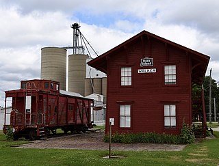
Walker is a city in Linn County, Iowa. The population was 688 at the 2020 census. It is part of the Cedar Rapids, Iowa metropolitan area.

<span class="mw-page-title-main">Lester, Iowa</span> City in Iowa, United States

Lester is a city in Lyon County, Iowa, United States. The population was 296 at the time of the 2020 census.

<span class="mw-page-title-main">State Center, Iowa</span> City in Iowa, United States

State Center is a city in Marshall County, Iowa, United States. The population was 1,391 at the time of the 2020 census. State Center is known as the Rose Capital of Iowa.

<span class="mw-page-title-main">Macedonia, Iowa</span> City in Iowa, United States

Macedonia is a city in Pottawattamie County, Iowa, United States. The population was 267 at the time of the 2020 census.

<span class="mw-page-title-main">Kellerton, Iowa</span> City in Iowa, United States

Kellerton is a city in eastern Ringgold County, Iowa, United States. The population was 243 at the time of the 2020 census.

<span class="mw-page-title-main">McCausland, Iowa</span> City in Iowa, United States

McCausland is a city in Butler Township, Scott County, Iowa, United States. The population was 313 at the time of the 2020 census.

<span class="mw-page-title-main">Huxley, Iowa</span> City in Iowa, United States

Huxley is a city in Story County, Iowa, United States. The population was 4,244 at the time of the 2020 census. It is part of the Ames, Iowa Metropolitan Statistical Area, which is a part of the larger Ames-Boone, Iowa Combined Statistical Area.

<span class="mw-page-title-main">North English, Iowa</span> City in Iowa, United States

North English is a city located mainly in Iowa county with a small portion in Keokuk county in the U.S. state of Iowa. The population was 1,065 at the time of the 2020 census. It is named for the English River.

References

  1. "2020 U.S. Gazetteer Files". United States Census Bureau. Retrieved March 16, 2022.
  2. 1 2 U.S. Geological Survey Geographic Names Information System: Westside, Iowa
  3. 1 2 "2020 Census State Redistricting Data". census.gov. United states Census Bureau. Retrieved 12 August 2021.
  4. History of Western Iowa, Its Settlement and Growth. Western Publishing Company. 1882. pp.  481.
  5. Chicago and North Western Railway Company (1908). A History of the Origin of the Place Names Connected with the Chicago & North Western and Chicago, St. Paul, Minneapolis & Omaha Railways. p. 138.
  6. "US Gazetteer files 2010". United States Census Bureau . Retrieved 2012-05-11.
  7. "Census of Population and Housing". Census.gov. Retrieved June 4, 2015.
  8. "U.S. Census website". United States Census Bureau . Retrieved 2012-05-11.
  9. "U.S. Census website". United States Census Bureau . Retrieved 2008-01-31.
  10. "FY20_AR-WE-VA" (PDF). Iowa Department of Education. Retrieved 2020-08-03.