Spruce River (Saskatchewan)

Last updated

Spruce River
Little Red River
North Saskatchewan basin map.png
North Saskatchewan River drainage basin
Canada Saskatchewan relief location map.jpg
Red pog.svg
Location of the mouth in Saskatchewan
Canada relief map 2.svg
Red pog.svg
Spruce River (Saskatchewan) (Canada)
Location
CountryFlag of Canada (Pantone).svg  Canada
Provinces
Physical characteristics
Source Waskesiu Hills
  location Prince Albert National Park
  coordinates 53°47′23″N106°23′42″W / 53.7896°N 106.3951°W / 53.7896; -106.3951
Mouth North Saskatchewan River
  location
Prince Albert
  coordinates
53°13′06″N105°42′45″W / 53.2184°N 105.7125°W / 53.2184; -105.7125
  elevation
415 m (1,362 ft)
Basin size1,668 km2 (644 sq mi)
Basin features
Tributaries 
  left
  • Christopher Creek
  right
  • McKenzie Creek
  • Bell Creek

Spruce River, [1] also called Little Red River, is a river in the north-central region of the Canadian province of Saskatchewan. It begins in the Waskesiu Hills [2] in Prince Albert National Park and flows generally in a southward direction through boreal forests, glacier-carved hills and valleys, [3] muskeg, and prairie en route to the North Saskatchewan River at the east end of the city of Prince Albert.

Contents

Several lakes with recreational amenities such as Namekus, McPhee, Anglin, Emma, Christopher, and Halkett are within its watershed. Anglin Lake was created by the building of Spruce River Dam along the river's course.

Course and description

Spruce River begins at an unnamed lake at an elevation of over 710 metres (2,330 ft) in the Nimrod Hills range [4] of the Waskesiu Hills, just south of the source for the neighbouring Sturgeon River [5] in Prince Albert National Park. Sturgeon River parallels Spruce River south to the North Saskatchewan River ending up on the western side of Prince Albert. From its source, the Spruce River heads south out of the Nimrod Hills dropping over 60 metres (200 ft) in elevation into a valley. From there, it follows the valley east towards a natural portage at Beartrap Lake and Beartrap Creek. Beartrap Creek [6] flows north into Waskesiu Lake and is part of the Churchill River watershed. From the portage, Spruce River turns south following a valley towards Anglin Lake and Spruce River Dam at the eastern boundary of Prince Albert National Park and the western boundary of Great Blue Heron Provincial Park. South of the dam, Spruce River leaves Prince Albert National Park and passes through three Indian reserves (Little Red River 106D, Montreal Lake 106B, and Little Red River 106C) before entering the RM of Buckland No. 491. From the Little Red River Indian Reserves south, Spruce River is also known as Little Red River. Once in the RM, the river carries on southward passing through Wahpaton Indian Reserve and Little Red River Park [7] before entering the east end of Prince Albert and emptying into the North Saskatchewan River near Bateman Island. [8]

Tributaries

The following are the tributaries of Spruce River from its headwaters in the Waskesiu Hills to its mouth at the North Saskatchewan River:

Spruce River Dam

The Spruce River Dam ( 53°39′59″N106°00′31″W / 53.6663°N 106.0085°W / 53.6663; -106.0085 ), [13] located along the south-eastern boundary of Prince Albert National Park, was built in 1960 along the course of the Spruce River by the Government of Canada's Department of Northern Affairs to regulate flow along the river and to provide additional water for a diversion into the recreational lakes of Emma and Christopher. About 2.5 km (1.6 mi) upstream was another dam that was built in 1939. The 1960 Spruce River Dam was built to replace that 1939 dam as it was prone to washouts. The building of the Spruce River Dam also over-flowed the Tower Road Dams that were used to control the water levels of Anglin Lake's Jacobsen Bay by .4 m (1 ft 4 in). With the building of the dam, Anglin Lake water levels increased from the original levels by 1 m (3 ft 3 in).

Spruce River Dam is 243 m (797 ft) long and 6.1 m (20 ft) high. It is an embankment dam with a concrete spillway made up of four 2.43 m (8 ft 0 in) wide stop-log bays. A grated culvert controls the water's flow between 1 April and 31 October to allow a riparian downstream flow of .14 m3 (4.9 cu ft)/second. [14] Access to the dam is from Highway 953.

Emma Lake diversion

The Emma Lake diversion project was built in conjunction with Spruce River Dam. About one kilometre north-east of the dam along Anglin Lake's eastern shore is a pumphouse that lifts water up eight metres at a maximum rate of .65 m3 (23 cu ft) through a 284 m (932 ft) long pipeline into a 10-kilometre long diversion channel that flows into Emma Lake at its northern end. The diversion channel went into operation 1961 and, within a few years, Emma Lake water levels rose 1.8 m (5 ft 11 in) above 1960 levels. At the south-eastern corner of Emma Lake, a short channel was built connecting Emma to Christopher Lake. This channel, called the Christopher Lake diversion, opened in 1965 and, within a few years, had risen the water levels of Christopher Lake by 2.2 m (7 ft 3 in) above 1960 levels. At the southern end of Christopher Lake, a partially man-made, partially natural channel called Christopher Creek [15] was constructed that connects with Spruce River farther downstream, south of Little Red River Indian Reserve. Prior to the construction of the Emma Lake diversion, Emma and Christopher Lakes did not connect to Spruce River. [16]

Parks and recreation

The Spruce River begins in the south-central area of Prince Albert National Park in the Waskesiu Hills. From there it heads east then south near the south-eastern boundary of the park. The park has multiple trails throughout and several of them run along or intersect with the Spruce River. The Spruce River Trail [17] and the Freight Tait Springs Trail [18] both follow sections of the river and the trailhead for Spruce River Highlands Trail is on Highway 263 at the river crossing. The Spruce River Highlands Trail has a one-kilometre spur trail [19] that connects up with 18 kilometres of trails in neighbouring Great Blue Heron Provincial Park by Anglin Lake. [20] Most of Anglin Lake is in Great Blue Heron Provincial Park and there are several campgrounds, hiking trails, and fishing opportunities at the lake. [21]

Little Red River Park

Little Red River Park is a Prince Albert city park located near the mouth of the Spruce River. It is a 500 ha (1,200 acres) forested park that provides year-round recreational opportunities. There are over 30 km (19 mi) of trails for hiking, cycling, cross-country skiing, and snowshoeing. [22]

Fish species

Fish commonly found in the river include walleye and northern pike. [23]

See also

Related Research Articles

<span class="mw-page-title-main">South Saskatchewan River</span> River in Western Canada

The South Saskatchewan River is a major river in the Canadian provinces of Alberta and Saskatchewan. The river begins at the confluence of the Bow and Oldman Rivers in southern Alberta and ends at the Saskatchewan River Forks in central Saskatchewan. The Saskatchewan River Forks is the confluence of the South and North Saskatchewan Rivers and is the beginning of the Saskatchewan River.

<span class="mw-page-title-main">Prince Albert National Park</span> National park in Saskatchewan, Canada

Prince Albert National Park encompasses 3,874 square kilometres (1,496 sq mi) in central Saskatchewan, Canada and is about 200 kilometres (120 mi) north of Saskatoon. Though declared a national park March 24, 1927, official opening ceremonies weren't performed by Prime Minister William Lyon Mackenzie King until August 10, 1928. This park is open all year but the most visited period is from May to September. Although named for the city of Prince Albert, the park's main entrance is actually 80 kilometres (50 mi) north of that city via Highways 2 and 263, which enters the park at its southeast corner. Two additional secondary highways enter the park, Highway 264, which branches off Highway 2 just east of the Waskesiu townsite, and Highway 240, which enters the park from the south and links with 263 just outside the entry fee-collection gates. Prince Albert National Park is not located within any rural municipality, and is politically separate from the adjacent Northern Saskatchewan Administration District (NSAD). Until the establishment of Grasslands National Park in 1981, it was the province's only national park.

<span class="mw-page-title-main">Emma Lake (Saskatchewan)</span> Lake in Saskatchewan, Canada

Emma Lake is a recreational lake in the Canadian province of Saskatchewan. It is located near the southern limit of the boreal forest, about 45 kilometres (28 mi) north of Prince Albert. The lake is within the District of Lakeland No. 521 and east of Prince Albert National Park. There are several small communities and recreational opportunities around Emma Lake and much of the northern half is within Great Blue Heron Provincial Park. Access to the lakes is from Highways 953, 952, and 263.

<span class="mw-page-title-main">North Saskatchewan River</span> River in Western Canada

The North Saskatchewan River is a glacier-fed river that flows from the Canadian Rockies continental divide east to central Saskatchewan, where it joins with the South Saskatchewan River to make up the Saskatchewan River. Its water flows eventually into the Hudson Bay.

Highway 263 is a provincial highway in the Canadian province of Saskatchewan. Saskatchewan's 200-series highways primarily service its recreational areas. The highway runs from Highway 2 to Highway 264 in Prince Albert National Park at Waskesiu Lake. It is about 63 kilometres (39 mi) long.

<span class="mw-page-title-main">Candle Lake (Saskatchewan)</span> Lake in Saskatchewan, Canada

Candle Lake is a reservoir in the central part of the Canadian province of Saskatchewan in the boreal forest, approximately 80 kilometres (50 mi) north-east of Prince Albert. A dam completed in 1979 at the southern end of the lake regulates water levels; several small creeks feed into the lake and Torch River flows out of the lake at the dam. Candle Lake Provincial Park surrounds most of the lake and the resort village of Candle Lake is at the southern end.

Sturgeon Lake is lake in the Canadian province of Saskatchewan. It is a small, narrow body of water situated in the transition zone between the aspen parkland and boreal forest biomes. It is located along the course of Sturgeon River, which has its headwaters in Prince Albert National Park and the Waskesiu Hills. The Sturgeon River is a tributary of the North Saskatchewan River. A small dam at the eastern end of the lake helps regulate water levels.

<span class="mw-page-title-main">Waskesiu Lake</span> Lake in Prince Albert National Park, Saskatchewan, Canada

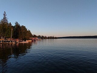
Waskesiu Lake is a lake located roughly in the centre of Prince Albert National Park. The lake's name means red deer or elk in the Cree language. Waskesiu Lake is by far the most developed lake in the park, and features a variety of recreational facilities along all sides of its shoreline, including camping, golfing, boating, and hiking. The resort village of Waskesiu Lake is on its eastern shore. The Prince Albert National Park Nature Centre is located in the village as well as many other amenities such as lodging, police, a gas station, shopping, and restaurants. Access to the lake is from Highways 263 and 264.

Montreal Lake is a lake in the north-central part of Canadian province of Saskatchewan. It is the source of the Montreal River and is located between Highways 2 and 969. Prince Albert National Park is to the west and Clarence-Steepbank Lakes Provincial Park is to the east. Communities on the lake include Montreal Lake, Timber Bay, and Molanosa.

<span class="mw-page-title-main">Sturgeon River (Saskatchewan)</span> River in Saskatchewan, Canada

Sturgeon River is a river in the Hudson Bay drainage basin in the central part of the Canadian province of Saskatchewan. It flows from its source in the Waskesiu Hills in Prince Albert National Park to the North Saskatchewan River, just west of the city of Prince Albert.

<span class="mw-page-title-main">Brightwater Creek</span> River in Saskatchewan, Canada

Brightwater Creek is a river in south central part of the Canadian province of Saskatchewan. It is a tributary of the South Saskatchewan River in a region called the Prairie Pothole Region of North America, which extends throughout three Canadian provinces and five U.S. states. It is also within Palliser's Triangle and the Great Plains ecoregion. Along the river's course there is a dam and reservoir and a regional park. There are no communities along its course.

<span class="mw-page-title-main">Cowan River</span> River in Saskatchewan, Canada

Cowan River is a river in the west-central part of the Canadian province of Saskatchewan in the boreal forest ecozone of Canada. The river begins at Cowan Lake Dam near the northern end of Cowan Lake and flows north-west through muskeg and forest to meet Beaver River. Beaver River then flows into Lac Île-à-la-Crosse and the Churchill River. The entirety of Cowen River is within the Northern Saskatchewan Administration District and while there are no communities along its course, the towns of Big River and Spiritwood are in its watershed.

Great Blue Heron Provincial Park is a recreational park in the central region of the Canadian province of Saskatchewan in the boreal forest ecozone of Canada. It is adjacent to the eastern boundary of Prince Albert National Park, about 50 kilometres (31 mi) north of the city of Prince Albert. The provincial park was established in 2013 from two pre-existing provincial recreation sites – Emma Lake and Anglin Lake Recreation Sites – and the addition of a large tract of Crown land.

Anglin Lake is a reservoir in the boreal forest ecozone in the Canadian province of Saskatchewan. It is east of the Prince Albert National Park in the central part of the province in the District of Lakeland No. 521. Access to the lake is from Highway 953 and it is about 70 kilometres (43 mi) north of the city of Prince Albert. The only community on the lake is Anglin Lake.

<span class="mw-page-title-main">Christopher Lake (Saskatchewan)</span> Lake in Saskatchewan, Canada

Christopher Lake is a recreational lake in the boreal forest ecozone in the Canadian province of Saskatchewan. It is located south-east of Emma Lake and Great Blue Heron Provincial Park in the central part of the province in the District of Lakeland No. 521. Access to Christopher Lake is from Highways 953 and 263 and it is about 42 km (26 mi) north of the city of Prince Albert.

<span class="mw-page-title-main">Waskesiu River</span> River in Saskatchewan, Canada

Waskesiu River is a river that runs through boreal forest in the north-central region of the Canadian province of Saskatchewan. It begins at Waskesiu Lake in Prince Albert National Park and flows north-east to Montreal Lake.

Waskesiu Upland is a hilly plateau in the central region of the Canadian province of Saskatchewan. Waskesiu means red deer or elk in the Cree language. The plateau is just south-west of the geographical centre of the province and consists of two main ranges — the Waskesiu Hills to the south and the Thunder Hills to the north. The Thunder Hills cover an area of about 225,000 acres. Several notable rivers begin from the upland with ones headed south flowing into the North Saskatchewan River and ones headed north flowing into the Churchill River. Much of the plateau is carpeted in boreal forests and most of the Waskesiu Hills range is within Prince Albert National Park. Besides the national park, there are several provincial recreation sites in and around the upland. The northern part of the upland is part of the Northern Saskatchewan Administration District and is sparsely populated.

<span class="mw-page-title-main">Makwa River</span> River in Saskatchewan, Canada

Makwa River is a river in the Canadian province of Saskatchewan in the transition zone between parkland and boreal forest. Makwa is Cree for Loon. The upper reaches of the Makwa River's watershed reach just across the border into Alberta and includes lakes such as Hewett, Ministikwan, Makwa, and Jumbo.

Nesslin Lake is a lake in the Canadian province of Saskatchewan. It is situated at the western end of the Waskesiu Upland in the boreal forest ecozone of Canada. Nesslin Lake is within the Churchill River drainage basin of the Hudson Bay.

Ness Lakes are a group of five interconnected lakes — the largest of which is Ness Lake — in the Canadian province of Saskatchewan. They are in the Rural Municipality of Big River No. 555 at the western end of the Waskesiu Hills in the boreal forest ecozone of Canada. The western boundary of Prince Albert National Park is directly to the east and the town of Big River is about 15 kilometres (9.3 mi) to the south-west. Access to the lakes is from Nesslin Lake Road, which branches off of Highway 922.

References

  1. "Spruce River". Canadian Geographical Names Database. Government of Canada. Retrieved 3 September 2022.
  2. "Waskesiu Hills". Canadian Geographical Names Database. Government of Canada. Retrieved 3 September 2022.
  3. "Waskesiu Upland". The Encyclopedia of Saskatchewan. University of Saskatchewan. Archived from the original on 25 July 2021. Retrieved 3 September 2022.
  4. "Nimrod Hills". Canadian Geographical Names Database. Government of Canada. Retrieved 4 September 2022.
  5. "Sturgeon River". Canadian Geographical Names Database. Government of Canada. Retrieved 3 September 2022.
  6. "Beartrap Creek". Canadian Geographical Names Database. Government of Canada. Retrieved 3 September 2022.
  7. "Little Red River Park". Tourism Saskatchewan. Government of Saskatchewan. Retrieved 3 September 2022.
  8. "Spruce River, Saskatchewan, Canada". mindat. mindat.org and the Hudson Institute of Mineralogy. Retrieved 3 September 2022.
  9. "Cowan Creek". Canadian Geographical Names Database. Government of Canada. Retrieved 3 September 2022.
  10. "Bitter Creek". Canadian Geographical Names Database. Government of Canada. Retrieved 3 September 2022.
  11. "Namekus Lake Campground". Tourism Saskatchewan. Government of Saskatchewan. Retrieved 3 September 2022.
  12. "Spruce River, Saskatchewan Map". Geodata. Retrieved 3 September 2022.
  13. "Dams and Reservoirs". Water Security Agency. Retrieved 3 September 2022.
  14. "Water Conveyance & Flood Controls". Water Security Agency. Retrieved 3 September 2022.
  15. "Christopher Creek". Canadian Geographical Names Database. Government of Canada. Retrieved 3 September 2022.
  16. "Management of Spruce River Diversion Project Anglin / Emma / Christopher Lakes" (PDF). Lakeland 521. Saskatchewan Watershed Authority. Retrieved 3 September 2022.
  17. "Spruce River Trail". Canadian Geographical Names Database. Government of Canada. Retrieved 3 September 2022.
  18. "Freight Tait Springs Trail - Prince Albert National Park". 21 November 2019.
  19. "Spruce River Highlands - Prince Albert National Park". 18 November 2021.
  20. "Great Blue Heron Provincial Park - Anglin Lake Trails". Tourism Saskatchewan. Government of Saskatchewan. Retrieved 3 September 2022.
  21. "Anglin Lake Campgrounds". Tourism Saskatchewan. Government of Saskatchewan. Retrieved 3 September 2022.
  22. "Little Red River Park". 26 August 2022.
  23. "Fishing in Spruce River".