Brazoria County is a county in the U.S. state of Texas. As of the 2020 census, the population of the county was 372,031. The county seat is Angleton.

Angleton is a city in and the county seat of Brazoria County, Texas, United States, within the Houston–The Woodlands–Sugar Land metropolitan area. Angleton lies at the intersection of State Highway 288, State Highway 35, and the Union Pacific Railroad. The population was 19,429 at the 2020 census. Angleton is in the 14th congressional district, and is represented by Republican Congressman Randy Weber.

The Texas Department of Criminal Justice (TDCJ) is a department of the government of the U.S. state of Texas. The TDCJ is responsible for statewide criminal justice for adult offenders, including managing offenders in state prisons, state jails, and private correctional facilities, funding and certain oversight of community supervision, and supervision of offenders released from prison on parole or mandatory supervision. The TDCJ operates the largest prison system in the United States.
Rosharon, is an unincorporated community and census-designated place (CDP) split between Brazoria County and Fort Bend County, Texas, United States, at the intersection of Farm to Market Road 521 and Farm to Market Road 1462. As of the 2010 census, it had a population of 1,152.
Sandy Point is a city on Farm to Market Road 521 (FM 521) in north central Brazoria County, Texas, United States. The small community is located near a state prison. In the 19th century, the settlement served nearby sugar cane and cotton plantations. Sandy Point's post office, school and railroad have disappeared, but there were two churches in the community in December 2013.
Otey is an unincorporated community located in northwestern Brazoria County, Texas, United States. According to the Handbook of Texas, the community had a population of 318 in 2000. It is located within the Greater Houston metropolitan area.

Allan B. Polunsky Unit is a prison in West Livingston, unincorporated Polk County, Texas, United States, located approximately 5 miles (8.0 km) southwest of Livingston along Farm to Market Road 350. The Texas Department of Criminal Justice (TDCJ) operates the facility. The unit houses the State of Texas death row for men, and it has a maximum capacity of 2,900. Livingston Municipal Airport is located on the other side of FM 350. The unit, along the Big Thicket, is 60 miles (97 km) east of Huntsville.
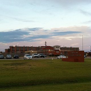
Clemens Unit (CN) is a prison farm of the Texas Department of Criminal Justice (TDCJ) in unincorporated Brazoria County, Texas, in Greater Houston. The prison, with about 8,008 acres (3,241 ha), is located at the intersection of Farm to Market Road 2004 and Texas State Highway 36. The prison, in the Texas Gulf Coast region, is in proximity to the City of Brazoria, and it is in proximity to the Velasco community, now a part of Freeport. The prison is situated south of Houston.

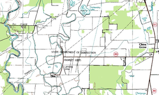
The Charles T. Terrell Unit is a Texas Department of Criminal Justice prison located in unincorporated Brazoria County, Texas, with a Rosharon, Texas postal address; it is not inside the Rosharon census-designated place. The facility is located on Farm to Market Road 655, 4 miles (6.4 km) west of Farm to Market Road 521. The prison, has about 16,369 acres (6,624 ha) of land, is co-located with Ramsey Unit and Stringfellow Unit. The prison is in Rosharon, and about 35 miles (56 km) south of Houston.
The Central Unit was a Texas Department of Criminal Justice (TDCJ) men's prison in Sugar Land, Texas. The approximately 325.8-acre (131.8 ha) facility is 2 miles (3.2 km) from the central part of the city of Sugar Land on U.S. Highway 90A.

Carol S. Vance Unit is a Texas Department of Criminal Justice (TDCJ) prison located in unincorporated central Fort Bend County, Texas. The unit, located in flatlands, is along U.S. Highway 90A, 4 miles (6.4 km) east of central Richmond. The facility is in proximity to Sugar Land, and it is about 20 miles (32 km) southwest of Downtown Houston. The unit, with about 940 acres (380 ha) of land, is co-located with Jester I Unit, Jester III Unit, and Jester IV Unit. The unit consists of four steel buildings and two brick buildings. The prison is the home of the Prison Fellowship Academy Christian prison program. It is located on the Jester State Prison Farm property.

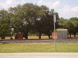
The Memorial Unit (DA), known as the Darrington Unit until 2021, is a Texas Department of Criminal Justice (TDCJ) men's prison located in Brazoria County, Texas, with a Rosharon, Texas postal address; it is not inside the Rosharon census-designated place. Most of the unit is in an unincorporated area, while a portion is in the city limits of Sandy Point.

The Retrieve Unit, later the Wayne Scott Unit, was a Texas Department of Criminal Justice (TDCJ) prison farm located in unincorporated Brazoria County, Texas. The unit, southwest of Houston, is along County Road 290, 8 miles (13 km) south of Angleton. Scott, which was established in September 1919, has about 5,766 acres (2,333 ha) of land.

The Louie C. Powledge Unit is a Texas Department of Criminal Justice (TDCJ) prison for men located in unincorporated Anderson County, Texas. The approximately 20,518-acre (8,303 ha) unit, co-located with the Beto, Coffield, and Michael prison units and the Gurney Unit transfer facility, is along Farm to Market Road 3452. The facility is located off of Farm to Market Road 645, 7 miles (11 km) west of Palestine.
The J. Dale Wainwright Unit is a Texas Department of Criminal Justice (TDCJ) prison for men, located in unincorporated Houston County, Texas. Formerly called the Eastham Unit or "The Ham," the prison was renamed the J. Dale Wainwright Unit after a former chairman of the Texas Board of Criminal Justice. The 12,789 acres (5,176 ha) prison is located on Farm to Market Road 230, near Lovelady and 13 miles (21 km) west of Trinity. the Wainwright Unit is 40 miles (64 km) up the Trinity River from the Polunsky Unit in West Livingston, and it is about one-third of the distance between Polunsky and the Christina Crain Unit in Gatesville. Robert Perkinson, author of Texas Tough: The Rise of America's Prison Empire, said that while the TDCJ and other agencies operate many types of prisons and jails in Texas, "if any unit stands for the rest," it would be Eastham.

Jim Ferguson Unit (FE) is a Texas Department of Criminal Justice prison for men located in unincorporated Madison County, Texas. The 4,355-acre (1,762 ha) prison is located on Farm to Market Road 247, near Midway and 20 miles (32 km) northwest of Huntsville.
The W. F. Ramsey Unit is a Texas Department of Criminal Justice prison farm located in unincorporated Brazoria County, Texas, with a Rosharon postal address; it is not inside the Rosharon census-designated place. The prison is located on Farm to Market Road 655, 4 miles (6.4 km) west of Farm to Market Road 521, and south of Houston. The 16,369-acre (6,624 ha) unit is co-located with the Stringfellow Unit and the Terrell Unit.

The Beauford H. Jester I Unit is a Texas Department of Criminal Justice substance abuse felony punishment facility (SAFPF) located in unincorporated Fort Bend County, Texas. The unit is situated at Harlem Road and Ken Drive, on about 940 acres (380 ha) of land, co-located with Carol Vance Unit, Jester III Unit, and Jester IV Unit which lie a little to its southeast. It is situated on the Jester State Prison Farm property. The current Warden is Lonnie Townsend.
The H. H. Coffield Unit (CO) is a Texas Department of Criminal Justice prison for men in unincorporated Anderson County, Texas. The prison, near Tennessee Colony, is along Farm to Market Road 2054. The unit, on a 20,518 acres (8,303 ha) plot of land, is co-located with Beto, Gurney, Michael, and Powledge units. With a capacity of 4,139 inmates, Coffield is the TDCJ's largest prison. Coffield opened in June 1965.
The Wayne Scott Unit (J4), formerly known as the Beauford H. Jester IV Unit, is a psychiatric facility of the Texas Department of Criminal Justice located in unincorporated Fort Bend County, Texas, 4 miles (6.4 km) east of Richmond. It is a part of the Jester State Prison Farm property and it is located on U.S. Highway 90A.