Unity, New Hampshire

Last updated

Unity, New Hampshire
Sullivan County New Hampshire incorporated and unincorporated areas Unity highlighted.svg
Location in Sullivan County and the state of New Hampshire.
Coordinates: 43°17′38″N72°15′37″W / 43.29389°N 72.26028°W / 43.29389; -72.26028
Country United States
State New Hampshire
County Sullivan
Incorporated 1764 [1]
VillagesUnity
East Unity
Quaker City
West Unity
Government
   Board of Selectmen
  • Garry Bator
  • Gary Ross
  • William A. Schroeter
Area
[2]
  Total37.20 sq mi (96.34 km2)
  Land36.98 sq mi (95.78 km2)
  Water0.22 sq mi (0.56 km2)  0.58%
Elevation
1,457 ft (444 m)
Population
 (2020)
  Total1,518
  Density41/sq mi (15.8/km2)
Time zone UTC-5 (Eastern)
  Summer (DST) UTC-4 (Eastern)
ZIP Codes
03603 (Charlestown)
03743 (Claremont)
03773 (Newport)
Area code 603
FIPS code 33-77940
GNIS feature ID0873742
Website www.townofunitynh.org

Unity is a town in Sullivan County, New Hampshire, United States. The population was 1,518 at the 2020 census, [3] down from 1,671 at the 2010 census. The town includes the villages of Unity, East Unity, Quaker City, and West Unity.

Contents

History

Prior to British colonization, the Connecticut River valley was populated by bands of the Western Abenaki, who lived in sometimes-large villages of longhouses. [4] Depending on the season, they would either remain near their villages to fish, gather plants, engage in sugaring, and trade or fight with their neighbors, or head to nearby fowling and hunting grounds. Later, they also farmed tobacco and the "three sisters": corn, beans, and squash. [4]

The Common c. 1904 The Common, Unity, NH.jpg
The Common c.1904

Colonization eventually resulted in the establishment of the Province of New Hampshire. Within that province, the area that is now Unity was part of a territory chartered in 1753 and named "Buckingham" after John Hobart, 1st Earl of Buckinghamshire. [1] Grants in the area were given by both the early Massachusetts government and by Governor Benning Wentworth, which led to disputes. The town was incorporated as "Unity" in 1764 after amicable resolutions of the disputes were reached. [1]

In the 1790 census, the town had 538 residents. [1] Unity was on the Second New Hampshire Turnpike, an important trade route chartered in 1799 that connected Amherst, New Hampshire, to Claremont. [5] By 1810, the town had 1,044 inhabitants, with two grain mills, five sawmills, a clothing mill and a distillery. Sheep farming was a principal business.

2008 presidential politics

"Unite for Change" Rally Obama unity.jpg
"Unite for Change" Rally

On June 27, 2008, Presidential candidate Barack Obama and former rival Hillary Clinton appeared together in Unity at their first public event since Clinton pulled out of the race to be the Democratic presidential candidate. [6] Unity was reportedly chosen because of the town's name and because, in the 2008 primary, Obama and Clinton each received 107 votes from Unity citizens. [6]

Geography

According to the U.S. Census Bureau, the town has a total area of 37.2 square miles (96.3 km2), of which 37.0 square miles (95.8 km2) are land and 0.2 square miles (0.6 km2) are water, comprising 0.58% of the town. Unity is entirely within the Connecticut River watershed. The western and central part of town is drained by the Little Sugar River, leading to the Connecticut at North Charlestown, while the northwestern corner and eastern end of the town are drained by tributaries of the Sugar River, which flows to the Connecticut in Claremont. Crescent Lake, lying along the town's southern border, is the source of the Cold River, which reaches the Connecticut River at North Walpole.

The highest point in Unity is an unnamed summit along the town's northern boundary, with an elevation of 2,011 feet (613 m) above sea level.

Adjacent municipalities

Demographics

Historical population
CensusPop.Note
1790 538
1800 90267.7%
1810 1,04415.7%
1820 1,27722.3%
1830 1,258−1.5%
1840 1,218−3.2%
1850 961−21.1%
1860 887−7.7%
1870 844−4.8%
1880 814−3.6%
1890 653−19.8%
1900 572−12.4%
1910 504−11.9%
1920 5223.6%
1930 501−4.0%
1940 66933.5%
1950 653−2.4%
1960 7088.4%
1970 7090.1%
1980 1,09254.0%
1990 1,34122.8%
2000 1,53014.1%
2010 1,6719.2%
2020 1,518−9.2%
U.S. Decennial Census [7]

As of the census [8] of 2000, there were 1,530 people, 504 households, and 385 families residing in the town. The population density was 41.4 inhabitants per square mile (16.0/km2). There were 594 housing units at an average density of 16.1 per square mile (6.2/km2). The racial makeup of the town was 99.35% White, 0.07% African American, 0.13% Asian, and 0.46% from two or more races. Hispanic or Latino of any race were 0.72% of the population.

There were 504 households, out of which 30.4% had children under the age of 18 living with them. 66.5% were married couples living together, 4.2% had a female householder with no husband present, and 23.6% were non-families. 17.1% of all households were made up of individuals, and 4.4% had someone living alone who was 65 years of age or older. The average household size was 2.59, and the average family size was 2.89.

In the town, the population was spread out, with 20.0% under the age of 18, 5.9% from 18 to 24, 27.5% from 25 to 44, 26.1% from 45 to 64, and 20.6% who were 65 years of age or older. The median age was 43 years. For every 100 females, there were 101.8 males. For every 100 females age 18 and over, there were 97.7 males.

The median income for a household in the town was $41,594, and the median income for a family was $47,045. Males had a median income of $31,199 versus $24,833 for females. The per capita income for the town was $17,908. About 6.8% of families and 8.1% of the population were below the poverty line, including 15.4% of those under age 18 and 1.4% of those age 65 or over.

Related Research Articles

<span class="mw-page-title-main">Sullivan County, New Hampshire</span> County in New Hampshire, United States

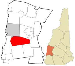
Sullivan County is a county in the U.S. state of New Hampshire. As of the 2020 census, the population was 43,063, making it the second-least populous county in New Hampshire. Its county seat is Newport.

<span class="mw-page-title-main">Westmoreland, New Hampshire</span> Town in New Hampshire, United States

Westmoreland is a town in Cheshire County, New Hampshire, United States. The population was 1,706 at the 2020 census, down from 1,874 at the 2010 census. Westmoreland is historically an agricultural town, with much arable farmland.

<span class="mw-page-title-main">Clarksville, New Hampshire</span> Town in New Hampshire, United States

Clarksville is a town in northern Coös County, New Hampshire, United States. The population was 294 at the 2020 census. It is part of the Berlin, NH-VT Micropolitan Statistical Area.

<span class="mw-page-title-main">Columbia, New Hampshire</span> Town in New Hampshire, United States

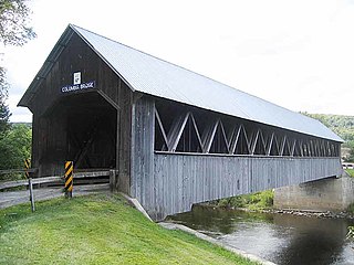
Columbia is a town in Coös County, New Hampshire, United States. The population was 659 at the 2020 census, down from 757 at the 2010 census. It is part of the Berlin, NH-VT micropolitan statistical area.

<span class="mw-page-title-main">Stewartstown, New Hampshire</span> Town in New Hampshire, United States

Stewartstown is a town in Coös County, New Hampshire, United States. The population was 813 at the 2020 census, down from 1,004 at the 2010 census. It includes the village of West Stewartstown and is part of the Berlin, NH-VT Micropolitan Statistical Area.

<span class="mw-page-title-main">Acworth, New Hampshire</span> Town in New Hampshire, United States

Acworth is a town in Sullivan County, New Hampshire, United States. At the 2020 census, the town had a total population of 853.

<span class="mw-page-title-main">Claremont, New Hampshire</span> City in New Hampshire, United States

Claremont is the only city in Sullivan County, New Hampshire, United States. The population was 12,949 at the 2020 census.

<span class="mw-page-title-main">Cornish, New Hampshire</span> Town in New Hampshire, United States

Cornish is a town in Sullivan County, New Hampshire, United States. The population was 1,616 at the 2020 census. Cornish has four covered bridges. Each August, it is home to the Cornish Fair.

<span class="mw-page-title-main">Goshen, New Hampshire</span> Place in New Hampshire, United States

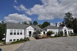
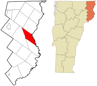
Goshen is a town in Sullivan County, New Hampshire, United States. The population was 796 at the 2020 census.

<span class="mw-page-title-main">Langdon, New Hampshire</span> Place in New Hampshire, United States

Langdon is a town in Sullivan County, New Hampshire, United States. The population was 651 at the 2020 census.

<span class="mw-page-title-main">Lempster, New Hampshire</span> Place in New Hampshire, United States

Lempster is a town in Sullivan County, New Hampshire, United States. The population was 1,118 at the 2020 census. Settlements include the town center and the village of East Lempster.

<span class="mw-page-title-main">Springfield, New Hampshire</span> Place in New Hampshire, United States

Springfield is a town in Sullivan County, New Hampshire, United States. The population was 1,259 at the 2020 census. Gile State Forest is located within the town.

<span class="mw-page-title-main">Brunswick, Vermont</span> Town in Vermont, United States

Brunswick is a town in Essex County, Vermont, United States. The town was named after Prince Karl Wilhelm Ferdinand of Brunswick-Lunenburg. The population was 88 at the 2020 census. It is part of the Berlin, NH-VT Micropolitan Statistical Area. Brunswick is home to six mineral springs that made the town a popular resort destination in the 19th century. The land the springs are on is now owned by the Abenaki people.

<span class="mw-page-title-main">Maidstone, Vermont</span> Town in Vermont, United States

Maidstone is a town in Essex County, Vermont, United States. As of the 2020 census, the town had a population of 211. It is part of the Berlin, NH–VT Micropolitan Statistical Area. There is no town center or gas station, but there is a town office building in the southern part of the town.

<span class="mw-page-title-main">Reading, Vermont</span> Town in Vermont, United States

Reading is a town in Windsor County, Vermont, United States. The population was 687 at the 2020 census.

<span class="mw-page-title-main">Charlestown (CDP), New Hampshire</span> Census-designated place in New Hampshire, United States

Charlestown is a census-designated place (CDP) and the main village in the town of Charlestown, Sullivan County, New Hampshire, United States. The population of the CDP was 1,078 at the 2020 census, out of 4,806 in the entire town.

<span class="mw-page-title-main">Charlestown, New Hampshire</span> Place in New Hampshire, United States

Charlestown is a town in Sullivan County, New Hampshire, United States. The population was 4,806 at the 2020 census, down from 5,114 at the 2010 census. The town is home to Hubbard State Forest and the headquarters of the Student Conservation Association.

<span class="mw-page-title-main">Newport, New Hampshire</span> Place in New Hampshire, United States

Newport is a town in and the county seat of Sullivan County, New Hampshire, United States. It is 43 miles (69 km) west-northwest of Concord, the state capital. The population of Newport was 6,299 at the 2020 census. A covered bridge is in the northwest. The area is noted for maple sugar and apple orchards. Prior to county division in 1827, Newport was in Cheshire County. The central part of town, where 4,735 people resided at the 2020 census, is defined as the Newport census-designated place (CDP) and is located next to the Sugar River at the junction of New Hampshire routes 10 and 11. The town also includes the villages of Kelleyville, Guild, and North Newport.

<span class="mw-page-title-main">North Walpole, New Hampshire</span> Census-designated place in New Hampshire, United States

North Walpole is a census-designated place (CDP) in the town of Walpole in Cheshire County, New Hampshire, United States. It had a population of 785 at the 2020 census, making it the largest village in the town of Walpole.

<span class="mw-page-title-main">Walpole (CDP), New Hampshire</span> Census-designated place in New Hampshire, United States

Walpole is a census-designated place (CDP) and the central village in the town of Walpole in Cheshire County, New Hampshire, United States. The population of the CDP was 573 at the 2020 census, compared to 3,633 in the entire town.

References

  1. 1 2 3 4 Profile of Unity from the website of the state's Economic and Labor Market Information Bureau
  2. "2021 U.S. Gazetteer Files – New Hampshire". United States Census Bureau. Retrieved January 10, 2022.
  3. "Census - Geography Profile: Unity town, Sullivan County, New Hampshire" . Retrieved December 25, 2021.
  4. 1 2 Native Americans in Vermont: the Abenaki Archived July 14, 2006, at the Wayback Machine , from flowofhistory.org, a website funded by educational grants
  5. Technology and Transportation: 1790-1870, from flowofhistory.org
  6. 1 2 Clinton and Obama rally together, a June 27, 2008, article from the BBC News website
  7. "Census of Population and Housing". Census.gov. Retrieved June 4, 2016.
  8. "U.S. Census website". United States Census Bureau . Retrieved January 31, 2008.