Wales, Utah

Last updated

Wales, Utah
Wales Utah Community Hall.jpeg
Wales Community Hall, November 2019
Sanpete County Utah incorporated and unincorporated areas Wales highlighted.svg
Location in Sanpete County and the state of Utah.
Coordinates: 39°29′10″N111°38′10″W / 39.48611°N 111.63611°W / 39.48611; -111.63611
Country United States
State Utah
County Sanpete
Founded1859
Named for Wales, the ancestral land of a large share of the early settlers [1]
Area
[2]
  Total0.40 sq mi (1.03 km2)
  Land0.40 sq mi (1.03 km2)
  Water0.00 sq mi (0.00 km2)
Elevation
5,627 ft (1,715 m)
Population
 (2010)
  Total302
  Estimate 
(2019) [3]
373
  Density939.55/sq mi (362.55/km2)
Time zone UTC-7 (Mountain (MST))
  Summer (DST) UTC-6 (MDT)
ZIP code
84667
Area code 435
FIPS code 49-80860 [4]
GNIS feature ID1446954 [5]
Website www.walesutah.org

Wales is a town in Sanpete County, Utah, United States. The population was 219 at the 2000 census. The town is governed by a mayor and several council members. As of December 2008, Wales had no stores, gas stations nor stop lights. It does have a park, fire station, library and cemetery.

Contents

Description

The small mining town of Wales was named for the country of the immigrants that were sent there by Brigham Young in 1854 to mine the "rock that burns". A Native American named Tabison, a prominent Ute, had shown Young, then president of The Church of Jesus Christ of Latter-day Saints, a small sample. Young recognized it as coal and asked if any of his group knew how to mine the coal. Some Welsh immigrants including John Evans Rees and his cousin John Price, having experience with coal mining in the U.K., volunteered and were sent to the west side hills to set up mines.

The community's original name was Coal Bed, but was changed to Wales in 1857. There once was a railroad depot and it was an important and busy mining center. The mines and train were abandoned when more productive mines were discovered in Scofield. Many of the present residents are descendants of the original miners.

Wales lies on the west side of the Sanpete Valley, at the foot of the San Pitch Mountains.

Geography

According to the United States Census Bureau, the town has a total area of 0.3 square mile (0.8 km2), all land.

Demographics

Historical population
CensusPop.Note
1870 83
1880 306268.7%
1890 233−23.9%
1900 33142.1%
1910 294−11.2%
1920 280−4.8%
1930 243−13.2%
1940 223−8.2%
1950 179−19.7%
1960 130−27.4%
1970 89−31.5%
1980 15371.9%
1990 18923.5%
2000 21915.9%
2010 30237.9%
2019 (est.)373 [3] 23.5%
U.S. Decennial Census [6]

As of the census [4] of 2000, there were 219 people, 64 households, and 54 families residing in the town. The population density was 731.4 people per square mile (281.9/km2). There were 84 housing units at an average density of 280.5 per square mile (108.1/km2). The racial makeup of the town was 97.26% White, 0.46% Pacific Islander, 1.83% from other races, and 0.46% from two or more races. Hispanic or Latino of any race were 7.31% of the population.

There were 64 households, out of which 43.8% had children under the age of 18 living with them, 78.1% were married couples living together, 6.3% had a female householder with no husband present, and 14.1% were non-families. 12.5% of all households were made up of individuals, and 6.3% had someone living alone who was 65 years of age or older. The average household size was 3.42 and the average family size was 3.73.

In the town, the population was spread out, with 34.2% under the age of 18, 12.8% from 18 to 24, 21.9% from 25 to 44, 18.3% from 45 to 64, and 12.8% who were 65 years of age or older. The median age was 26 years. For every 100 females, there were 110.6 males. For every 100 females age 18 and over, there were 111.8 males.

The median income for a household in the town was $35,313, and the median income for a family was $38,750. Males had a median income of $28,125 versus $16,250 for females. The per capita income for the town was $9,885. About 3.7% of families and 6.0% of the population were below the poverty line, including 8.8% of those under the age of eighteen and 19.0% of those 65 or over.

See also

Related Research Articles

<span class="mw-page-title-main">Sesser, Illinois</span> City in Illinois, United States

Sesser is a city in Franklin County, Illinois, United States. The population was 1,931 at the 2010 census. The current mayor is C. Jason Ashmore.

<span class="mw-page-title-main">Coalville, Iowa</span> CDP in Iowa, United States

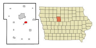
Coalville is a census-designated place (CDP) in Webster County, Iowa, United States. The population was 610 at the 2010 census. The community is located on U.S. Route 20 near Fort Dodge's large gypsum mines.

<span class="mw-page-title-main">Barton, Maryland</span> Town in Maryland, United States

Barton is a town in Allegany County, Maryland, United States, located along the Georges Creek Valley. It is part of the Cumberland, MD-WV Metropolitan Statistical Area. The population was 457 at the 2010 census.

<span class="mw-page-title-main">New Straitsville, Ohio</span> Village in Ohio, United States

New Straitsville is a village in Perry County, Ohio, United States. The population was 652 at the 2020 census.

Rossiter is a Census-designated place (CDP) in Indiana County, Pennsylvania, United States. The population was 646 at the 2010 census.

<span class="mw-page-title-main">Glen Lyon, Pennsylvania</span> Census-designated place in Pennsylvania, United States

Glen Lyon is a census-designated place (CDP) in Newport Township, Luzerne County, Pennsylvania, United States. The population was 1,873 at the 2010 census.

<span class="mw-page-title-main">Marianna, Pennsylvania</span> Borough in Pennsylvania, United States

Marianna is a borough in Washington County, Pennsylvania, United States. The population was 396 at the 2020 census.

<span class="mw-page-title-main">Crabtree, Pennsylvania</span> CDP in Pennsylvania, United States

Crabtree is a census-designated place (CDP) and former coal town in Salem Township, Westmoreland County, Pennsylvania, United States. The population was 277 at the 2010 census. It has its own post office, with postal code 15624.

<span class="mw-page-title-main">Sunnyside, Utah</span> Former city in Utah, United States

Sunnyside is a former city in Carbon County, Utah, United States. The population was 377 at the 2010 census. On January 1, 2014, the city merged with the neighboring city of East Carbon.

<span class="mw-page-title-main">Huntington, Utah</span> City in Utah, United States

Huntington is a city in northwestern Emery County, Utah, United States. The population was 2,129 at the 2010 census. It is the largest town in Emery County.

<span class="mw-page-title-main">Orangeville, Utah</span> City in Utah, United States

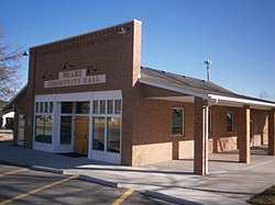
Orangeville is a city in northwestern Emery County, Utah, United States, at the edge of the Manti-La Sal National Forest. The city is at the junction of State Routes 29 and 57, straddling the banks of Cottonwood Creek. The population was 1,470 at the 2010 census.

<span class="mw-page-title-main">Ephraim, Utah</span> City in Utah, United States

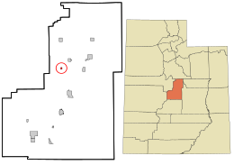
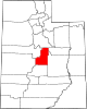
Ephraim is a city in Sanpete County, Utah, United States. The population was 5,611 at the 2020 census, making it the largest city in Sanpete County. It is the location of Snow College and is located along U.S. Route 89.

<span class="mw-page-title-main">Fairview, Utah</span> City in Utah, United States

Fairview is a city in northern Sanpete County, Utah, United States. The population was 1,203 at the 2020 census.

<span class="mw-page-title-main">Mayfield, Utah</span> Town in the state of Utah, United States

Mayfield is a town in southwestern Sanpete County, Utah, United States. The population was 496 at the 2010 census.

<span class="mw-page-title-main">Moroni, Utah</span> City in Utah, United States

Moroni is a city in Sanpete County, Utah, United States. The population was 1,423 at the 2010 census.

<span class="mw-page-title-main">Mount Pleasant, Utah</span> City in Utah, United States

Mount Pleasant is a city in the U.S. state of Utah. Located in Sanpete County, Mt. Pleasant is known for being home to Wasatch Academy. As of the 2010 census, the city population was 3,260.

<span class="mw-page-title-main">Sterling, Utah</span> Town in Utah, United States

Sterling is a town in Sanpete County, Utah, United States. The population was 235 at the 2000 census.

<span class="mw-page-title-main">Grant Town, West Virginia</span> Town in West Virginia, United States

Grant Town is a town in Marion County, West Virginia, in the eastern United States. The population was 690 at the 2020 census.

<span class="mw-page-title-main">Delbarton, West Virginia</span> Town in West Virginia, United States

Delbarton is a town in Mingo County, West Virginia, United States. The population was 522 at the 2020 census.

<span class="mw-page-title-main">Wright, Wyoming</span> Town in Wyoming, United States

Wright is a town in Campbell County, Wyoming, United States. The population was 1,807 at the 2010 census.

References

  1. Van Atta, Dale (January 22, 1977). "You name it - there's a town for it". The Deseret News. pp. W6. Retrieved October 18, 2015.
  2. "2019 U.S. Gazetteer Files". United States Census Bureau. Retrieved August 7, 2020.
  3. 1 2 "Population and Housing Unit Estimates". United States Census Bureau. May 24, 2020. Retrieved May 27, 2020.
  4. 1 2 "U.S. Census website". United States Census Bureau . Retrieved January 31, 2008.
  5. "US Board on Geographic Names". United States Geological Survey. October 25, 2007. Retrieved January 31, 2008.
  6. "Census of Population and Housing". Census.gov. Retrieved June 4, 2015.