Winchester, Adams County, Ohio

Last updated

Winchester, Ohio
Dr. A.C. Lewis House.jpg
Dr. A.C. Lewis House, listed on the National Register of Historic Places, located at 103 E. South Street in Winchester
Adams County Ohio incorporated and unincorporated areas Winchester highlighted.svg
Location in Adams County and the state of Ohio.
Coordinates: 38°56′37″N83°39′14″W / 38.94361°N 83.65389°W / 38.94361; -83.65389
Country United States
State Ohio
County Adams
Area
[1]
  Total2.63 sq mi (6.82 km2)
  Land2.62 sq mi (6.78 km2)
  Water0.02 sq mi (0.04 km2)
Elevation
[2]
978 ft (298 m)
Population
 (2020)
  Total987
  Density377.29/sq mi (145.67/km2)
Time zone UTC-5 (Eastern (EST))
  Summer (DST) UTC-4 (EDT)
ZIP code
45697
Area codes 937, 326
FIPS code 39-85876
GNIS feature ID2399711 [2]

Winchester is a village in Adams County, Ohio, United States. The population was 987 at the 2020 census. The name of the surrounding township is also named Winchester.

Contents

State Route 136 passes through Winchester. Winchester is adjacent to Ohio State Route 32, a four lane divided highway known as the Appalachian Highway. The Appalachian Highway links Winchester to Cincinnati.

History

Winchester was laid out in 1815 by Joseph Darlinton. It was named for Darlinton's former hometown of Winchester, Virginia. [3]

There is also an Ohio Historic Site in Winchester, the Dr. A. C. Lewis House. The Dr. A. C. Lewis home was built between 1845 and 1848. Dr. Lewis is considered the first resident physician of Winchester. He was a known abolitionist and used the house as a station on the underground railroad.

Geography

According to the United States Census Bureau, the village has a total area of 2.63 square miles (6.81 km2), of which 2.61 square miles (6.76 km2) is land and 0.02 square miles (0.05 km2) is water. [4]

Demographics

Historical population
CensusPop.Note
1870 416
1880 55032.2%
1900 796
1910 92716.5%
1920 913−1.5%
1930 821−10.1%
1940 798−2.8%
1950 690−13.5%
1960 78814.2%
1970 760−3.6%
1980 1,08042.1%
1990 978−9.4%
2000 1,0254.8%
2010 1,0512.5%
2020 987−6.1%
U.S. Decennial Census [5]

2010 census

As of the census [6] of 2010, there were 1,051 people, 420 households, and 273 families living in the village. The population density was 402.7 inhabitants per square mile (155.5/km2). There were 462 housing units at an average density of 177.0 per square mile (68.3/km2). The racial makeup of the village was 98.4% White, 0.2% African American, 0.5% Native American, 0.3% from other races, and 0.7% from two or more races. Hispanic or Latino of any race were 1.0% of the population.

There were 420 households, of which 34.0% had children under the age of 18 living with them, 45.7% were married couples living together, 13.1% had a female householder with no husband present, 6.2% had a male householder with no wife present, and 35.0% were non-families. 31.2% of all households were made up of individuals, and 13.3% had someone living alone who was 65 years of age or older. The average household size was 2.48 and the average family size was 3.05.

The median age in the village was 35.9 years. 27.3% of residents were under the age of 18; 9.3% were between the ages of 18 and 24; 25.9% were from 25 to 44; 22% were from 45 to 64; and 15.6% were 65 years of age or older. The gender makeup of the village was 49.0% male and 51.0% female.

2000 census

As of the census [7] of 2000, there were 1,025 people, 410 households, and 280 families living in the village. The population density was 381.8 inhabitants per square mile (147.4/km2). There were 448 housing units at an average density of 166.9 per square mile (64.4/km2). The racial makeup of the village was 99.02% White, 0.20% Native American, 0.39% Asian, and 0.39% from two or more races. Hispanic or Latino of any race were 0.49% of the population.

There were 410 households, out of which 34.9% had children under the age of 18 living with them, 52.4% were married couples living together, 11.0% had a female householder with no husband present, and 31.5% were non-families. 27.6% of all households were made up of individuals, and 13.7% had someone living alone who was 65 years of age or older. The average household size was 2.50 and the average family size was 3.06.

In the village, the population was spread out, with 28.4% under the age of 18, 8.7% from 18 to 24, 28.4% from 25 to 44, 20.3% from 45 to 64, and 14.2% who were 65 years of age or older. The median age was 34 years. For every 100 females, there were 89.1 males. For every 100 females age 18 and over, there were 85.4 males.

The median income for a household in the village was $32,344, and the median income for a family was $36,750. Males had a median income of $33,036 versus $19,028 for females. The per capita income for the village was $16,711. About 9.5% of families and 14.2% of the population were below the poverty line, including 15.2% of those under age 18 and 18.4% of those age 65 or over.

Related Research Articles

<span class="mw-page-title-main">Adams County, Ohio</span> County in Ohio, United States

Adams County is a county in the U.S. state of Ohio. As of the 2020 census, the population was 27,477. Its county seat and largest village is West Union. The county is named after John Adams, the second President of the United States.

<span class="mw-page-title-main">Cairo, Ohio</span> Village in Ohio, United States

Cairo is a village in Allen County, Ohio, United States. As of the 2020 census it had a population of 517. It is included in the Lima Metropolitan Statistical Area.

<span class="mw-page-title-main">Neville, Ohio</span> Village in Ohio, United States

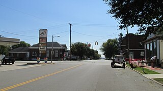
Neville is a village in Clermont County, Ohio, United States, along the Ohio River. The population was 87 at the 2020 census.

<span class="mw-page-title-main">Midland, Ohio</span> Village in Ohio, United States

Midland is a village in Clinton County, Ohio, United States. The population was 307 at the 2020 census.

<span class="mw-page-title-main">Castine, Ohio</span> Village in Ohio, United States

Castine is a village in Darke County, Ohio, United States. The population was 110 at the 2020 census.

<span class="mw-page-title-main">Gordon, Ohio</span> Village in Ohio, United States

Gordon is a village in Darke County, Ohio, United States. The population was 245 at the 2020 census.

<span class="mw-page-title-main">Ithaca, Ohio</span> Village in Ohio, United States

Ithaca is a village in Darke County, Ohio, United States. The population was 81 at the 2020 census.

<span class="mw-page-title-main">Palestine, Ohio</span> Village in Ohio, United States

Palestine is a village in Darke County, Ohio, United States. The population was 180 at the 2020 census.

<span class="mw-page-title-main">Jeffersonville, Ohio</span> Village in Ohio, United States

Jeffersonville is a village in Fayette County, Ohio, United States. The population was 1,258 at the 2020 census.

<span class="mw-page-title-main">Addyston, Ohio</span> Village in Ohio, United States

Addyston is a village in Miami Township, Hamilton County, Ohio, United States. Located along the Ohio River, it is a western suburb of the neighboring city of Cincinnati. The population was 927 at the 2020 census.

<span class="mw-page-title-main">Cleves, Ohio</span> City in Ohio, United States

Cleves is a village in Miami Township, Hamilton County, Ohio, United States. Located along the Ohio River, it is a western suburb of Cincinnati. The population was 3,414 at the 2020 census.

<span class="mw-page-title-main">Evendale, Ohio</span> Village in Ohio, United States

Evendale is a village in Hamilton County, Ohio, United States, within the Cincinnati metropolitan area. The population was 2,669 at the 2020 census.

<span class="mw-page-title-main">Lockland, Ohio</span> Village in Ohio, United States

Lockland is a village in Hamilton County, Ohio, United States. The population was 3,514 at the 2020 United States Census. Lockland is located in southwest Ohio, north of Cincinnati.

<span class="mw-page-title-main">North Bend, Ohio</span> Village in Ohio, United States

North Bend is a village in Miami Township, Hamilton County, Ohio, United States, along the Ohio River. It is a part of the Greater Cincinnati area. The population was 835 at the 2020 census.

<span class="mw-page-title-main">Gann, Ohio</span> Village in Ohio, United States

Brinkhaven, once known as Mount Holly and Gann, is a village in Knox County, Ohio, United States. The population was 114 at the 2020 census.

<span class="mw-page-title-main">Hanging Rock, Ohio</span> Village in Ohio, United States

Hanging Rock is a village in Lawrence County, Ohio, United States, along the Ohio River. The population was 204 at the 2020 census. It is regularly labeled a speed trap; the village earned revenues of $109,186 in mayor's court receipts in 2000, compared with $3,106 in property taxes.

<span class="mw-page-title-main">Darbyville, Ohio</span> Village in Ohio, United States

Darbyville is a village in Pickaway County, Ohio, United States. The population was 186 at the 2020 census.

<span class="mw-page-title-main">Clarksburg, Ohio</span> Village in Ohio, United States

Clarksburg is a village in Ross County, Ohio, United States. The population was 409 at the 2020 census.

<span class="mw-page-title-main">Canal Winchester, Ohio</span> City in Ohio, United States

Canal Winchester is a city in Fairfield and Franklin counties in the U.S. state of Ohio. The city is one of the suburbs that make up the Columbus metropolitan area. The population was 9,107 at the 2020 census.

<span class="mw-page-title-main">Verona, Ohio</span> Village in Ohio, United States

Verona is a village in Montgomery and Preble counties in the U.S. state of Ohio. The population was 403 at the 2020 census. It is part of the Dayton Metropolitan Statistical Area.

References

  1. "ArcGIS REST Services Directory". United States Census Bureau. Retrieved September 20, 2022.
  2. 1 2 U.S. Geological Survey Geographic Names Information System: Winchester, Adams County, Ohio
  3. Evans, Nelson Wiley (1900). A History of Adams County, Ohio: From Its Earliest Settlement to the Present Time. E B. Stivers. p. 498.
  4. "US Gazetteer files 2010". United States Census Bureau . Retrieved January 6, 2013.
  5. "Census of Population and Housing". Census.gov. Retrieved June 4, 2015.
  6. "U.S. Census website". United States Census Bureau . Retrieved January 6, 2013.
  7. "U.S. Census website". United States Census Bureau . Retrieved January 31, 2008.