Wolf Creek Dam

Last updated
Wolf Creek Dam
Wolf Creek Dam.jpg
USA Kentucky relief location map.svg
Red pog.svg
Location of Wolf Creek Dam in Kentucky
Location Russell County, Kentucky
Coordinates 36°52′06″N85°08′51″W / 36.8683°N 85.1475°W / 36.8683; -85.1475
Construction began1941
Opening date1951
Operator(s) U.S. Army Corps of Engineers
Dam and spillways
Impounds Cumberland River
Height258  ft (79  m) [1]
Length5,736  ft (1,748  m) [1]
Dam volume11,396,500 cu yd (8,713,200 m3) [1]
Reservoir
Creates Lake Cumberland
Total capacity6,089,000  acre⋅ft (7,511,000 dam3) [1]
Catchment area 5,789 sq mi (14,990 km2) [1]
Surface area50,250 acres (20,340 ha) [1]
Power Station
Turbines 6x 45.0 MW
Installed capacity 270 MW

The Wolf Creek Dam is a multi-purpose dam on the Cumberland River in the western part of Russell County, Kentucky, United States. The dam serves at once four distinct purposes: it generates hydroelectricity; it regulates and limits flooding; it releases stored water to permit year-round navigation on the lower Cumberland River; and it creates Lake Cumberland for recreation, the largest man made lake by volume East of the Mississippi river. The Lake has become a popular tourist attraction.U.S. Route 127 is built on top of the dam.

Contents

Electricity from the dam is marketed by the Southeastern Power Administration. [2]

Construction

Construction of the Wolf Creek Dam was authorized by the Flood Control Act of 1938 and the River Harbor Act of 1946 as part of a comprehensive plan to develop the Cumberland River Basin. Construction began in 1941 but because of World War II and other factors, construction was not completed until 1951. [3] Lake Cumberland is one of four major flood control reservoirs for the Cumberland; the others being J. Percy Priest Dam, Dale Hollow Dam, and Center Hill Dam. [4] The last of the power generators was installed in 1952.

While several small towns were adversely affected by the construction of the dam, such as nearby Creelsboro (downstream) and Burnside (upstream), the dam is credited with preventing several hundred million dollars in flood damage.

Characteristics

Wolf Creek Dam, 2011 Wolf Creek Dam - 2011.jpg
Wolf Creek Dam, 2011
Water was released through the floodgates--at a rate of 6,000 cubic feet per second (170 m/s)--for the first time in 11 years, in March 2015 Wolf Creek Dam (2015).jpg
Water was released through the floodgatesat a rate of 6,000 cubic feet per second (170 m/s)for the first time in 11 years, in March 2015

The Wolf Creek Dam is a 5,736  ft (1,748  m ) long and 258  ft (79  m ) high dam with a combined earthen and concrete structure. The concrete section of the Wolf Creek Dam consists of 37 gravity monoliths that comprise 1,794.62  ft (547.00  m ) of the dam's length, across the old river channel. The spillway section contains ten 49.2126  ft × 36.0892 ft (15.0000  m × 11.0000 m) tainter gates and six 3.937  ft × 5.9055 ft (1.2000  m × 1.8000 m) low level sluice gates. The power intake section contains the penstocks that feed the six 45 MW turbines. The embankment section extends from the end of the concrete gravity portion 3,937.008  ft (1,200.000  m ) across the valley to the right abutment. It has a maximum height of 213.2546  ft (65.0000  m ) above the top of rock. The non-zoned embankment is composed of well-compacted, low plasticity clays, from the valley alluvium. [6]

Seepage

In 1968, signs of seepage problems within Wolf Creek Dam's earthen embankments and foundation were discovered. Sinkholes appeared at the downstream toe of the dam, and muddy water was observed in the dam's outflow channel. The seepage problems were traced to the karst geology of the region which allows for the dissolution of limestone in the dam's foundation. [7] Solution channels caused by this process allow piping to occur, which adds to the rate of erosion in the foundation.

The dam and its adjacent reservoir reside upon a heavy Karst bedrock foundation. Karst formations are large void spaces lying beneath seemingly solid species of limestone bedrock. Karst formations are created when limestone bedrocks are, over time, attacked by water through natural precipitation seepage. The rain or snowmelt water contains dissolved carbon dioxide from the atmosphere, which, in solution, forms a weak carbonic acid. That acid attacks the limestone rock dissolving it and thereby leading to the voids within the rock formation. When a reservoir of 100+ feet in elevation is raised above this style of foundation, the hydraulic pressure of the water easily dislodges the cementing clays that are in the cracks and void spaces of the underlying Karst foundation.

Keying a concrete dam's footing form into such a foundation; along with injecting waterproof grout into the void spaces between the dam's concrete base and the rock foundation (so as to fill the foundation's voids) will usually create a watertight seal above, at, and below the foundation of a concrete dam, in a Karst locale.

However Wolf Creek is primarily an earth fill embankment dam. In this form of construction the majority of the dam's structure (measured by length across the streambed) is a nominally waterproof earth fill embankment body, with only the powerhouse and (if so equipped) the controlled overflow spillway section located within a concrete monolith. In the particular case of Wolf Creek dam, the earth embankment section is placed directly upon the formerly existing streambed; with only the surface soils and clays removed. While the upstream interface between the embankment section's foot and the old streambed is nominally waterproof, the Karst solution channels far under the mass of the earth embankment section proper, can directly attack the porous and not waterproofed foundation of the earth embankment section of the dam. It is this phenomenon that has occurred and led directly to the seepage problem.

A short-term solution of grouting the existing seepage channels was employed immediately; grouting in the dam foundation ran from 1968 to 1970 and is credited with saving the dam. [7] Construction of a long-term solution began in 1975 in the form of a seepage cut-off wall. A concrete diaphragm wall was chosen as the appropriate cut-off solution and extended through the earth embankment into the rock foundation. The cut-off wall was completed in 1979.

Recent events

Despite efforts to stem the seepage, continuous monitoring of the dam shows that seepage problems have not been completely alleviated and are increasing. Reports of seepage has caused public worry and if Wolf Creek Dam fails, the USACE estimates US$3 billion in property damage. [8] Seepage has likely found new paths around, and possibly through, the cut-off wall previously placed. [7] [9] Since March 2005, around the time when increased seepage rates were discovered, Lake Cumberland has been held at nearly constant water levels to reduce the stresses placed on the structure and its foundation.

In late January 2007, the U.S. Army Corps of Engineers placed the dam under a 'high risk' for failure designation, along with Center Hill Dam in Tennessee, both of which are two major dams upstream from Nashville, Tennessee. A new long-term solution was proposed to solve, or control, the current seepage problem. A grout curtain and a new concrete diaphragm wall of greater dimensions will be constructed with newer technologies. [9] To reduce the stresses on Wolf Creek Dam, and thus the risk, the Corps planned to lower Lake Cumberland to 640 ft (200 m), 83 ft (25 m) lower than normal summer levels. [10] However, this will affect up to 200,000 area citizens' water supply and has also met resistance from marina owners, so the water level has remained at 40 ft (12 m) below normal. This 40 ft. lowered lake level is to be held for an indefinite amount of time and will be subject to frequent review. [9] In October 2007, warning sirens were installed in counties downstream from the dam. [11] [12] Phase one remedial work began in March 2006. Phase two, which includes grouting the dam's foundation, began in January 2007. [9]

In April 2009, construction began on a new concrete barrier wall within the embankment of the Wolf Creek Dam. The concrete wall was planned for completion in 2012 at a cost of US$584 million. [6] A risk-benefit analysis suggests a 7:1 benefit. [7] In 2010, the Commonwealth of Kentucky proposed a new route for US 127 that would cross the Cumberland River in the first bend downstream, potentially removing traffic from atop the dam. Timing of the project is uncertain. [13] The barrier wall begun in 2009 was completed in 2013 and lake levels returned to normal in 2014. [14]

Related Research Articles

<span class="mw-page-title-main">Dam</span> Barrier that stops or restricts the flow of surface or underground streams

A dam is a barrier that stops or restricts the flow of surface water or underground streams. Reservoirs created by dams not only suppress floods but also provide water for activities such as irrigation, human consumption, industrial use, aquaculture, and navigability. Hydropower is often used in conjunction with dams to generate electricity. A dam can also be used to collect or store water which can be evenly distributed between locations. Dams generally serve the primary purpose of retaining water, while other structures such as floodgates or levees are used to manage or prevent water flow into specific land regions.

<span class="mw-page-title-main">Gravity dam</span> Type of dam that uses mass to counteract water pressure

A gravity dam is a dam constructed from concrete or stone masonry and designed to hold back water by using only the weight of the material and its resistance against the foundation to oppose the horizontal pressure of water pushing against it. Gravity dams are designed so that each section of the dam is stable and independent of any other dam section.

<span class="mw-page-title-main">Diamond Valley Lake</span> Reservoir in Riverside County, California, United States

Diamond Valley Lake is a man-made off-stream reservoir located near Hemet, California, United States. It is one of the largest reservoirs in Southern California and one of the newest. It has a capacity of 800,000 acre-feet (990,000,000 m3). The lake nearly doubled the area's surface water storage capacity and provides additional water supplies for drought, peak summer, and emergency needs.

<span class="mw-page-title-main">Lake Cumberland</span> Man-made lake in Kentucky, United States

Lake Cumberland is a reservoir in Clinton, Pulaski, Russell, Wayne, and Laurel, counties in Kentucky. The primary reasons for its construction were a means for flood control and the production of hydroelectric power. Its shoreline measures 1,255 miles (2,020 km) and the lake covers 65,530 acres (265 km2) at the maximum power pool elevation. The reservoir ranks 9th in the U.S. in size, with a capacity of 6,100,000 acre-feet (7.5 km3) of water, enough to cover the entire Commonwealth of Kentucky with 3 inches (76 mm) of water. The main lake is 101 miles (163 km) long and over one mile (1.6 km) across at its widest point.

<span class="mw-page-title-main">Center Hill Lake</span> Reservoir in Tennessee, United States

Center Hill Lake is a reservoir in the U.S. state of Tennessee. It is located in Middle Tennessee near Smithville. Created by means of a dam constructed by the U.S. Army Corps of Engineers in 1948, the lake has a dual purpose: electricity production and flood control. Center Hill Dam is 260 ft (79 m) high, and it is composed of concrete and earth structures, with 8 gates that are 50 ft (15 m) wide each. Center Hill Lake is one of four major flood control reservoirs for the Cumberland; the others being Percy Priest Lake, Dale Hollow Reservoir, and Lake Cumberland.

<span class="mw-page-title-main">J. Percy Priest Dam</span> Dam in Tennessee

J. Percy Priest Dam is a dam in north central Tennessee at river mile 6.8 of the Stones River, a tributary of the Cumberland. It is located about ten miles (16 km) east of downtown Nashville. The reservoir behind the dam is Percy Priest Lake. It is one of four major flood control reservoirs for the Cumberland; the others being Wolf Creek Dam, Dale Hollow Dam, and Center Hill Dam.

<span class="mw-page-title-main">Pomme de Terre Lake</span> Flood control reservoir in Missouri, United States

Pomme de Terre Lake is located in southwest Missouri at the confluence of Lindley Creek and the Pomme de Terre River. The lake is located in southern Hickory and northern Polk counties, about 50 miles (80 km) north of Springfield. Its name is the French language word for potato.

<span class="mw-page-title-main">Tuttle Creek Lake</span> Kansas reservoir on the Big Blue River

Tuttle Creek Lake is a reservoir on the Big Blue River 5 miles (8 km) north of Manhattan, in the Flint Hills region of northeast Kansas. It was built and is operated by the Army Corps of Engineers for the primary purpose of flood control. Secondary functions of the project include release of water stores to maintain barge traffic on the Mississippi River during seasons of drought, maintenance of a multi-use conservation pool for fish and wildlife enhancement and recreation, and release of sufficient water in droughts to maintain water quality for downstream communities.

<span class="mw-page-title-main">Hartwell Dam</span> Dam in Georgia, USA

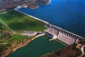
Hartwell Dam is a concrete and embankment dam located on the Savannah River at the border of South Carolina and Georgia, creating Lake Hartwell. The dam was built by the U.S. Army Corps of Engineers between 1955 and 1962 for the purposes of flood control, hydropower and navigation. The concrete and earthen structure spans 15,840 feet (4,828 m). The concrete section is 1,900 feet (579 m) long and rises 204 feet (62 m) above the riverbed at its apex. The Hartwell Dam currently produces 468 million KWh of electricity annually, has prevented over $40 million in flood damage since completion and also provides recreation, water quality, water supply, along with fish and wildlife management.

Mangrove Creek Dam, a concrete faced rockfill embankment dam, is the primary reservoir for water supply to residents of the Central Coast in New South Wales, Australia.

<span class="mw-page-title-main">Roller-compacted concrete</span>

Roller-compacted concrete (RCC) or rolled concrete (rollcrete) is a special blend of concrete that has essentially the same ingredients as conventional concrete but in different ratios, and increasingly with partial substitution of fly ash for Portland cement. The partial substitution of fly ash for Portland Cement is an important aspect of RCC dam construction because the heat generated by fly ash hydration is significantly less than the heat generated by Portland Cement hydration. This in turn reduces the thermal loads on the dam and reduces the potential for thermal cracking to occur. RCC is a mix of cement/fly ash, water, sand, aggregate and common additives, but contains much less water. The produced mix is drier and essentially has no slump. RCC is placed in a manner similar to paving; the material is delivered by dump trucks or conveyors, spread by small bulldozers or specially modified asphalt pavers, and then compacted by vibratory rollers.

<span class="mw-page-title-main">Canning Dam</span> Dam in Roleystone, Western Australia

The Canning Dam and reservoir are a major source of fresh water for the city of Perth, Western Australia. The dam is situated on the Darling Scarp and is an impoundment of the Canning River. It is noted for its innovative structural and hydraulic design that was considered to be at the forefront of concrete gravity dam design at the time of construction in from 1933 to its completion 1940.

<span class="mw-page-title-main">Embankment dam</span> Type of artificial dam

An embankment dam is a large artificial dam. It is typically created by the placement and compaction of a complex semi-plastic mound of various compositions of soil or rock. It has a semi-pervious waterproof natural covering for its surface and a dense, impervious core. This makes the dam impervious to surface or seepage erosion. Such a dam is composed of fragmented independent material particles. The friction and interaction of particles binds the particles together into a stable mass rather than by the use of a cementing substance.

<span class="mw-page-title-main">Alum Creek Lake</span>

Alum Creek Lake is a man-made reservoir located in Delaware County, Ohio, United States. It was built in 1974, covers 5 square miles (13 km2), and has a maximum capacity of 134,815 acre-feet (166,292,000 m3).

<span class="mw-page-title-main">Mosul Dam</span> Dam in Iraq

Mosul Dam, formerly known as Saddam Dam, is the largest dam in Iraq. It is located on the Tigris river in the western governorate of Nineveh, upstream of the city of Mosul. The dam serves to generate hydroelectricity and provide water for downstream irrigation. At full capacity, the structure holds about 11.1 cubic kilometres (2.7 cu mi) of water and provides electricity to the 1.7 million residents of Mosul.

<span class="mw-page-title-main">Fontenelle Dam</span> Dam on the Green River in Wyoming

Fontenelle Dam was built between 1961 and 1964 on the Green River in southwestern Wyoming. The 139-foot (42 m) high zoned earthfill dam impounds the 345,360-acre-foot (0.42600 km3) Fontenelle Reservoir. The dam and reservoir are the central features of the Seedskadee Project of the U.S. Bureau of Reclamation, which manages the Fontenelle impoundment primarily as a storage reservoir for the Colorado River Storage Project. The dam suffered a significant failure in 1965, when the dam's right abutment developed a leak. Emergency releases from the dam flooded downstream properties, but repairs to the dam were successful. However, in 1983 the dam was rated "poor" under Safety Evaluation of Existing Dams (SEED) criteria, due to continuing seepage, leading to an emergency drawdown. A concrete diaphragm wall was built through the core of the dam to stop leakage.

<span class="mw-page-title-main">John Redmond Reservoir</span> Reservoir in Coffey County, Kansas

John Redmond Reservoir is a reservoir on the Neosho River in eastern Kansas. Built and managed by the U.S. Army Corps of Engineers, it is used for flood control, recreation, water supply, and wildlife management. It borders the Flint Hills National Wildlife Refuge to the northwest.

<span class="mw-page-title-main">Portugués Dam</span> Dam in Tibes, Ponce, Puerto Rico

The Portugués Dam is a roller-compacted concrete thick arch dam on the Portugués River, three miles (5 km) northwest of the city Ponce, in Barrio Tibes, Ponce, Puerto Rico. Construction on the dam began in April 2008, soon after the U.S. Army Corps of Engineers, Jacksonville District awarded the Spanish firm Dragados USA, a division of Grupo ACS, with a $180 million contract in March 2008 to build the dam.

<span class="mw-page-title-main">Pressure grouting</span>

Pressure grouting or jet grouting involves injecting a grout material into otherwise inaccessible but interconnected pore or void space of which neither the configuration or volume are known, and is often referred to simply as grouting. The grout may be a cementitious, resinous, or solution chemical mixture. The greatest use of pressure grouting is to improve geomaterials. The purpose of grouting can be either to strengthen a formation or to reduce water flow through it. It is also used to correct faults in concrete and masonry structures. Since first usage in the 19th century, grouting has been performed on the foundation of virtually every one of the world's large dams, in order to reduce the amount of leakage through the rock, and sometimes to strengthen the foundation to support the weight of the overlying structure, be it of concrete, earth, or rock fill. It is also a key procedure in the creation of post-tensioned prestressed concrete, a material used in many concrete bridge designs, among other places.

San Antonio Dam is an embankment flood control and debris dam on San Antonio Creek in San Bernardino County, California, about 5 miles (8.0 km) north of Ontario. The dam was authorized by the Flood Control Acts of 1936 and 1938 as part of a major program to provide flood protection in the Santa Ana River system. Construction began in April 1952 and finished in May 1956. The dam controls runoff from a rugged catchment area of 27 square miles (70 km2) in the San Gabriel Mountains.

References

  1. 1 2 3 4 5 6 "Wolf Creek Dam". National Performance of Dams Program, National Inventory of Dams. Stanford University. Retrieved 2012-10-10.
  2. "Generation – Southeastern Power Administration". Energy.gov. Retrieved 2023-03-20.
  3. "Wolf Creek Dam USACE Brochure" (PDF). Retrieved 13 September 2023.
  4. "Corps of Engineers says releasing water from Tenn. dam prevented more damage to Nashville". Fox News . May 11, 2010. Retrieved 15 September 2013.
  5. "Wolf Creek Dam spills for first time in 12 years". United States Army Corps of Engineers. 16 March 2015. Retrieved 25 April 2019.
  6. 1 2 "International Water Power". www.waterpowermagazine.com. Retrieved 13 September 2023.
  7. 1 2 3 4 Seepage Problem, Wolf Creek Dam U.S. Army Corps of Engineers. Accessed 27 January 2007.
  8. Q's & A's, Wolf Creek Dam U.S. Army Corps of Engineers. Accessed 27 January 2007.
  9. 1 2 3 4 Project Manager's Assessment, Wolf Creek Dam U.S. Army Corps of Engineers. Accessed 27 January 2007.
  10. Bradley, Jeff, et al. (11 April 2007) Wolf Creek Dam Consensus Report: Engineering Risk and Reliability Analysis U.S. Army Corps of Engineers. Accessed 21 October 2007.
  11. (20 October 2007) Wolf Creek Dam Issues Prompt Siren Installation WTVF. Nashville, TN. Accessed 20 October 2007.
  12. (20 October 2007) New Warning System for Several Counties Near Wolf Creek Dam WKBO. Bowling Green, KY. Accessed 20 October 2007.
  13. Mapsky.gov Archived 2010-11-24 at the Wayback Machine
  14. "Nashville District > Missions > Current Projects > Construction > Wolf Creek Dam Safety Rehabilitation Project". Archived from the original on 2018-02-11. Retrieved 2018-02-11.