The West End is a neighbourhood in Vancouver, British Columbia, Canada, located between the Coal Harbour neighbourhood and the financial and central business districts of Downtown Vancouver to the east, Stanley Park to the northwest, the English Bay to the west, and Kitsilano to the southwest across the False Creek opening.

Waterfront station is a major intermodal public transportation facility and the main transit terminus in Vancouver, British Columbia, Canada. It is located on West Cordova Street in Downtown Vancouver, between Granville and Seymour Street. The station is also accessible via two other street-level entrances, one on Howe Street to the west for direct access to the Expo Line and another on Granville Street to the south for direct access to the Canada Line.

Cambie Street is a street in Vancouver, British Columbia, Canada. It is named for Henry John Cambie, chief surveyor of the Canadian Pacific Railway's western division.

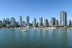
False Creek is a short narrow inlet in the heart of Vancouver, separating the Downtown and West End neighbourhoods from the rest of the city. It is one of the four main bodies of water bordering Vancouver, along with English Bay, Burrard Inlet, and the Fraser River. Granville Island is located within the inlet.

Downtown Vancouver is the central business district and the city centre neighbourhood of Vancouver, Canada, on the northwestern shore of the Burrard Peninsula in the Lower Mainland region of British Columbia. It occupies most of the north shore of the False Creek inlet, which cuts into the Burrard Peninsula creating the Downtown Peninsula, where the West End neighbourhood and Stanley Park are also located.

The history of Vancouver, British Columbia, is one that extends back thousands of years, with its first inhabitants arriving in the area following the Last Glacial Period. With its location on the western coast of Canada near the mouth of the Fraser River and on the waterways of the Strait of Georgia, Howe Sound, Burrard Inlet, and their tributaries, Vancouver has – for thousands of years – been a place of meeting, trade, and settlement.

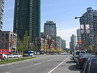
Yaletown–Roundhouse is an underground station on the Canada Line of Metro Vancouver's SkyTrain rapid transit system. The station is located on Davie Street at Mainland Street, approximately 80 metres (260 ft) northwest of Pacific Boulevard, and serves the residential and retail areas of Yaletown and Downtown Vancouver in Vancouver, British Columbia, Canada.

Lambton is a neighbourhood in the city of Toronto, Ontario, Canada. It is situated on the east bank of the Humber River north and south of Dundas Street West. It is bounded on the north by Black Creek, on the east by Jane Street and on the south by St. Mark's Road. The area west of Gooch Avenue and south of Dundas Street West is also known as "Warren Park", the name of the housing sub-division built in the 1950s. The portion south of Dundas Street West is within the 'Lambton Baby Point' neighbourhood as defined by the City of Toronto.
Main Street is a major north–south thoroughfare bisecting Vancouver, British Columbia, Canada. It runs from Waterfront Road by Burrard Inlet in the north, to Kent Avenue alongside the north arm of the Fraser River in the south.

Central Industrial is a light industrial area in Saskatoon, Saskatchewan, Canada, that comprises educational, recreational facilities, hotels and businesses along Idylwyld Drive. The community meets up with the Central Business District CBD to the west and south, and residential areas east and north.
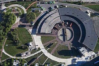
Roundhouse Park is a 17 acre park in the downtown core of Toronto, Ontario, Canada. It is in the former Railway Lands. It features the John Street Roundhouse, a preserved locomotive roundhouse which is home to the Toronto Railway Museum, Steam Whistle Brewing, and the restaurant and entertainment complex The Rec Room. The park is also home to a collection of trains, the former Canadian Pacific Railway Don Station, and the Roundhouse Park Miniature Railway. The park is bounded by Bremner Boulevard, Lower Simcoe Street, Lake Shore Boulevard West/Gardiner Expressway and Rees Street.

Sutherland Industrial is an industrial subdivision located in east-central Saskatoon, Saskatchewan, Canada. It was originally part of Sutherland, a town outside of Saskatoon before being annexed by the city in 1956. The subdivision also contains the first urban reserve in Saskatchewan, the Muskeg Lake Cree Nation.

Engine No. 374 is the Canadian Pacific Railway (CPR) locomotive that pulled the first transcontinental passenger train to arrive in Vancouver, arriving on May 23, 1887. This was a year after sister Engine No. 371 brought the first train to cross Canada into Port Moody, roughly 20 miles (32 km) to the east.

Throughout its history, Toronto has been a city divided into many districts and neighbourhoods. As the city has grown, new neighbourhoods have been created by expansion of the city into the countryside. Over time, the neighbourhoods within existing areas have also been altered and rearranged.

Railway Lands is an area in Downtown Toronto, Ontario, Canada. Originally a large railway switching yard near the Toronto waterfront, including the CNR Spadina Roundhouse and the CPR John Roundhouse, it has since been redeveloped and today is home to mostly mixed-used development, including the CN Tower and the Rogers Centre. The lands were owned and maintained by the Canadian National Railway and later transferred to the federal crown corporation Canada Lands Company. The area is bounded by Front Street, Yonge Street, Gardiner Expressway and Bathurst Street. The western portion of the Railway Lands is now part of the CityPlace neighbourhood and the eastern portion is now called South Core.
The gentrification of Vancouver, Canada, has been the subject of debate between those who wish to promote gentrification and those who do not.

The architecture of Vancouver and the Greater Vancouver area consists of a variety of modern architectural styles, such as the 20th-century Edwardian style and the 21st-century modernist style. Initially, the city architects embraced styles and ideas developed in Europe and the United States, with only limited local variation.
The Vancouver Greenway Network is a collection of greenways across Vancouver, British Columbia, Canada. Greenways are streets where pedestrians and cyclists are prioritized over motorized vehicles, through structures such as road closures and road diverters to prevent or limit motor vehicle traffic, widened sidewalk-promenades, narrowed road space, speed restrictions, bike lanes, raised sidewalks and speed bumps. The City of Vancouver hopes to create and maintain the trend of constructing new greenways to establish a network where, potentially, every citizen could access a city greenway within a 25-minute walking or a 10-minute cycling distance of their home.

The Kitsilano Trestle was a former railway bridge over False Creek, in Vancouver, British Columbia, Canada.