Robson Street

Last updated
Robson Street
Robsonstrasse
Robson Street night view 2012.jpg
Robson Street at night (2012)
Namesake John Robson
TypeStreet
Length2.5 km [1] (1.6 mi)
Location Downtown
Nearest metro station Vancouver City Centre Station
NW endChilco Street
Major
junctions
Burrard Street
Howe Street
Granville Street
Seymour Street
SE endBeatty Street
Other
Known forShopping district, Robson Square
Robson Street view from Hornby Street Robson Street Vancouver 201807.jpg
Robson Street view from Hornby Street

Robson Street is a major southeast-northwest thoroughfare in downtown and West End of Vancouver, British Columbia, Canada. Its core commercial blocks from Burrard Street to Jervis were also known as Robsonstrasse. [2] Its name honours John Robson, a major figure in British Columbia's entry into the Canadian Confederation, and Premier of the province from 1889 to 1892. Robson Street starts at BC Place Stadium near the north shore of False Creek, then runs northwest past Vancouver Library Square, Robson Square and the Vancouver Art Gallery, coming to an end at Lost Lagoon in Stanley Park.

Contents

As of 2006,[ needs update ] the city of Vancouver overall had the fifth most expensive retail rental rates in the world, averaging US$135 per square foot per year, citywide. Robson Street tops Vancouver with its most expensive locations renting for up to US$200 per square foot per year. [3] In 2006, both Robson Street and the Mink Mile on Bloor Street in Toronto were the 22nd most expensive streets in the world, with rents of $208 per square feet. In 2007, the Mink Mile and Robson slipped to 25th in the world with an average of $198 per square feet. The price of each continues to grow with Vancouver being Burberry's first Canadian location and Toronto's Yorkville neighbourhood (which is bounded on the south side by Bloor) now commanding rents of $300 per square foot.

In 1895, train tracks were laid down the street, supporting a concentration of shops and restaurants. From the early to middle-late 20th century, and especially after significant immigration from postwar Germany, the northwest end of Robson Street was known as a centre of German culture and commerce in Vancouver, earning the nickname Robsonstrasse, even among non-Germans (this name lives on in the Robsonstrasse Hotel on the street). At one time, the city had placed streetsigns reading "Robsonstrasse" though these were placed after the German presence in the area had largely vanished.

Robson Street was featured on an old edition of the Canadian Monopoly board as one of the two most expensive properties.

Upscale shopping

Robson Street's role as a consumer district continues to the present day although the original flavour of the street, which was all small neighbourhood-market stores, has been supplanted by massive redevelopment by brand-name chain stores and high-end restaurants. Robson Street is particularly famous for the fashion shops and dining which extends from Granville Street in the southeast to Denman Street in the northwest, with the main concentration centred between Burrard and Bute Streets, which is the area also known historically as Robsonstrasse.

Although not technically on Robson Street but still considered part of the district, the 'Vancouver Luxury Zone' contain the most expensive upscale stores in the city. It is anchored on Alberni Street and Georgia Streets as they intersect Burrard Street .

Robson and Thurlow

Robson street's intersection with Thurlow Street was known for having two Starbucks coffee shops on opposite corners, one of which was non-smoking prior to the enactment of the indoor smoking ban, and the other not. The location on the west corner is known as a major meeting place for the biker culture, with motorcycles parked in a special bikes-only strip of parking painted on the pavement. It was also this corner of Robson and Thurlow that acted as the epicentre of the Stanley Cup Riot of 1994. [4]

Neighbourhoods

Manhattan Apartments (1908) Vancouver Manhattan Apts 2010.jpg
Manhattan Apartments (1908)

There are numerous highrises along or near Robson, many of them condo towers and hotels. The Empire Landmark Hotel, originally the Sheraton Landmark, was the tallest highrise on the strip at 42 storeys. It included the Cloud Nine revolving restaurant.

There are numerous residential condo and apartment towers under construction along the southeastern end of Robson near Yaletown past the bustling Granville Mall, whereas the northwestern end becomes part of Vancouver's West End neighbourhood containing older residential highrises near the quieter Stanley Park and Lost Lagoon; the last few blocks of Robson between Denman and Lost Lagoon are part of the Stanley Park Neighbourhood.

Robson Street is also popular as a cruising street, with many exotic, rare cars and motorcycles present every weekend throughout the summer.

Major intersections

The entire route is in Vancouver.

km [1] miDestinationsNotes
0.00.0Lagoon Drive
Chilco Street
Continues west as Lagoon Drive into Stanley Park
0.30.19Denman Street
1.40.87Thurlow StreetOne-way, southwest bound
1.60.99 Burrard Street
1.71.1Hornby StreetOne-way, northeast bound
1.7–
1.8
1.1–
1.1
Robson Square (no vehicle access)
1.81.1BC-99.svg Howe Street (Hwy 99 south)One-way, southwest bound
1.91.2 Granville Street Granville Mall (transit only)
2.01.2BC-99.svg Seymour Street (Hwy 99 north)One-way, northeast-bound
2.41.5 Cambie Street
2.51.6Beatty StreetAcross from BC Place
1.000 mi = 1.609 km; 1.000 km = 0.621 mi
  •       Closed/former
  •       HOV only

See also

Related Research Articles

Gastown Neighbourhood in Vancouver, British Columbia, Canada

Gastown, the original settlement that became the core of the city of Vancouver, British Columbia, Canada, is a national historic site and a neighbourhood in the northwest section of the Downtown Eastside, adjacent to Downtown Vancouver.

West End, Vancouver Neighbourhood of Vancouver in British Columbia, Canada

The West End is a neighbourhood in Vancouver, British Columbia, Canada, located between the Coal Harbour neighbourhood and the financial and central business districts of Downtown Vancouver to the east, Stanley Park to the northwest, the English Bay to the west, and Kitsilano to the southwest across the False Creek opening.

Yorkville, Toronto Neighbourhood in Toronto, Ontario, Canada

Yorkville is a neighbourhood and former village in Toronto, Ontario, Canada. It is roughly bounded by Bloor Street to the south, Davenport Road to the north, Yonge Street to the east and Avenue Road to the west, and it is considered part of "The Annex" neighbourhood officially. Established as a separate community in 1830, it was annexed into Toronto in 1883. Yorkville is diverse and comprises residential areas, office space, and an array of shopping options.

Kitsilano Neighbourhood of Vancouver in British Columbia, Canada

Kitsilano is a neighbourhood located in the city of Vancouver, British Columbia, Canada. Kitsilano is named after Squamish Chief August Jack Khatsahlano, and the neighbourhood is located in Vancouver's West Side along the south shore of English Bay, between the neighbourhoods of West Point Grey and Fairview.

False Creek Inlet in Vancouver, British Columbia, Canada

False Creek is a short narrow inlet in the heart of Vancouver, separating the Downtown and West End neighbourhoods from the rest of the city. It is one of the four main bodies of water bordering Vancouver, along with English Bay, Burrard Inlet and the Fraser River. Granville Island is located within the inlet.

Bloor Street Major thoroughfare in Toronto

Bloor Street is a major east–west residential and commercial thoroughfare in Toronto, Ontario, Canada. Bloor Street runs from the Prince Edward Viaduct, which spans the Don River Valley, westward into Mississauga where it ends at Central Parkway. East of the viaduct, Danforth Avenue continues along the same right-of-way. The street, approximately 25 kilometres (16 mi) long, contains a significant cross-sample of Toronto's ethnic communities. It is also home to Toronto's famous shopping street, the Mink Mile.

Burrard station Metro Vancouver SkyTrain station

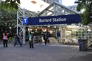
Burrard is an underground station on the Expo Line of Metro Vancouver's SkyTrain rapid transit system. The station is located in Downtown Vancouver on Burrard Street, where Melville and Dunsmuir Streets meet, and is the western terminus of the R5 Hastings St that provides service to Simon Fraser University.

Coal Harbour Neighbourhood in Vancouver, British Columbia, Canada

Coal Harbour is the name for a section of Burrard Inlet lying between Vancouver's Downtown Peninsula and the Brockton Point of Stanley Park. It has also now become the name of the neighbourhood adjacent to its southern shoreline.

Granville Street Street in Vancouver, British Columbia

Granville Street is a major street in Vancouver, British Columbia, Canada, and part of Highway 99. Granville Street is most often associated with the Granville Entertainment District and the Granville Mall. This street also cuts through residential neighbourhoods like Shaughnessy and Marpole via the Granville Street Bridge.

98 B-Line Former express bus service in Metro Vancouver, Canada

The 98 B-Line was a bus rapid transit line in Metro Vancouver, British Columbia, Canada. It linked Richmond to Downtown Vancouver, with a connection to Vancouver International Airport. It travelled mainly along Granville Street in Vancouver and a dedicated bus lane on No. 3 Road in Richmond. It was operated by Coast Mountain Bus Company and was funded by TransLink. The route was 16 kilometres (9.9 mi) long. The line carried over 18,000 passengers daily. It was discontinued on September 7, 2009, two and a half weeks after the opening of the Canada Line, which replaced it.

Downtown Vancouver Neighbourhood of Vancouver in British Columbia, Canada

Downtown Vancouver is the main central business district and the city center neighbourhood of Metro Vancouver, located on the northwestern shore of the Burrard Peninsula in the Lower Mainland region of British Columbia. The Downtown occupies most of the north shore of the False Creek inlet, which incises into the Burrard Peninsula creating the namesaked Downtown Peninsula, where the West End neighbourhood and Stanley Park are also located.

Transportation in Vancouver

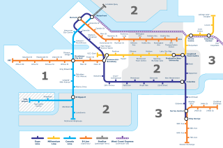
Transportation in Vancouver, British Columbia has many of the features of modern cities worldwide. Unlike many large metropolises, Vancouver has no freeways into or through the downtown area. A proposed freeway through the downtown was rejected in the 1960s by a coalition of citizens, community leaders and planners. This event "signalled the emergence of a new concept of the urban landscape" and has been a consistent element of the city's planning ever since.

History of Vancouver

The history of Vancouver is one that extends back thousands of years, with its first inhabitants arriving in the area following the Last Glacial Period. Vancouver is situated in British Columbia, Canada; with its location near the mouth of the Fraser River and on the waterways of the Strait of Georgia, Howe Sound, Burrard Inlet, and their tributaries. Vancouver has, for thousands of years, been a place of meeting, trade, and settlement.

Downtown Toronto Central business district in Toronto, Ontario, Canada

Downtown Toronto is the main central business district of Toronto, Ontario, Canada. Located entirely within the district of Old Toronto, it is approximately 17 square kilometres in area, bounded by Bloor Street to the northeast and Dupont Street to the northwest, Lake Ontario to the south, the Don Valley to the east, and Bathurst Street to the west. It is also the home of the municipal government of Toronto and the Government of Ontario.

Georgia Street

Georgia Street is an east–west street in the cities of Vancouver and Burnaby, British Columbia, Canada. Its section in Downtown Vancouver, designated West Georgia Street, serves as one of the primary streets for the financial and central business districts, and is the major transportation corridor connecting downtown Vancouver with the North Shore by way of the Lions Gate Bridge. The remainder of the street, known as East Georgia Street between Main Street and Boundary Road and simply Georgia Street within Burnaby, is more residential in character, and is discontinuous at several points.

Main Street (Vancouver) Major road in Vancouver, British Columbia

Main Street is a major north–south thoroughfare bisecting Vancouver, British Columbia, Canada. It runs from Waterfront Road by Burrard Inlet in the north, to Kent Avenue alongside the north arm of the Fraser River in the south.

750 Burrard Street

750 Burrard Street is a building in Downtown Vancouver, British Columbia, Canada, at the northeast corner of Robson Street and Burrard Street.

Mink Mile upscale fashion district in Toronto

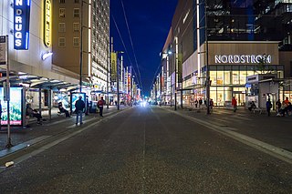
Mink Mile is an upscale shopping district in the neighbourhood of Yorkville in Toronto, Ontario, Canada, along Bloor Street between Yonge Street and Avenue Road.

Architecture of Vancouver

The architecture of Vancouver and the Metro Vancouver area holds a combination of modern architectural styles, ranging from the 20th century Edwardian style, to the 21st century modernist style and beyond. Initially, the city's architects embraced styles and ideas developed in Europe and the United States with only limited local variation.

References

  1. 1 2 Google (September 1, 2021). "Georgia Street" (Map). Google Maps . Google. Retrieved September 1, 2021.
  2. https://www.robsonstreet.ca/our-story/
  3. "Vancouver's retail rates among world's top five". Vancouver Sun. 2006-02-06. Retrieved 2008-07-10.
  4. "4 Canadian sports riots - Macleans.ca - Culture - Books".

Route map:

KML file (edithelp)
    KML is from Wikidata