University Endowment Lands

Last updated

University Endowment Lands
Unincorporated area
UEL in Metro Vancouver.svg
Location of the University Endowment Lands in Metro Vancouver.
CountryCanada
Province British Columbia
Regional district Metro Vancouver
Electoral Area Electoral Area A
Government
   MP Joyce Murray
   MLA David Eby
Area
[1]
  Total14.13 km2 (5.46 sq mi)
Elevation
80 m (260 ft)
Population
 (2021)
  Total3,193
  Density225.97/km2 (585.3/sq mi)
Time zone UTC-8 (PST)
  Summer (DST) UTC-7 (PDT)
Postal code span
V6S, V6T
Area code(s) 604, 778
Website University Endowment Lands

The University Endowment Lands (UEL) is an unincorporated area that lies to the west of the city of Vancouver, British Columbia, Canada, and adjacent to the University of British Columbia (UBC) and the lands associated with that campus. Pacific Spirit Regional Park lies within the UEL. The UEL is part of Metro Vancouver. Mail sent to the UEL is addressed to "Vancouver" rather than the UEL.

Contents

The UEL is administered directly by the province and landowners pay their property taxes directly to the provincial government. In a 1995 referendum, UEL residents voted against establishing a municipal governing body. [2]

Geography

The University Endowment Lands are located immediately west of the City of Vancouver. Statistics Canada reports a total land area of 14.13 square kilometres (5.46 sq mi). About half of the UEL is made up of Pacific Spirit Regional Park, a mostly forested land that was originally set aside for development which never materialized. Located on Point Grey, the UEL also boasts tall cliffs near the water, with steep drops of approximately 70 metres (230 ft) down to the beaches below.

Because of its isolated location and the nature of the steep cliffs next to the beaches, Greater Vancouver's only nude beaches are located in the University Endowment Lands, the best known being Wreck Beach, located near the western tip of the peninsula.

Climate

An aerial view of the University Endowment Lands, including UBC and Pacific Spirit Park Ubccampus.jpg
An aerial view of the University Endowment Lands, including UBC and Pacific Spirit Park
A University Endowment Lands welcome sign on Northwest Marine Drive Uel-sign.jpg
A University Endowment Lands welcome sign on Northwest Marine Drive

Because the UEL is close to seaside cliffs and the Strait of Georgia, above-average winds are common. Most of the winds come from the Strait itself, Howe Sound and English Bay.

Snowfalls are also more common than many parts of the City of Vancouver because of the area's higher altitude and the lack of an urban heat island due to less terrestrial development.

The UEL has higher humidity compared to other parts of Greater Vancouver because it is surrounded on three sides by water. Fog is common in the winter months, especially in areas near Pacific Spirit Park and the water.

Climate data for UBC, Vancouver
MonthJanFebMarAprMayJunJulAugSepOctNovDecYear
Record high °C (°F)16.4
(61.5)
17.9
(64.2)
19.5
(67.1)
25.0
(77.0)
31.0
(87.8)
30.0
(86.0)
31.1
(88.0)
32.8
(91.0)
30.0
(86.0)
25.0
(77.0)
17.5
(63.5)
14.6
(58.3)
32.8
(91.0)
Mean daily maximum °C (°F)6.0
(42.8)
7.6
(45.7)
9.5
(49.1)
12.3
(54.1)
15.7
(60.3)
18.0
(64.4)
20.4
(68.7)
20.5
(68.9)
17.9
(64.2)
13.1
(55.6)
8.5
(47.3)
6.1
(43.0)
13.0
(55.4)
Daily mean °C (°F)3.6
(38.5)
4.9
(40.8)
6.6
(43.9)
9.1
(48.4)
12.3
(54.1)
14.7
(58.5)
16.9
(62.4)
17.1
(62.8)
14.5
(58.1)
10.3
(50.5)
6.1
(43.0)
3.8
(38.8)
10.0
(50.0)
Mean daily minimum °C (°F)1.2
(34.2)
2.3
(36.1)
3.6
(38.5)
5.7
(42.3)
8.8
(47.8)
11.4
(52.5)
13.2
(55.8)
13.5
(56.3)
11.1
(52.0)
7.5
(45.5)
3.7
(38.7)
1.5
(34.7)
7.0
(44.6)
Record low °C (°F)−13.9
(7.0)
−12.5
(9.5)
−10.6
(12.9)
−0.6
(30.9)
1.7
(35.1)
2.6
(36.7)
7.3
(45.1)
6.1
(43.0)
0.6
(33.1)
−4.1
(24.6)
−12.5
(9.5)
−18.3
(−0.9)
−18.3
(−0.9)
Average precipitation mm (inches)162.7
(6.41)
137.5
(5.41)
121.9
(4.80)
89.6
(3.53)
68.3
(2.69)
55.5
(2.19)
39.3
(1.55)
48.1
(1.89)
58.6
(2.31)
113.6
(4.47)
198.9
(7.83)
183.5
(7.22)
1,277.4
(50.29)
Source: Environment Canada [3]

History

The territory was originally held by the Musqueam Indian Band which still lays claim to the area. [4]

The creation of the University Endowment Lands was first proposed after the passing of the University Endowment Act of 1907, in which the British Columbia provincial government agreed to set aside two million acres (8,000 km2) of British Columbia Crown land to be sold or leased to fund the creation of a university. This land was to be in the Cariboo region of the province's Interior, and consisted of mostly agricultural land. This idea was changed in 1911 when the provincial government passed the University Site Act, which set aside 175 acres (71 ha) in Point Grey for the university. This is where the UEL is located today.

"The Gates" monument at University Boulevard and Blanca Street, the intersection that straddles the border between Vancouver and the UEL UEL-thegates.jpg
"The Gates" monument at University Boulevard and Blanca Street, the intersection that straddles the border between Vancouver and the UEL

By 1920, it was realized that the Cariboo land did not have a high enough market value to generate the income needed for the university, so that idea was abandoned. This led to the British Columbia University Loan Act, which allowed the Lieutenant-Governor to sell 3,000 acres (12 km2) of Crown land on Point Grey for residential development. The money from the auction was put in the University Endowment Account for the university. [5]

However, a lot of the development that was planned was halted due to economic hardships stemming from the Great Depression. The university could not afford to prepare the land for development or to clear the forest land for development. In the 1930s, the university returned control of the land to the government. By the mid-1950s, over half of the undeveloped land in the UEL remained undeveloped due to the Depression and war shortages in the 1940s.

There have been many attempts to develop this land, which was then opposed by environmentally aware residents in the area. In 1988, the creation of Pacific Spirit Park was announced by the provincial Premier Bill Vander Zalm. The park currently makes up of over half of the UEL, acting as a greenbelt between the developed areas and the City of Vancouver. Development, in large part, is very limited; for any proposed developments in the UEL by the Greater Vancouver Regional District or the University of British Columbia, the following groups must be consulted beforehand: university students, university staff, university faculty, environmental groups, businesses, residents and the general public. [6]

Demographics

Street signs are commonly used to identify UBC's boundaries within the UEL. To the left is a regular UEL street sign, and to the right is UBC's street sign. Uel-streetsigns.jpg
Street signs are commonly used to identify UBC's boundaries within the UEL. To the left is a regular UEL street sign, and to the right is UBC's street sign.

In the 2021 census the University Endowment Lands had an official permanent population of 3,193. [7]

The University Endowment Lands' residential population is small and the non-university population includes mostly high-income professionals as the land there is very expensive. The other residents are mostly students living in the university's residences.

Government and politics

An unincorporated entity, the UEL has no mayor or municipal government. Rather, it is mostly governed by the University of British Columbia, the Metro Vancouver Regional District (MVRD) and the Province of British Columbia, and they control three entities: the University of British Columbia, University Hill and Pacific Spirit Regional Park. It is part of Electoral Area A of the GVRD.

Residential and commercial taxes are paid directly to the provincial government.

UEL residents are eligible to vote only for school board trustees in City of Vancouver municipal elections.

For provincial elections, the UEL falls under the Vancouver-Point Grey electoral riding. The current Member of the Legislative Assembly is David Eby.

For federal elections, the UEL is in the Vancouver Quadra electoral riding. The seat is held by Joyce Murray.

Neighbourhoods

The UEL is made up of four neighbourhood areas: [1]

Transportation

Pacific Spirit Regional Park, at the eastern end of the Endowment Lands, creates a physical buffer between the University and the adjacent Vancouver neighbourhoods of West Point Grey and Dunbar. Because of this, there are only five roads leading from Vancouver into the UEL: North West Marine Drive, 4th Avenue/Chancellor Boulevard, 10th Avenue/University Boulevard, 16th Avenue, and South West Marine Drive.

A typical bus for the 99 B-Line, one of the UEL's bus rapid transit services UBC Exchange (20190907 120610).jpg
A typical bus for the 99 B-Line, one of the UEL's bus rapid transit services

The UBC campus is a major destination for the regional public transit system operated by TransLink. The UBC Exchange is a major bus terminus that serves two of the busiest bus routes in the region: the 99 B-Line to Broadway and the R4 RapidBus to 41st Avenue; both routes link to the SkyTrain. [8] [9] An extension of the SkyTrain network to replace the 99 B-Line and connect the UBC campus is part of long-term plans from TransLink and the provincial government but remains unfunded. [10] [11] The U-Pass BC is a universal transit pass that is offered at a discount for students and faculty to offset commuting costs. [12]

Economy

The UEL is largely a residential neighbourhood, and most economic activity is centred at the University of British Columbia and the area around University Village and University Marketplace. UBC's stores are located mostly in the Student Union Building ("the SUB"). The Village and Marketplace, located next to each other near the intersection of University Boulevard and Allison Road, are located off-campus and home to a food court, several restaurants, some shops, some medical clinics and some services.

The University Village, as seen from University Boulevard University Village.jpg
The University Village, as seen from University Boulevard

The eastern end of the UEL is home to the University Golf Course, which is one of the original developments in the non-campus portions of the UEL.

Wreck Beach is also a popular area for locals and tourists alike due to its reputation as one of the largest clothing optional beaches in North America. A thriving market in food, drink, clothing, personal services and various recreational substances has prospered on the beach for decades.

Commercial centres

University Village

The University Village is the first commercial structure built on the UEL. Its main level mostly includes a convenience store, a McDonald's restaurant, a photocopying store and a florist.

The second level is home to a Japanese restaurant, a salon, a pizza parlour and a discount textbook store (which is in direct competition with UBC Bookstore, located on campus).

The University Marketplace, as seen from Western Parkway University Marketplace.jpg
The University Marketplace, as seen from Western Parkway

The basement level is entirely dedicated to a multicultural-themed food court, including Chinese, Japanese, Indian, Middle Eastern, etc.

University Marketplace

The University Marketplace [13] is a mixed commercial-residential structure completed around the late 1990s to the early 2000s. The main floor is home to Rogers Wireless, Staples Business Depot, Starbucks, several restaurants, some cafes and others.

The second floor of the Marketplace contains mostly offices and medical clinics. Some professors from UBC (especially those in the medical field) have offices located there, likely due to the proximity of the science buildings and UBC Hospital.

The upper floors of the Marketplace contain mostly residential apartment housing.

Education

The Vancouver School of Economics's Iona Building Vst-iona.jpg
The Vancouver School of Economics's Iona Building

The UEL is adjacent to the University of British Columbia (hence the name "University Endowment Lands"), the Vancouver School of Theology and Regent College.

In addition, the UEL is served by the Vancouver School Board and is zoned to University Hill Secondary School and University Hill Elementary School.

Emergency services and public safety

Surrounding municipalities

See also

Related Research Articles

<span class="mw-page-title-main">Richmond, British Columbia</span> City in British Columbia, Canada

Richmond is a city in the coastal Lower Mainland region of British Columbia, Canada. Mainly a suburban city, it occupies almost the entirety of Lulu Island, between the two estuarine distributaries of the Fraser River. Encompassing the adjacent Sea Island and several other smaller islands and uninhabited islets to its north and south, the suburb neighbours Vancouver and Burnaby on the Burrard Peninsula to the north, New Westminster and Annacis Island to the east, Delta to the south, and the Strait of Georgia to the west.

<span class="mw-page-title-main">University of British Columbia</span> Public university in Canada

The University of British Columbia (UBC) is a public research university with campuses near Vancouver and Okanagan in British Columbia, Canada. Established in 1908, it is the oldest university in British Columbia. With an annual research budget of $773 million, UBC funds over 10,000 projects a year.

<span class="mw-page-title-main">Pacific Spirit Regional Park</span> Park in the city of Vancouver, British Columbia

Pacific Spirit Regional Park is a 874 hectares park located in the University Endowment Lands, on Point Grey to the west of the city of Vancouver, British Columbia. It surrounds the endowment lands of the University of British Columbia on the shores of Georgia Strait in the Pacific Ocean. It is a nature preserve of the British Columbia government and classified under Electoral Area A.

<span class="mw-page-title-main">Wreck Beach</span> Beach in British Columbia, Canada

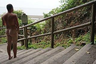
Wreck Beach is a clothing-optional beach located in Pacific Spirit Regional Park, which is in turn part of the University Endowment Lands just west of Vancouver, British Columbia, Canada. The clothing-optional section is clearly marked with signs and stretches approximately 6.7 kilometres or 4.2 miles from Acadia Beach, in the north, to the Booming Grounds Creek on the north arm of the Fraser River. The park is administered by the Greater Vancouver Regional District (GVRD), though Indigenous claims are repeatedly asserted, especially by the Musqueam Nation.

<span class="mw-page-title-main">Kitsilano</span> Neighbourhood of Vancouver in British Columbia, Canada

Kitsilano is a neighbourhood located in the city of Vancouver, British Columbia, Canada. Kitsilano is named after Squamish chief August Jack Khatsahlano, and the neighbourhood is located in Vancouver's West Side along the south shore of English Bay, between the neighbourhoods of West Point Grey and Fairview. The area is mostly residential with two main commercial areas, West 4th Avenue and West Broadway, known for their retail stores, restaurants and organic food markets.

<span class="mw-page-title-main">University Hill Secondary School</span> Secondary school in Vancouver, British Columbia, Canada

University Hill Secondary School is a public secondary school in the neighbourhood of Wesbrook Place in Point Grey Campus, just west of the University Endowment Lands and the city limits of Vancouver, British Columbia, Canada.

<span class="mw-page-title-main">Vancouver School Board</span> Public school district in British Columbia, Canada

The Vancouver School Board (VSB), officially the Board of Education of School District No. 39 (Vancouver), is a school district based in Vancouver, British Columbia, Canada. A board of nine elected trustees governs this school district that serves the city of Vancouver and the University Endowment Lands.

<span class="mw-page-title-main">Musqueam First Nation</span> First Nation in British Columbia, Canada

The Musqueam Nation is a First Nation whose traditional territory encompasses the western half of what is now Greater Vancouver, in British Columbia, Canada. It is governed by a band council and is known officially as the Musqueam Indian Band under the Indian Act. "Musqueam" is an anglicization of the Hunquminum name xʷməθkʷəy̓əm, which means "place of the river grass" or "place where the river grass grows".

<span class="mw-page-title-main">History of Vancouver</span>

The history of Vancouver, British Columbia, is one that extends back thousands of years, with its first inhabitants arriving in the area following the Last Glacial Period. With its location on the western coast of Canada near the mouth of the Fraser River and on the waterways of the Strait of Georgia, Howe Sound, Burrard Inlet, and their tributaries, Vancouver has – for thousands of years – been a place of meeting, trade, and settlement.

<span class="mw-page-title-main">West Point Grey</span> Neighbourhood in Metro Vancouver, British Columbia, Canada

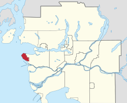
West Point Grey is a neighbourhood in the northwest of the city of Vancouver, British Columbia, Canada. It is on Point Grey and bordered by 16th Avenue to the south, Alma Street to the east, English Bay to the north, and Blanca Street to the west. Notable beaches within West Point Grey include Spanish Banks, Locarno and Jericho. Immediately to the south is Pacific Spirit Regional Park and to the east is Kitsilano.

<span class="mw-page-title-main">Vancouver Hospital and Health Sciences Centre</span> Hospital in British Columbia, Canada

Vancouver Hospital and Health Sciences Centre (VHHSC) is an acute care hospital affiliated with the University of British Columbia and located in Vancouver, British Columbia. The VHHSC is the second largest hospital in Canada, with 1,900 beds and nearly 116,000 patients each year. VHHSC employs 9500 staff and utilizes 1000 volunteers. As of 2005, the hospital's annual budget is $463 million. It is managed by Vancouver Coastal Health.

<span class="mw-page-title-main">Dunbar–Southlands</span> Neighbourhood in Lower Mainland, British Columbia, Canada

Dunbar–Southlands is a neighbourhood situated on the western side of Vancouver, British Columbia, Canada, that stretches north from the Fraser River and covers most of the land between the mouth of the Fraser and English Bay.

Point Grey is a headland marking the southern entrance to English Bay and Burrard Inlet in British Columbia, Canada. The headland is the site of Wreck Beach, Tower Beach, Point Grey Beach and most notably, since 1925, on its top is the Point Grey Campus of the University of British Columbia.

The University of British Columbia Okanagan is a satellite campus of the University of British Columbia in Kelowna, British Columbia, Canada.

<span class="mw-page-title-main">Corpus Christi College (Vancouver)</span> College in British Columbia, Canada

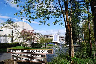
Corpus Christi College (CCC) is a college affiliated with and situated on the campus of University of British Columbia (UBC). The college offers classes in arts, business, and science in small class sizes with close student-faculty interaction.

<span class="mw-page-title-main">Higher education in British Columbia</span>

Higher education in British Columbia is delivered by 25 publicly funded institutions that are composed of eleven universities, eleven colleges, and three institutes. This is in addition to three private universities, five private colleges, and six theological colleges. There are also an extensive number of private career institutes and colleges. Over 297,000 students were enrolled in post-secondary institutions in British Columbia in the 2019-2020 academic year.

<span class="mw-page-title-main">University of British Columbia Vancouver</span> Main campus of the University of British Columbia

The University of British Columbia Vancouver is the main campus of the University of British Columbia, located on the Point Grey Peninsula in British Columbia, Canada.

Marine Drive is the name for three major roadways in Greater Vancouver, British Columbia, Canada. The roads are known for running parallel to major bodies of water, with some sections being a major arterial road, while other serve local traffic. Marine Way is the name applied to a section of Marine Drive that was bypassed in the early 1980s.

<span class="mw-page-title-main">Larry Grant (elder)</span> Musqueam and Chinese-Canadian elder

Elder Larry Grant is a Musqueam and Chinese-Canadian elder, educator, adjunct professor, mechanic, longshoreman, and cultural consultant.

References

  1. 1 2 "UNIVERSITY ENDOWMENT LANDS: Present & Past" (PDF). Ministry of Community, Sport and Cultural Development. Archived (PDF) from the original on May 22, 2018. Retrieved May 22, 2018.
  2. "University Endowment Lands". Greater Vancouver Book. Vancouver, BC: The Linkman Press. 1997. p. 109.
  3. "Canadian Climate Normals 1971–2000 – Vancouver Harbour CS". September 2011. Archived from the original on May 11, 2013. Retrieved February 4, 2013.
  4. "Home - Musqueam Indian Band". Musqueam. Archived from the original on September 3, 2023. Retrieved May 12, 2022.
  5. "University Endowment Lands Official Community Plan" (PDF). universityendowmentlands.gov.bc.ca. October 14, 2005. Archived (PDF) from the original on February 27, 2023. Retrieved May 28, 2024.
  6. "University Endowment Lands". Archived from the original on March 25, 2006. Retrieved March 2, 2006.
  7. Government of Canada, Statistics Canada (February 9, 2022). "Profile table, Census Profile, 2021 Census of Population - University Endowment Lands (UEL), Unincorporated place (UNP) [Designated place], British Columbia". www12.statcan.gc.ca. Archived from the original on February 9, 2022. Retrieved May 12, 2022.
  8. Chan, Kenneth (January 5, 2023). "TransLink cuts service on 99 B-Line: North America's busiest bus route". Daily Hive. Archived from the original on May 18, 2024. Retrieved May 17, 2024.
  9. Saltman, Jennifer (January 6, 2020). "TransLink launches new and revamped RapidBus routes". Vancouver Sun. Archived from the original on January 21, 2022. Retrieved May 17, 2024.
  10. Ip, Stephanie (April 20, 2018). "UBC willing to chip in for SkyTrain Millennium Line extension to reach Point Grey campus". Vancouver Sun. Archived from the original on March 29, 2022. Retrieved May 17, 2024.
  11. Chan, Kenneth (March 20, 2023). "Detailed technical design and planning set to begin for UBC SkyTrain extension project". Daily Hive. Archived from the original on May 18, 2024. Retrieved May 17, 2024.
  12. Saltman, Jennifer (August 26, 2020). "U-Pass returning for Metro Vancouver post-secondary students in September". Vancouver Sun. Archived from the original on January 24, 2022. Retrieved May 17, 2024.
  13. Vancouver's most luxurious rental condominiums Archived February 21, 2006, at the Wayback Machine . University MarketPlace. Retrieved on 2014-04-12.
  14. "Detachments in B.C." www.rcmp-grc.gc.ca. Archived from the original on March 3, 2007.
  15. "UBCH Urgent Care Centre - Vancouver - Hospitals - Health Facilities - VCH". www.vch.ca. Archived from the original on October 18, 2007.

49°15′29″N123°13′41″W / 49.258°N 123.228°W / 49.258; -123.228