Downtown Vancouver

Last updated
Downtown Vancouver
Neighbourhood of Vancouver
Vancouverdowntown2019.jpg
Skyscrapers of Vancouver's Financial District, taken from Harbour Centre tower
Vancouver Downtown.jpg
Location of Downtown Vancouver shown in red
Coordinates: 49°17′03″N123°07′16″W / 49.28417°N 123.12111°W / 49.28417; -123.12111
CountryCanada
Province British Columbia
City Vancouver
Communities
Area
[1]
  Total3.7 km2 (1.4 sq mi)
Population
  Total62,030 [2]
  Density16,764/km2 (43,420/sq mi)
Website vancouver.ca/news-calendar/downtown.aspx

Downtown Vancouver is the central business district and the city centre neighbourhood of Vancouver, Canada, on the northwestern shore of the Burrard Peninsula in the Lower Mainland region of British Columbia. It occupies most of the north shore of the False Creek inlet, which cuts into the Burrard Peninsula creating the Downtown Peninsula, where the West End neighbourhood and Stanley Park are also located.

Contents

Along with West End, Stanley Park and the nearby Downtown Eastside, Downtown makes up Central Vancouver, one of the city's three main areas (the others being East Side and West Side).

With a disproportionately high amount of residential towers for a central business district in a geographically constrained area, Downtown Vancouver is one of the densest areas in the country.[ citation needed ]

Geography

Downtown Vancouver is bounded by Burrard Inlet to the north. Downtownvancouverviewfromstanleypark.JPG
Downtown Vancouver is bounded by Burrard Inlet to the north.

The Downtown area is generally considered to be bounded by Burrard Inlet to the north, West End to the west, Granville Island/Fairview and Mount Pleasant across the False Creek to the south, and Downtown Eastside and Strathcona to the east and southeast. Most unofficial sources also include West End and Stanley Park into Downtown (the so-called "Downtown Peninsula"), but the City of Vancouver officially defines them as separate neighbourhoods.

Besides the readily identifiable office towers of the financial and central business districts, Downtown Vancouver also includes residential neighbourhoods in the form of high-rise apartments and condominiums in Yaletown and Coal Harbour, and other Downtown neighbourhoods include the Granville Mall and Entertainment District, Downtown South, Gastown, Chinatown and Japantown.

Notable sub-neighbourhoods

Demographics

Panethnic groups in the Downtown Vancouver neighbourhood (2001−2016)
Panethnic
group
2016 [3] 2006 [4] 2001 [5]
Pop. %Pop.%Pop.%
European [lower-alpha 1] 31,73024,66516,940
East Asian [lower-alpha 2] 13,2259,9056,720
Middle Eastern [lower-alpha 3] 4,4752,245640
South Asian 2,6101,130650
Southeast Asian [lower-alpha 4] 1,9801,245610
Indigenous 1,4301,3801,150
Latin American 1,585750495
African 655615310
Other/Multiracial [lower-alpha 5] 1,160650200
Total responses58,85542,58027,720
Total population62,03043,41527,990
Note: Totals greater than 100% due to multiple origin responses

Architecture

Sunset over Downtown Vancouver Vancouver sunset (J).jpg
Sunset over Downtown Vancouver

The downtown area includes most of the remaining historic buildings and many of the larger notable buildings in the region. All but one of Vancouver's tallest buildings are located within Downtown Vancouver, the one being Marine Gateway North located next to Marine Drive station.

Sports

There are two major sporting facilities in the downtown core, Rogers Arena (formerly GM Place) and BC Place Stadium. The NHL's Vancouver Canucks play at Rogers Arena, while the CFL's BC Lions and the MLS's Vancouver Whitecaps FC use the neighbouring BC Place Stadium. SkyTrain Stadium-Chinatown station provides easy rapid transit access to the district.

Transportation

Burrard Street Bridge is a major bridge and access point to Downtown. Burrard Bridge and False Creek Vancouver.jpg
Burrard Street Bridge is a major bridge and access point to Downtown.

The presence of water on three sides limits access to downtown Vancouver. There are four major bridges: the Lions Gate Bridge, connecting to the North Shore municipalities and the Trans Canada Highway, and the Burrard Street Bridge, Cambie Street Bridge, and Granville Street Bridge, which provide access to the commercial and residential areas south of False Creek.

The historic Waterfront station is the principal transit hub for the downtown core. There are six subway stations located in downtown Vancouver running on two SkyTrain lines: the Expo Line and Canada Line. The Expo Line travels from Waterfront station at the foot of the central harbor and through Dunsmuir Tunnel to the east. The Canada Line travels from Waterfront station and tunnels south under Granville Street and Davie Street, linking downtown to central Richmond and Vancouver International Airport. SeaBus is a passenger-only ferry that connects from Waterfront station to the North Shore in 10–12 minutes. The West Coast Express commuter rail system travels from Waterfront station to the eastern suburbs and exurbs. The West Coast Express travels from Waterfront to Moody Centre, Coquitlam Central, Port Coquitlam, Pitt Meadows, Maple Meadows Station, Port Haney and Mission City as its terminus station [6] Terminals are also available near Waterfront station for float planes and helicopters.

Waterfront station is a major intermodal public transportation hub in Downtown Vancouver. Waterfront Station 201807.jpg
Waterfront station is a major intermodal public transportation hub in Downtown Vancouver.

Most north-south Vancouver bus routes serve Downtown Vancouver, in addition to suburban routes from the North Shore and Burnaby. The bus rapid transit line 98 B-Line had eight stops in the downtown core, primarily along Seymour Street and Burrard Street. This service was replaced on August 17, 2009, by SkyTrain's Canada Line. The 95 B-Line started service in December 2016 in conjunction with the opening of the Evergreen Extension, connecting downtown to Simon Fraser University along Hastings Street.

There are two private passenger water taxi operators (False Creek Ferries and The Aquabus), providing service between several downtown neighbourhoods, False Creek, and Granville Island.

The city is planning to extend the downtown streetcar from its current route of Granville Island to the Main Street SkyTrain station, with future plans extending it to Chinatown and then to Stanley Park.

Notes

  1. Statistic includes all persons that did not make up part of a visible minority or an indigenous identity.
  2. Statistic includes total responses of "Chinese", "Korean", and "Japanese" under visible minority section on census.
  3. Statistic includes total responses of "West Asian" and "Arab" under visible minority section on census.
  4. Statistic includes total responses of "Filipino" and "Southeast Asian" under visible minority section on census.
  5. Statistic includes total responses of "Visible minority, n.i.e." and "Multiple visible minorities" under visible minority section on census.

Related Research Articles

<span class="mw-page-title-main">Gastown</span> Neighbourhood in Vancouver, Canada

Gastown is the original settlement that became the core of the city of Vancouver, British Columbia, Canada, and a national historic site and a neighbourhood in the northwest section of the Downtown Eastside, adjacent to Downtown Vancouver.

<span class="mw-page-title-main">West End, Vancouver</span> Neighbourhood in Vancouver, British Columbia, Canada

The West End is a neighbourhood in Vancouver, British Columbia, Canada, located between the Coal Harbour neighbourhood and the financial and central business districts of Downtown Vancouver to the east, Stanley Park to the northwest, the English Bay to the west, and Kitsilano to the southwest across the False Creek opening.

<span class="mw-page-title-main">Waterfront station (Vancouver)</span> Metro Vancouver public transportation facility

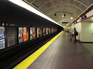
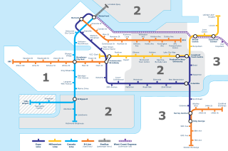
Waterfront station is a major intermodal public transportation facility and the main transit terminus in Vancouver, British Columbia, Canada. It is on West Cordova Street in Downtown Vancouver, between Granville and Seymour Street. The station is also accessible via two other street-level entrances, one on Howe Street to the west for direct access to the Expo Line and another on Granville Street to the south for direct access to the Canada Line.

<span class="mw-page-title-main">Kitsilano</span> Neighbourhood of Vancouver in British Columbia, Canada

Kitsilano is a neighbourhood located in the city of Vancouver, British Columbia, Canada. Kitsilano is named after Squamish chief August Jack Khatsahlano, and the neighbourhood is located in Vancouver's West Side along the south shore of English Bay, between the neighbourhoods of West Point Grey and Fairview. The area is mostly residential with two main commercial areas, West 4th Avenue and West Broadway, known for their retail stores, restaurants and organic food markets.

<span class="mw-page-title-main">False Creek</span> Inlet in Vancouver, British Columbia, Canada

False Creek is a short narrow inlet in the heart of Vancouver, separating the Downtown and West End neighbourhoods from the rest of the city. It is one of the four main bodies of water bordering Vancouver, along with English Bay, Burrard Inlet, and the Fraser River. Granville Island is located within the inlet.

<span class="mw-page-title-main">Yaletown</span> Place in British Columbia, Canada

Yaletown is an area of Downtown Vancouver, Canada, bordered by False Creek and Robson and Homer Streets. Formerly a heavy industrial area dominated by warehouses and rail yards, since the 1986 World's Fair it has been transformed into one of the most densely populated neighbourhoods in the city.

<span class="mw-page-title-main">Hastings–Sunrise</span> Neighbourhood of Vancouver in British Columbia, Canada

Hastings–Sunrise is a neighbourhood located in the northeastern corner of the city of Vancouver, British Columbia.

<span class="mw-page-title-main">Vancouver Downtown Historic Railway</span>

The Vancouver Downtown Historic Railway was a heritage electric railway line that operated from 1998 to 2011 between Granville Island and Science World, in Vancouver, British Columbia, Canada. It operated only on weekends and holidays, usually from May to mid-October, and was aimed primarily at tourists. Two restored interurban trams were used on the line, which used a former freight railway right-of-way.

<span class="mw-page-title-main">Strathcona, Vancouver</span> Neighbourhood in Vancouver, Metro Vancouver

Strathcona is the oldest residential neighbourhood of Vancouver, British Columbia, Canada. Officially a part of the East Side, it is bordered by Downtown Vancouver's Chinatown neighbourhood and the False Creek inlet to the west, Downtown Eastside to the north, Grandview-Woodland to the east, and Mount Pleasant to the south of Emily Carr University and the Canadian National Railway and Great Northern Railway classification yards.

<span class="mw-page-title-main">Dunsmuir Tunnel</span> Subway in Vancouver, BC

The Dunsmuir Tunnel is a subway tunnel below Dunsmuir Street in Vancouver, British Columbia, Canada. The tunnel is used by the Expo Line of Metro Vancouver's SkyTrain rapid transit system. It is located downtown and has Burrard and Granville stations built within the tunnel. The western tunnel portal is located midway between Waterfront and Burrard stations, while the eastern portal is adjacent to Stadium–Chinatown station.

<span class="mw-page-title-main">98 B-Line</span> Former express bus service in Metro Vancouver, Canada

The 98 B-Line was a bus rapid transit line in Metro Vancouver, British Columbia, Canada, that began service in September 2000. It linked Richmond to Downtown Vancouver, with a connection to Vancouver International Airport. It travelled mainly along Granville Street in Vancouver and a dedicated bus lane on No. 3 Road in Richmond. It was operated by Coast Mountain Bus Company and was funded by TransLink. The route was 16 kilometres (9.9 mi) long. The line carried over 18,000 passengers daily. It was discontinued in September 2009, shortly after the opening of the Canada Line, which replaced it.

<span class="mw-page-title-main">Transportation in Vancouver</span>

Transportation in Vancouver, British Columbia, has many of the features of modern cities worldwide. Unlike many large metropolises, Vancouver has no freeways into or through the downtown area. A proposed freeway through the downtown was rejected in the 1960s by a coalition of citizens, community leaders and planners. This event "signalled the emergence of a new concept of the urban landscape" and has been a consistent element of the city's planning ever since.

<span class="mw-page-title-main">Arbutus Ridge</span> Neighbourhood in British Columbia, Canada

Arbutus Ridge is an affluent residential neighbourhood in Vancouver's West Side. It is bordered by 16th Avenue in the north, 41st Avenue in the south, Mackenzie Street in the west, and East Boulevard in the east. The neighbourhood is characterized by larger than average lot sizes, with stately homes on tree-lined streets.

<span class="mw-page-title-main">Fairview, Vancouver</span> Place in British Columbia, Canada

Fairview is a neighbourhood on the west side of the city of Vancouver, British Columbia, Canada. It runs from False Creek in the north to 16th Avenue in the south, and from Burrard Street in the west to Cambie Street in the east.

<span class="mw-page-title-main">Grandview–Woodland</span> Neighbourhood in Lower Mainland, British Columbia, Canada

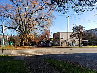
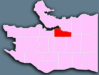
Grandview–Woodland, also commonly known as Grandview–Woodlands, is a neighbourhood in Vancouver, British Columbia, Canada to the east of the downtown area, stretching south from the shores of Burrard Inlet and encompassing portions of the popular Commercial Drive area. It is a mature neighbourhood in Vancouver that is a vibrant mixture of commercial, industrial, single-family and multi-family residential with a rich ethnic history and features.

<span class="mw-page-title-main">Mount Pleasant, Vancouver</span> Neighborhood of Vancouver, British Columbia, Canada

Mount Pleasant is a neighbourhood in the city of Vancouver, British Columbia, Canada, stretching from Cambie Street to Clark Drive and from Great Northern Way and 2nd, to 16th and Kingsway. The neighbourhood, once characterized as working-class, has undergone a process of gentrification since the early 1990s, including the area around the Main Street and Broadway intersection.

<span class="mw-page-title-main">Oakridge, Vancouver</span> Neighbourhood in Vancouver, British Columbia, Canada

Oakridge is a neighbourhood in Vancouver, British Columbia, Canada, with a multicultural residential and commercial area. It had a population of 13,030 in 2016, of which approximately 50 percent have Chinese as their mother tongue.

<span class="mw-page-title-main">Main Street (Vancouver)</span> Major road in Vancouver, British Columbia

Main Street is a major north–south thoroughfare bisecting Vancouver, British Columbia, Canada. It runs from Waterfront Road by Burrard Inlet in the north, to Kent Avenue alongside the north arm of the Fraser River in the south.

<span class="mw-page-title-main">Architecture of Vancouver</span>

The architecture of Vancouver and the Greater Vancouver area consists of a variety of modern architectural styles, such as the 20th-century Edwardian and the 21st-century modernist styles. Initially, the city architects embraced styles developed in Europe and the United States, with only limited local variation.

References

  1. Vancouver, Government of the City of. "Downtown" (PDF). Downtown census data - City of Vancouver. City of Vancouver.
  2. Vancouver, Government of the City of. "Downtown" (PDF). Downtown census data - City of Vancouver. City of Vancouver. Retrieved 12 March 2020.
  3. Open Data Portal, City Of Vancouver (2018-04-10). "Census local area profiles 2016". opendata.vancouver.ca. Retrieved 2023-03-19.
  4. Open Data Portal, City Of Vancouver (2013-03-25). "Census local area profiles 2006". opendata.vancouver.ca. Retrieved 2023-03-19.
  5. Open Data Portal, City Of Vancouver (2013-03-25). "Census local area profiles 2001". opendata.vancouver.ca. Retrieved 2023-03-19.
  6. "West Coast Express". new.translink.ca. Retrieved 2020-04-16.