British Columbia Highway 99A

Last updated

BC-99A.svg

Highway 99A

Route information
Auxiliary route of Hwy 99
Maintained by British Columbia Ministry of Transportation and Infrastructure
Location
Country Canada
Province British Columbia
Highway system
    BC-99.svg Hwy 99 BC-101.svg Hwy 101

    Highway 99A is a series of former highways in the southwestern part of British Columbia, Canada. It was the designation of the former 1942 alignment of Highway 99 as well a various alternate routes which existed in the 1950s and 1960s. The last official use of '99A' was decommissioned in 2006, although some present-day, commercially published road maps still show it and some remnant signage still remains. Some brand new 99A signs can be seen as well as of 2023.

    Contents

    King George Highway / Kingsway

    BC-99A.svg

    Highway 99A

    Location Surrey, New Westminster, Burnaby, Vancouver
    Length48 km [1]  (30 mi)
    Existed1973–2006

    Highway 99A was 48 km (30 mi) long highway within Greater Vancouver and followed the original Highway 99 alignment between the Peace Arch Border Crossing and Downtown Vancouver and was designated in 1973 when the Deas (Island) Throughway was renamed Highway 99. Prior to that, the four-lane, divided "Deas (Island) Throughway" which was completed to the U.S. border in 1962, was designated Highway 499. Highway 99A was decommissioned by the province in 2006 and the city of Surrey renamed "King George Highway" to "King George Boulevard" in 2009, [2] although, as of July 2021, the Ministry of Transportation keeps two minor segments of the former route maintained in its inventory. [3]

    Route description

    Pattullo Bridge, seen from the Skybridge. Pattullo-from-skyt.jpg
    Pattullo Bridge, seen from the Skybridge.

    Highway 99A started in Surrey at the first exit off Highway 99 north of the Peace Arch and followed the King George Highway. Originally to be named the Peace Arch Highway, it was dedicated officially on October 16, 1940 as the King George VI Highway after the royal visit of 1939. The highway served as a route for commuters travelling to New Westminster, Burnaby, and Vancouver. The highway goes north for 8 km (5 mi) to an interchange with Highway 99, and from there, another 4 km (2.5 mi) to its junction with Highway 10. The highway continued north for another 9 km (5.6 mi) to Fraser Highway, where it merged with Highway 1A. Highways 1A and 99A continued northwest for 6 km (3.7 mi) to the Pattullo Bridge over the Fraser River, crossing from Surrey into New Westminster.

    In New Westminster, Highway 99A followed McBride Boulevard and 10th Avenue, then onto Kingsway, where the highway entered Burnaby. Highway 99A then proceeded west-northwest for 6 km (3.7 mi) through the City of Burnaby to its intersection with Boundary Road, at which point the highway crossed into Vancouver. In Vancouver, Highway 99A continued on Kingsway northwest for 7 km (4.3 mi), then onto Main Street. Highway 99A followed Main Street north for 2 km (1.2 mi), then west onto the Dunsmuir Viaduct and Dunsmuir Street into the downtown core of the city to Burrard Street, where it reunited with Highway 99 on Georgia Street; southbound traffic followed Georgia Street to Main Street.

    Major intersections

    The entire route was in Metro Vancouver Regional District.

    Locationkm [1] miDestinationsNotes
    Surrey 0.00.0BC-99.svg Hwy 99  / 8 Avenue Vancouver, United States Border, Seattle, White Rock Hwy 99 exit 2; segment between 8 Ave and northbound entrance from Hwy 99 is still provincially maintained [3]
    8.05.0BC-99.svg Hwy 99  Vancouver, U.S.A. Border Hwy 99 exit 10; no access from northbound King George Blvd to southbound Hwy 99; segment from 121 m (397 ft) north of Crescent Road, across Nicomekl River Bridge to 40 Ave is still provincially maintained [3]
    10.26.3Colebrook RoadGrade separated
    12.0–
    12.2
    7.5–
    7.6
    BC-10.svg Hwy 10 (56 Avenue / 58 Avenue) Delta, Langley, Hope Split intersection
    20.812.9 Fraser Highway (Hwy 1A east)South end of former Hwy 1A concurrency
    25.916.1Scott RoadGrade separated
    Fraser River 26.0–
    27.2
    16.2–
    16.9
    Pattullo Bridge
    North end of King George Boulevard • South end of McBride Boulevard
    New Westminster 27.517.1Royal Avenue / Columbia StreetGrade separated
    Burnaby [lower-alpha 1]
    New Westminster [lower-alpha 2]
    29.418.310th AvenueFormer Hwy 1A / Hwy 99A follows 10th Avenue
    31.419.510th Avenue
    12th Street / Kingsway
    Former Hwy 1A / Hwy 99A followed Kingsway
    Vancouver 44.9–
    45.1
    27.9–
    28.0
    BC-7.svg Broadway (Hwy 7) / Main Street Former Hwy 1A / Hwy 99A followed Main Street
    46.528.9 Main Street
    Dunsmuir Street
    Former Hwy 1A west / Hwy 99A north followed Dunsmuir Street;
    former Hwy 1A east / Hwy 99A south followed Georgia Street
    46.5–
    47.4
    28.9–
    29.5
    Georgia and Dunsmuir Viaduct
    47.9–
    48.1
    29.8–
    29.9
    BC-99.svg Howe Street, Seymour Street (Hwy 99 south) Airport (YVR), U.S. Border, Seattle
    BC-99.svg Georgia Street (Hwy 99 north) / Hwy 1A west West Vancouver, Horseshoe Bay, Whistler
    One-way pair; Hwy 99A northern terminus
    1.000 mi = 1.609 km; 1.000 km = 0.621 mi
    Footnotes
    1. North of 10th Avenue
    2. South of 10th Avenue

    Pacific Highway

    BC-99A.svg

    Highway 99A

    Location Surrey
    Length25 km [1]  (16 mi)
    Existed1942–1958

    Between 1942 and 1962, the King George Highway was designated Highway 99, while the Highway 99A designation was given to the older Pacific Highway after it became the alternate U.S. border route. The highway began at the Pacific Highway Border Crossing near the locality of Douglas (now part of Surrey) and continued north to Cloverdale, where it shared the alignment with the Highway 1 (present-day Fraser Highway) to the King George Highway (Highway 99). [4] In 1958, the Pacific Highway was redesignated as Highway 15.

    Grandview Highway

    BC-99A.svg

    Highway 99A

    Location New Westminster, Burnaby, Vancouver
    Length15 km [1]  (9.3 mi)
    Existed1942–1962

    Between 1942 and 1962, the Grandview Highway was designated as Highway 99A, serving as an alternate route to Kingsway between Pattullo Bridge and Vancouver. From the bridge in New Westminster, Highway 99A followed McBride Boulevard and 8th Avenue to 8th Street (at the time, Highway 1/99 followed Columbia Street and 12th Street though downtown New Westminster to Kingsway). [5] After crossing 10th Avenue, Highway 99A entered into Burnaby and become Grandview Highway (sometimes referred to as the Douglas-Grandview Highway as it was known as Douglas Road prior to 1926). [6] At Boundary Road, Grandview Highway turned north for a few blocks before turning west and entering Vancouver, where it travelled in a west-northwest direction along Grandview Highway North to Clark Drive, where Highway 99A followed Clark Drive to the Grandview Viaduct and Terminal Avenue, rejoining Highway 1/99 at Main Street near the Pacific Central Station. [5]

    Highway 401 was constructed to the north of Grandview Highway and opened in 1964, replacing Highway 99A as a regional east-west highway, and the route was reverted to the respective local municipalities. In 1968, the Douglas-Grandview Highway was renamed Canada Way in honour of the Canadian Centennial which was a year earlier. [6] Vancouver also later prioritized Grandview Highway to follow Grandview Highway South and connect with 12th Avenue, while Grandview Highway North experienced a series of traffic calming measures, which includes carrying a portion of the SkyTrain's Expo Line and later conversion to a greenway and bikeway. [7]

    Related Research Articles

    <span class="mw-page-title-main">Burnaby</span> City in British Columbia, Canada

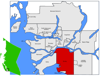
    Burnaby is a city in the Lower Mainland region of British Columbia, Canada. Located in the centre of the Burrard Peninsula, it neighbours the City of Vancouver to the west, the District of North Vancouver across the confluence of the Burrard Inlet with its Indian Arm to the north, Port Moody and Coquitlam to the east, New Westminster and Surrey across the Fraser River to the southeast, and Richmond on the Lulu Island to the southwest.

    <span class="mw-page-title-main">Expo Line (SkyTrain)</span> Rapid transit line in Metro Vancouver, Canada

    The Expo Line is the oldest line of the SkyTrain rapid transit system in the Metro Vancouver region of British Columbia, Canada. The line is owned and operated by BC Rapid Transit Company, a subsidiary of TransLink, and links the cities of Vancouver, Burnaby, New Westminster and Surrey.

    Highway 1 is a provincial highway in British Columbia, Canada, that carries the main route of the Trans-Canada Highway (TCH). The highway is 1,047 kilometres (651 mi) long and connects Vancouver Island, the Greater Vancouver region in the Lower Mainland, and the Interior. It is the westernmost portion of the main TCH to be numbered "Highway 1", which continues through Western Canada and extends to the Manitoba–Ontario boundary. The section of Highway 1 in the Lower Mainland is the second-busiest freeway in Canada, after Ontario Highway 401 in Toronto.

    Highway 17 is a provincial highway in British Columbia, Canada. It comprises two separate sections connected by a ferry link. The Vancouver Island section is known as the Patricia Bay Highway and connects Victoria to the Swartz Bay ferry terminal in North Saanich. The Lower Mainland section is known as the South Fraser Perimeter Road and connects the Tsawwassen ferry terminal to Delta and Surrey, terminating at an interchange with Highway 1 in the Fraser Valley.

    Highway 99 is a provincial highway in British Columbia that runs 377 kilometres (234 mi) from the U.S. border to near Cache Creek, serving Greater Vancouver and the Squamish–Lillooet corridor. It is a major north–south artery within Vancouver and connects the city to several suburbs as well as the U.S. border, where it continues south as Interstate 5. The central section of the route, also known as the Sea to Sky Highway, serves the communities of Squamish, Whistler, and Pemberton. Highway 99 continues through Lillooet and ends at a junction with Highway 97 near Cache Creek.

    Highway 7, known for most of its length as the Lougheed Highway and Broadway, is an alternative route to Highway 1 through the Lower Mainland region of British Columbia. Whereas the controlled-access Highway 1 follows the southern bank of the Fraser River, Highway 7 follows the northern bank.

    <span class="mw-page-title-main">British Columbia Highway 15</span> Highway in British Columbia

    Highway 15 (BC 15), known locally as the Pacific Highway, is a 20.99-kilometre-long (13.04 mi) north–south highway primarily located in the City of Surrey, British Columbia. The southern terminus is with Interstate 5 (I-5) near Blaine, Washington, as State Route 543 (SR 543). SR 543 is a 1.75-kilometre-long (1.09 mi) connector between I-5 and the Canada–US border, linking with BC 15. Over 3,000 trucks per day pass through the border crossing along SR 543 and BC 15, because the Peace Arch border crossing does not allow commercial trucks.

    There are many roads in the southwestern part of British Columbia and Vancouver Island that were designated as Highway 1A. These roads were sections of the original 1941 route of Highway 1 before its various re-alignments, and are used today as service routes and frontage roads. The "B.C. Highway 1A" designations were removed from these sections by the province between 2005 and 2010, although signage remains along some of the route and the designation on some maps.

    Highway 7A, known locally and on street signs as the Barnet Highway, Barnet Road,St. Johns Street, Inlet Drive and Hastings Street, was Highway 7's original 1941 route between the harbour in Vancouver and Port Moody. The highway gained the 7A designation around 1953 due to Highway 7 being re-designated along Lougheed Highway through Maillardville and Central Burnaby and was disestablished on April 1, 1999.

    <span class="mw-page-title-main">White Rock, British Columbia</span> City in British Columbia, Canada

    White Rock is a city in British Columbia, Canada, and a member municipality of the Metro Vancouver Regional District. It borders Semiahmoo Bay to the south and is surrounded on three sides by Surrey. To the southeast across a footbridge lies the Semiahmoo First Nation, which is within the borders of Surrey. Semiahmoo Bay and the Southern Gulf Islands in the Strait of Georgia are also to the south.

    <span class="mw-page-title-main">Kingsway (Vancouver)</span> Major road in British Columbia

    Kingsway is a major thoroughfare that crosses through the Canadian cities of Vancouver and Burnaby, British Columbia. The road runs diagonally from northwest to southeast, emerging from Vancouver's Main Street just south of East 7th Avenue and becoming 12th Street at the Burnaby–New Westminster border.

    <span class="mw-page-title-main">Renfrew–Collingwood</span> Neighbourhood in Vancouver, British Columbia, Canada

    Renfrew–Collingwood is a large neighbourhood that lies on the eastern side of Vancouver, British Columbia, Canada, on its boundary with Burnaby and encompassing an area that was one of the earlier developed regions of the city. It is a diverse area that includes a substantial business community in several areas, as well as some of the fastest-growing residential sectors of Vancouver. In 2011, the neighbourhood had a population of 50,500, 38.4% of whom claim Chinese as their first language.

    <span class="mw-page-title-main">Georgia Street</span> Canadian urban road in Vancouver and Burnaby

    Georgia Street is an east–west street in the cities of Vancouver and Burnaby, British Columbia, Canada. Its section in Downtown Vancouver, designated West Georgia Street, serves as one of the primary streets for the financial and central business districts, and is the major transportation corridor connecting downtown Vancouver with the North Shore by way of the Lions Gate Bridge. The remainder of the street, known as East Georgia Street between Main Street and Boundary Road and simply Georgia Street within Burnaby, is more residential in character, and is discontinuous at several points.

    <span class="mw-page-title-main">Broadway (Vancouver)</span> Thoroughfare in Vancouver, British Columbia

    Broadway is a major east–west thoroughfare in the city of Vancouver, British Columbia, Canada. In Vancouver's numbered avenue grid system, it runs in place of a 9th Avenue, between 8th and 10th. The street has six lanes for most of its course. Portions of the street carry the British Columbia Highway 7 designation.

    <span class="mw-page-title-main">R5 Hastings St</span> Express bus service in Metro Vancouver, Canada

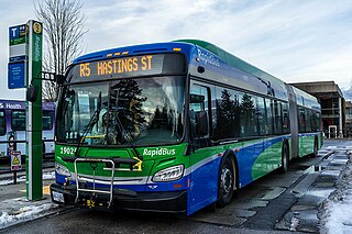
    The R5 Hastings St is an express bus service with bus rapid transit elements in Metro Vancouver, Canada. Part of TransLink's RapidBus network, it travels along Hastings Street, a major east–west route, and connects Simon Fraser University to the SkyTrain system's Burrard station on the Expo Line in Downtown Vancouver. It replaced the 95 B-Line route on January 6, 2020.

    <span class="mw-page-title-main">Sunnyside, Surrey</span> Neighbourhood in Lower Mainland, British Columbia, Canada

    Sunnyside is a neighbourhood of South Surrey, which in turn is a region of Surrey, British Columbia, Canada.

    The 400-series highways were a pair of controlled-access highways located in the southwestern portion of the Canadian province of British Columbia, forming a special subset of the provincial highway system. Modelled after the 400-Series Highways in Ontario, 400-series designations were introduced in 1964 in conjunction with the completion of the Trans-Canada Highway freeway between Vancouver and Clearbrook ; however, unlike their Ontario counterparts, both routes had signalized sections. The 400-series system never expanded beyond two freeways, and in 1973 Highways 401 and 499 were renumbered 1 and 99 respectively, while the former routes were assigned the 'A' suffix.

    <span class="mw-page-title-main">King George Boulevard</span>

    King George Boulevard is a major arterial road in Surrey, British Columbia, Canada. The 26-kilometre (16 mi) route begins at Highway 99, 1.6 kilometres (1.0 mi) north of the Peace Arch Border Crossing with the United States, and runs generally northwest to the south end of the Pattullo Bridge, a crossing of the Fraser River that connects Surrey with New Westminster. The majority of the route varies from four to six lanes, and some sections in the north run parallel to the Expo Line, which has two adjacent SkyTrain stations: Scott Road station in South Westminster, and King George station in the Surrey City Centre district.

    Marine Drive is the name for three major roadways in Greater Vancouver, British Columbia, Canada. The roads are known for running parallel to major bodies of water, with some sections being a major arterial road, while other serve local traffic. Marine Way is the name applied to a section of Marine Drive that was bypassed in the early 1980s.

    References

    1. 1 2 3 4 Google (September 30, 2020). "Highway 99A in Greater Vancouver, BC" (Map). Google Maps . Google. Retrieved September 30, 2020.
    2. Corporate Report No: R207 (PDF) (Report). City of Surrey. November 16, 2009. Archived from the original (PDF) on July 22, 2017. Retrieved October 16, 2020.
    3. 1 2 3 Landmark Kilometre Inventory (PDF). British Columbia Ministry of Transportation and Infrastructure (Report). Cypher Consulting. July 2021. Retrieved 2021-09-14.
    4. The H.M. Gousha Company (1951). "Vancouver and Vicinity" (Map). Shell Map of Vancouver and Victoria, B.C. The Shell Oil Company.
    5. 1 2 The H.M. Gousha Company (1951). "Street Map of Vancouver" (Map). Shell Map of Vancouver and Victoria, B.C. The Shell Oil Company.
    6. 1 2 "Douglas Road". Heritage Burnaby. City of Burnaby. Retrieved October 12, 2020.
    7. "Grandview Highway North - Greenway/Bikeway Traffic Plan". City of Vancouver. February 22, 2000. Retrieved October 12, 2020.
    Template:Attached KML/British Columbia Highway 99A
    KML is not from Wikidata