Ålkistan

Last updated
Alkistan in 1900 and 2006. Aalkistan 1900.jpg
Ålkistan in 1900 and 2006.

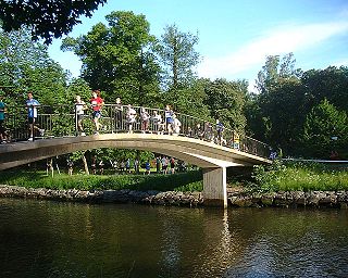
Ålkistan (Swedish: "The Eel Hatch") is the name of a canal, and the surrounding area, north of Stockholm, Sweden. The canal connects Lilla Värtan to Lake Brunnsviken, and delimits Bergshamra, the northern part of Solna, from the northern part of Djurgården.

Swedish language North Germanic language spoken in Sweden

Swedish is a North Germanic language spoken natively by 10 million people, predominantly in Sweden, and in parts of Finland, where it has equal legal standing with Finnish. It is largely mutually intelligible with Norwegian and to some extent with Danish, although the degree of mutual intelligibility is largely dependent on the dialect and accent of the speaker. Both Norwegian and Danish are generally easier for Swedish speakers to read than to listen to because of difference in accent and tone when speaking. Swedish is a descendant of Old Norse, the common language of the Germanic peoples living in Scandinavia during the Viking Era. It has the most speakers of the North Germanic languages.

Canal man-made channel for water

Canals, or navigations, are human-made channels, or artificial waterways, for water conveyance, or to service water transport vehicles.

Stockholm Capital city in Södermanland and Uppland, Sweden

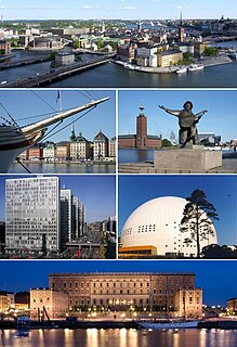
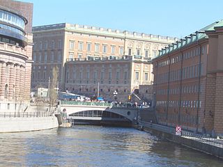
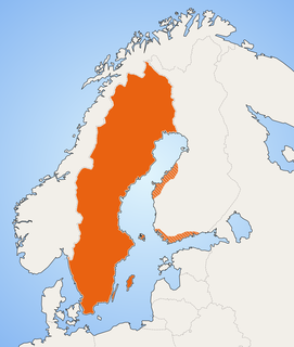
Stockholm is the capital of Sweden and the most populous urban area in the Nordic countries; 960,031 people live in the municipality, approximately 1.5 million in the urban area, and 2.3 million in the metropolitan area. The city stretches across fourteen islands where Lake Mälaren flows into the Baltic Sea. Just outside the city and along the coast is the island chain of the Stockholm archipelago. The area has been settled since the Stone Age, in the 6th millennium BC, and was founded as a city in 1252 by Swedish statesman Birger Jarl. It is also the capital of Stockholm County.

The name Ålkistan first appears on a map of Djurgården dated 1649, pointing out Åhlekijstetorpet ("The Eel Hatch Cottage"), Åhlekijstebackan ("The Eel Hatch Hillside") and Åhlekijste wijken ("The Eel Hatch Bay"). In a rivulet leading to the bay eels were caught using cages (in Swedish called kista, "coffin"), which gave the area its present name. The cottage is mentioned as a tavern in 1789. [1]

Djurgården island and urban district in Stockholm, Sweden

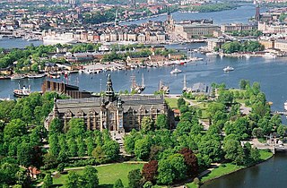
Djurgården or, more officially, Kungliga Djurgården is an island in central Stockholm, Sweden. Djurgården is home to historical buildings and monuments, museums, galleries, the amusement park Gröna Lund, the open-air museum Skansen, the small residential area Djurgårdsstaden, yacht harbours, and extensive stretches of forest and meadows. It is one of the Stockholmers' favorite recreation areas and tourist destinations alike, attracting over 10 million visitors per year, of which some 5 million come to visit the museums and amusement park. The island belongs to the National City park founded in 1995. Since the 15th century the Swedish monarch has owned or held the right of disposition of Royal Djurgården. Today, this right is exercised by the Royal Djurgården Administration which is a part of the Royal Court of Sweden.

Eel order of fishes

An eel is any ray-finned fish belonging to the order Anguilliformes, which consists of four suborders, 20 families, 111 genera, and about 800 species. Eels undergo considerable development from the early larval stage to the eventual adult stage, and most are predators. The term “eel” originally referred to the European eel, and the name of the order means “European eel-shaped.”

Tavern place of business where people gather to drink alcoholic beverages and be served food

A tavern is a place of business where people gather to drink alcoholic beverages and be served food, and in most cases, where travelers receive lodging. An inn is a tavern that has a license to put up guests as lodgers. The word derives from the Latin taberna whose original meaning was a shed, workshop, stall, or pub.

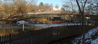
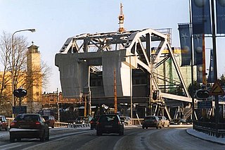
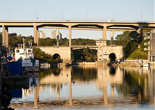
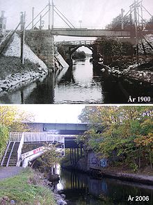
By the mid-19th century, mud threatened to cork the rivulet, which would effectively have turned Lake Brunnsviken, being used as refuse dump as it was, into a sewer. King Charles XV therefore ordered the present canal to be constructed in 1863, which lowered the water level of Brunnsviken by two metres. A 6.5-metre-wide (21 ft) wooden bridge with a mobile flap leading over the canal was added at the same time. The bridge was substituted in 1937 by a 23-metre-wide (75 ft) bridge with an 18-metre-wide (59 ft) roadway and a horizontal clearance of 8 metres, rebuilt in 1972. [1] [2]

Charles XV of Sweden King of Sweden and Norway between 1859-1872

Charles XV & IV also Carl ; Swedish: Karl XV and Norwegian: Karl IV was King of Sweden and Norway from 1859 until his death. Though known as King Charles XV in Sweden, he was actually the ninth Swedish king by that name, as his predecessor Charles IX had adopted a numeral according to a fictitious history of Sweden.

There was a railway stop at Ålkistan from 1885 until 1923, at the Roslag Railway. [3] The railway is still operational, but the trains do not stop at Ålkistan anymore.

Roslagsbanan narrow gauge commuter railway in Stockholm

Roslagsbanan is a narrow gauge urban railway system in Roslagen, Stockholm County, Sweden. Its combined route length is 65 kilometres and there are 38 stations. It is built to the Swedish three foot gauge.

As of 2007, no ships wider than 4.0 metres or deeper than 1.6 metres are allowed in the canal. Next to Ålkistan is a residential area, Sfären ("The Sphere"), with a local centre. [4]

Related Research Articles

Centralbron bridge between Södermalm and Norrmalm in Stockholm, Sweden

Centralbron is one of the major traffic routes in central Stockholm, Sweden, connecting the northern district Norrmalm to the southern Södermalm.

Stallbron bridge between Helgeandsholmen and Gamla stan in Stockholm, Sweden

Stallbron is an arch bridge located in Gamla stan, the old town in central Stockholm, Sweden. Stretching some 20 meters over Stallkanalen it connects Riksgatan passing through the Parliament Building on Helgeandsholmen to the square Mynttorget on Stadsholmen from where Västerlånggatan extends it further south.

Skeppsholmsbron bridge between Blasieholmen and Skeppsholmen in Stockholm, Sweden

Skeppsholmsbron is in central Stockholm, Sweden, connecting Blasieholmen to Skeppsholmen.

Stadshusbron road bridge between Norrmalm and Kungsholmen in Stockholm, Sweden

Stadshusbron, formerly known as Nya Kungsholmsbron is a bridge in central Stockholm, Sweden located just north of the Stockholm City Hall. Stretching over Klara sjö, it connects mainland Norrmalm on the eastern shore to the island Kungsholmen on the western shore.

Klarabergsviadukten viaduct in central Stockholm, Sweden

Klarabergsviadukten is a reinforced concrete bridge and a viaduct in central Stockholm, Sweden. Stretching over Klara Sjö, it connects Norrmalm to Kungsholmen.

Kungsbron road bridge between Kungsholmen and Norrmalm in Stockholm, Sweden

Kungsbron is a double bridge in central Stockholm, Sweden. Stretching over Klara Sjö, it connects Norrmalm to Kungsholmen.

Barnhusbron bridge between Norrmalm and Kungsholmen in Stockholm, Sweden

Barnhusbron is a bridge in central Stockholm, Sweden. Passing over Barnhusviken, it connects Kungsholmen to Norrmalm. It is 23 metres wide and 290 metres long with a maximum span of 64.5 metres. The roadway is made of prestressed concrete except for two non-tensioned concrete section in its eastern end.

Ekelundsbron bridge between Kungsholmen and Solna, Sweden

Ekelundsbron is a bridge in Stockholm, Sweden. Passing over the canal Karlbergskanalen, it connects the city district Stadshagen on Kungsholmen to the northern suburb Solna.

Djurgårdsbron bridge between Östermalm and Djurgården in Stockholm, Sweden

Djurgårdsbron is a bridge in central Stockholm, Sweden. Designed by Carl Fraenell and built for the Stockholm World's Fair 1897, the present bridge forms a southern extension to the boulevard Narvavägen, thus connecting mainland Östermalm to the island Djurgården. It is one of four bridges stretching from Djurgården, the others being Djurgårdsbrunnsbron, Beckholmsbron, and Lilla Sjötullsbron.

Djurgårdsbrunnsbron bridge between Gärdet and Djurgården in Stockholm, Sweden

Djurgårdsbrunnsbron is a bridge in central Stockholm, Sweden, connecting northern and southern Djurgården. It is the city's only remaining swing bridge, the default bridge type in Stockholm during the 19th century. It has been closed since 1966.

Mariebergsbron road bridge between Lilla Essingen and Marieberg in Stockholm, Sweden

Mariebergsbron is a bridge in central Stockholm, Sweden. Formerly known as Lilla Essingebron, it connects the islands Kungsholmen to Lilla Essingen. The current name is due to the vicinity to the city district Marieberg.

Långholmsbron bridge between Södermalm and Långholmen in Stockholm, Sweden

Långholmsbron is a bridge in central Stockholm, Sweden. Connecting the major island Södermalm to the minor island Långholmen, it forms an extension to the street Bergsundsgatan.

Pålsundsbron bridge between Södermalm and Långholmen in Stockholm, Sweden

Pålsundsbron is a bridge in central Stockholm, Sweden. Stretching over the small water course Pålsundet, the bridge connects the major island Södermalm to the minor island Långholmen.

Danviksbro bascule bridge between Stockholm and Nacka, Sweden

Danviksbron or, alternatively, Danviksbro is a bascule bridge in central Stockholm, Sweden, connecting the eastern end of Södermalm to the eastern municipality Nacka. Under the bridge, the canal Hammarbykanalen carries the water of Hammarby Sjö over to Saltsjön. The bridge, actually two separate bridges, carries the railway Saltsjöbanan and a road.

Skansbron bascule bridge between Södermalm and Johanneshov in Stockholm, Sweden

Skansbron is a bascule bridge in central Stockholm, Sweden. Stretching over the canal Hammarbykanalen, it connects the major island Södermalm to the southern mainland district Södra Hammarbyhamnen.

Fredhällsbron highway bridge between Lilla Essingen and Fredhäll in Stockholm, Sweden

Fredhällsbron is a bridge in central Stockholm, Sweden. It connects the island Lilla Essingen to Fredhäll, a district on the island Kungsholmen, and, forming a section of the Essingeleden motorway, connects the Lilla Essingen interchange to the tunnel Fredhällstunneln.

Solnabron former bridge between Solna and Vasastan in Stockholm, Sweden

Solnabron is a viaduct in Sweden. Spanning the Norra Station area and the Norra länken motorway, it links the municipalities of Stockholm and Solna.

Huvudstabron bridge between Huvudsta, Solna and Ulvsunda, Stockholm, Sweden

Huvudstabron is a bridge in Sweden. Stretching over Bällstaviken it connects the industrial area Ulvsunda in the municipality Stockholm to the city district Huvudsta in the municipality Solna.

Sickla kanalbro highway bridge over Sickla canal in Stockholm, Sweden

Sickla kanalbro is a bridge in central Stockholm, Sweden. Stretching over Sickla kanal, it connects Södra Hammarbyhamnen to Nacka. The name Sickla is believed to be derived from a 15th-century provincial word, sik, meaning "minor marsh".

Lilla Sjötullsbron footbridge to Djurgården in Stockholm, Sweden

Lilla Sjötullsbron is a concrete pedestrian bridge in central Stockholm, Sweden. Passing over Djurgårdsbrunnskanalen it connects Djurgården island to the mainland north of it.

References

  1. 1 2 "Norrmalm". Stockholms gatunamn (2nd ed.). Stockholm: Kommittén för Stockholmsforskning. 1992. p. 142. ISBN   91-7031-042-4.
  2. Dufwa, Arne (1985). "Broar och viadukter: Ålkistebron". Stockholms tekniska historia: Trafik, broar, tunnelbanor, gator. Uppsala: Stockholms gatukontor and Kommittén för Stockholmsforskning. p. 203. ISBN   91-38-08725-1.
  3. Stig Lundin. "Ålkistan Hp" . Retrieved 15 November 2015.
  4. "Kv Sfären" (in Swedish). Solna Municipality . Retrieved 11 May 2018.

See also

Coordinates: 59°22′32″N18°02′49″E / 59.37556°N 18.04694°E / 59.37556; 18.04694

Geographic coordinate system Coordinate system

A geographic coordinate system is a coordinate system that enables every location on Earth to be specified by a set of numbers, letters or symbols. The coordinates are often chosen such that one of the numbers represents a vertical position and two or three of the numbers represent a horizontal position; alternatively, a geographic position may be expressed in a combined three-dimensional Cartesian vector. A common choice of coordinates is latitude, longitude and elevation. To specify a location on a plane requires a map projection.