Çatak, Alaplı

Last updated
Çatak
Village
Country Flag of Turkey.svg  Turkey
Province Zonguldak Province
District Alaplı
Time zone EET (UTC+2)
  Summer (DST) EEST (UTC+3)

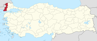
Çatak is a village in Alaplı District, Zonguldak Province, Turkey. [1]

Alaplı Place in Zonguldak, Turkey

Alaplı is a town and district of Zonguldak Province in the Black Sea region of Turkey. It is the westernmost town in Zonguldak Province and is located about 15 km (9.3 mi) south of Karadeniz Ereğli. It has 2 municipalities, one is the centre and the other is named as "Gümeli". The mayor is Nuri Tekin (CHP).

Zonguldak Province Municipality in Turkey

Zonguldak Province is a province along the western Black Sea coast region of Turkey. The province is 3.481 km² in size and has a population of 619,703. Its adjacent provinces are Düzce to the southwest, Bolu to the south, Karabük to the southeast, and Bartın to the east. The capital is Zonguldak.

Turkey Republic in Western Asia

Turkey, officially the Republic of Turkey, is a transcontinental country located mainly in Western Asia, with a smaller portion on the Balkan Peninsula in Southeast Europe. East Thrace, located in Europe, is separated from Anatolia by the Sea of Marmara, the Bosphorous strait and the Dardanelles. Turkey is bordered by Greece and Bulgaria to its northwest; Georgia to its northeast; Armenia, the Azerbaijani exclave of Nakhchivan and Iran to the east; and Iraq and Syria to the south. Ankara is its capital but Istanbul is the country's largest city. Approximately 70 to 80 per cent of the country's citizens identify as Turkish. Kurds are the largest minority; the size of the Kurdish population is a subject of dispute with estimates placing the figure at anywhere from 12 to 25 per cent of the population.
Related Research Articles

Edirne Province Province of Turkey in West Marmara

Edirne Province is a Turkish province located in East Thrace. Part of European Turkey, it is one of only three provinces located entirely within continental Europe. Edirne Province is bordered by Tekirdağ Province and Kırklareli Province to the east, and the Gallipoli peninsula of Çanakkale Province to the south-east. It shares an international borders with Bulgaria to the north and Greece to the west.

Kitimat River Provincial Park is a provincial park in British Columbia, Canada.

The Polytechnic University of Bari is a university located in Bari, Italy. It was founded in 1990 and it is organized in 3 Faculties.

Bencroft Hill Meadows is a 5.1 hectare biological Site of Special Scientific Interest some 3 miles (5 km) to the east of the town of Chippenham in Wiltshire, England, notified in 1988.

Roman Catholic Archdiocese of NDjaména archdiocese

The Archdiocese of N'Djaména is the Metropolitan See for the Ecclesiastical province of N’Djaména in Chad.

Lipno is a village in the administrative district of Gmina Jeżewo, within Świecie County, Kuyavian-Pomeranian Voivodeship, in north-central Poland.

Rudnica is a village in the administrative district of Gmina Wałcz, within Wałcz County, West Pomeranian Voivodeship, in north-western Poland. Main tourist attraction within Rudnica is Rudnica Park Linowy, second largest of its type in Poland.

Jacewicze is a village in the administrative district of Gmina Bielsk Podlaski, within Bielsk County, Podlaskie Voivodeship, in north-eastern Poland.

Kraska is a village in the administrative district of Gmina Miastkowo, within Łomża County, Podlaskie Voivodeship, in north-eastern Poland.

Sikory-Pawłowięta Village in Podlaskie, Poland

Sikory-Pawłowięta is a village in the administrative district of Gmina Kobylin-Borzymy, within Wysokie Mazowieckie County, Podlaskie Voivodeship, in north-eastern Poland.

Ryongchon Station

Ryongch'ŏn Station is a railway station in Ryongch'ŏn-ŭp, Ryongch'ŏn County, North P'yŏngan Province, North Korea. It is the junction point of the P'yŏngŭi and Tasado lines of the Korean State Railway.

Dodurga Dam is a dam in Sinop Province, Turkey, built between 1990 and 2000. The development was backed by the Turkish State Hydraulic Works.

Gölköy Dam is a dam in Bolu, Turkey, built between 1965 and 1970. The development was backed by the Turkish State Hydraulic Works.

Gülüç Dam is a dam in Zonguldak Province, Turkey, built between 1964 and 1966. The development was backed by the Turkish State Hydraulic Works.

Korbul is a village in the municipality of Vranje, Serbia. According to the 2002 census, the village has a population of 14 people.

Çalköy is a village in the District of Vezirköprü, Samsun Province, Turkey.

Sofular is a village in the Vezirköprü, Samsun Province, Turkey.

Metropolitan City of Reggio Calabria Metropolitan City in Calabria, Italy

The Metropolitan City of Reggio Calabria is a future metropolitan city in the Calabria region of southern Italy. Its capital, Reggio di Calabria, will replace the Province of Reggio Calabria.

Halife is a village in the district of Kastamonu, Kastamonu Province, Turkey.

Crenides or Krenides, or Cranides or Kranides (Κρανίδες), was a town on the Pontic coast of Bithynia, according to Arrian 60 stadia east of Sandaraca; according to Marcian only 20 stadia. It was between Heraclea and the mouth of the Billaeus.

References

  1. "Koyler" (in Turkish). Yerelnet.org. Retrieved 1 November 2015.

Coordinates: 41°06′41″N31°27′28″E / 41.1114°N 31.4578°E / 41.1114; 31.4578

Geographic coordinate system Coordinate system

A geographic coordinate system is a coordinate system that enables every location on Earth to be specified by a set of numbers, letters or symbols. The coordinates are often chosen such that one of the numbers represents a vertical position and two or three of the numbers represent a horizontal position; alternatively, a geographic position may be expressed in a combined three-dimensional Cartesian vector. A common choice of coordinates is latitude, longitude and elevation. To specify a location on a plane requires a map projection.