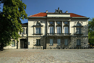
Tyszkiewicz Palace, also known as Tyszkiewicz–Potocki Palace, is a rebuilt palace at 32 Krakowskie Przedmieście in Warsaw, Poland. It is one of the most beautiful Neoclassical-style buildings in the city.
Rowy is a village in the administrative district of Gmina Kleszczele, within Hajnówka County, Podlaskie Voivodeship, in north-eastern Poland, close to the border with Belarus.
Moczydły-Kukiełki is a village in the administrative district of Gmina Perlejewo, within Siemiatycze County, Podlaskie Voivodeship, in north-eastern Poland.

Jaworek is a village in the administrative district of Gmina Czastary, within Wieruszów County, Łódź Voivodeship, in central Poland. It lies approximately 3 kilometres (2 mi) south-west of Czastary, 12 km (7 mi) south-east of Wieruszów, and 102 km (63 mi) south-west of the regional capital Łódź.
Mstów is a village in the administrative district of Gmina Jodłownik, within Limanowa County, Lesser Poland Voivodeship, in southern Poland. It lies approximately 3 kilometres (2 mi) north of Jodłownik, 17 km (11 mi) north-west of Limanowa, and 37 km (23 mi) south-east of the regional capital Kraków.
Kalonka is a village in the administrative district of Gmina Pilawa, within Garwolin County, Masovian Voivodeship, in east-central Poland. It lies approximately 8 kilometres (5 mi) north-east of Pilawa, 14 km (9 mi) north of Garwolin, and 47 km (29 mi) south-east of Warsaw.
Budy Budzkie is a village in the administrative district of Gmina Strzegowo, within Mława County, Masovian Voivodeship, in east-central Poland.
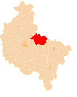
Joniec-Kolonia is a village in the administrative district of Gmina Joniec, within Płońsk County, Masovian Voivodeship, in east-central Poland. It lies approximately 13 kilometres (8 mi) east of Płońsk and 52 km (32 mi) north-west of Warsaw.
Henrysin is a village in the administrative district of Gmina Kosów Lacki, within Sokołów County, Masovian Voivodeship, in east-central Poland.
Danabórz is a village in the administrative district of Gmina Wągrowiec, within Wągrowiec County, Greater Poland Voivodeship, in west-central Poland. It lies approximately 10 kilometres (6 mi) north of Wągrowiec and 59 km (37 mi) north of the regional capital Poznań.
Gądków Wielki is a village in the administrative district of Gmina Torzym, within Sulęcin County, Lubusz Voivodeship, in western Poland. It lies approximately 11 kilometres (7 mi) south-west of Torzym, 26 km (16 mi) south-west of Sulęcin, 50 km (31 mi) north-west of Zielona Góra, and 58 km (36 mi) south of Gorzów Wielkopolski.
Pasałka is a settlement in the administrative district of Gmina Łagów, within Świebodzin County, Lubusz Voivodeship, in western Poland.
Jabłończ Wielka is a settlement in the administrative district of Gmina Studzienice, within Bytów County, Pomeranian Voivodeship, in northern Poland. It lies approximately 8 kilometres (5 mi) north of Studzienice, 7 km (4 mi) north-east of Bytów, and 72 km (45 mi) west of the regional capital Gdańsk.
Mosiny is a village in the administrative district of Gmina Człuchów, within Człuchów County, Pomeranian Voivodeship, in northern Poland. It lies approximately 7 kilometres (4 mi) south of Człuchów and 121 km (75 mi) south-west of the regional capital Gdańsk.
Teklowo is a settlement in the administrative district of Gmina Stężyca, within Kartuzy County, Pomeranian Voivodeship, in northern Poland. It lies approximately 9 kilometres (6 mi) north-east of Stężyca, 14 km (9 mi) south-west of Kartuzy, and 40 km (25 mi) west of the regional capital Gdańsk.
Grabowiec is a village in the administrative district of Gmina Bobowo, within Starogard County, Pomeranian Voivodeship, in northern Poland. It lies approximately 4 kilometres (2 mi) north-east of Bobowo, 8 km (5 mi) south-east of Starogard Gdański, and 52 km (32 mi) south of the regional capital Gdańsk.
Kisewo is a village in the administrative district of Gmina Łęczyce, within Wejherowo County, Pomeranian Voivodeship, in northern Poland. It lies approximately 3 kilometres (2 mi) west of Łęczyce, 29 km (18 mi) west of Wejherowo, and 59 km (37 mi) north-west of the regional capital Gdańsk.
Stare Jegławki is a village in the administrative district of Gmina Srokowo, within Kętrzyn County, Warmian-Masurian Voivodeship, in northern Poland, close to the border with the Kaliningrad Oblast of Russia.
Bruchwałd is a settlement in the administrative district of Gmina Purda, within Olsztyn County, Warmian-Masurian Voivodeship, in northern Poland. It lies approximately 8 kilometres (5 mi) west of Purda and 12 km (7 mi) south-east of the regional capital Olsztyn.
Sarnowo is a settlement in the administrative district of Gmina Bobolice, within Koszalin County, West Pomeranian Voivodeship, in north-western Poland.