Malerzów is a village in the administrative district of Gmina Dobroszyce, within Oleśnica County, Lower Silesian Voivodeship, in south-western Poland. Prior to 1945 it was in Germany.

Gać is a village in the administrative district of Gmina Oława, within Oława County, Lower Silesian Voivodeship, in southwestern Poland. It lies approximately 7 kilometres (4.3 mi) southeast of Oława, 36 kilometres (22 mi) southeast of the regional capital Wrocław, and has a population of 449. Prior to 1945 it was a part of Germany.
Józefowo is a village in the administrative district of Gmina Włocławek, within Włocławek County, Kuyavian-Pomeranian Voivodeship, in north-central Poland. It lies approximately 9 kilometres (6 mi) east of Włocławek and 59 km (37 mi) south-east of Toruń.
Wymysłowo is a village in the administrative district of Gmina Więcbork, within Sępólno County, Kuyavian-Pomeranian Voivodeship, in north-central Poland. It lies approximately 15 kilometres (9 mi) west of Więcbork, 20 km (12 mi) south-west of Sępólno Krajeńskie, and 56 km (35 mi) north-west of Bydgoszcz.
Dębina is a village in the administrative district of Gmina Uchanie, within Hrubieszów County, Lublin Voivodeship, in eastern Poland.
Brzozowy Borek is a village in the administrative district of Gmina Dąbrowa Białostocka, within Sokółka County, Podlaskie Voivodeship, in north-eastern Poland.
Kierkielewszczyzna is a settlement in the administrative district of Gmina Kuźnica, within Sokółka County, Podlaskie Voivodeship, in north-eastern Poland, close to the border with Belarus.
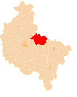
Rudzisko is a village in the administrative district of Gmina Szczerców, within Bełchatów County, Łódź Voivodeship, in central Poland. It lies approximately 4 kilometres (2 mi) north of Szczerców, 19 km (12 mi) west of Bełchatów, and 53 km (33 mi) south-west of the regional capital Łódź.
Rędziny is a village in the administrative district of Gmina Żytno, within Radomsko County, Łódź Voivodeship, in central Poland. It lies approximately 5 kilometres (3 mi) north of Żytno, 17 km (11 mi) south-east of Radomsko, and 91 km (57 mi) south of the regional capital Łódź.
Kalina Mała is a village in the administrative district of Gmina Miechów, within Miechów County, Lesser Poland Voivodeship, in southern Poland. It lies approximately 6 kilometres (4 mi) east of Miechów and 36 km (22 mi) north of the regional capital Kraków.
Zahajki-Kolonia is a village in the administrative district of Gmina Wyryki, within Włodawa County, Lublin Voivodeship, in eastern Poland.
Szewna is a village in the administrative district of Gmina Bodzechów, within Ostrowiec County, Świętokrzyskie Voivodeship, in south-central Poland. It lies approximately 4 kilometres (2 mi) south-west of Ostrowiec Świętokrzyski and 53 km (33 mi) east of the regional capital Kielce.
Wróble-Wargocin is a village in the administrative district of Gmina Maciejowice, within Garwolin County, Masovian Voivodeship, in east-central Poland.
Bieliny is a village in the administrative district of Gmina Nowe Miasto nad Pilicą, within Grójec County, Masovian Voivodeship, in east-central Poland.

Dziekanów Nowy is a village in the administrative district of Gmina Łomianki, within Warsaw West County, Masovian Voivodeship, in east-central Poland. It lies approximately 6 kilometres (4 mi) north-west of Łomianki, 17 km (11 mi) north of Ożarów Mazowiecki, and 21 km (13 mi) north-west of Warsaw.
Kolebki-Frąsin is a village in the administrative district of Gmina Ślesin, within Konin County, Greater Poland Voivodeship, in west-central Poland.
Sypniewo-Kolonia is a settlement in the administrative district of Gmina Jastrowie, within Złotów County, Greater Poland Voivodeship, in west-central Poland.
Warszkowo is a village in the administrative district of Gmina Sławno, within Sławno County, West Pomeranian Voivodeship, in north-western Poland. It lies approximately 2 kilometres (1 mi) east of Sławno and 175 km (109 mi) north-east of the regional capital Szczecin.
Bieńczyce is a village in the administrative district of Gmina Nowogard, within Goleniów County, West Pomeranian Voivodeship, in north-western Poland. It lies approximately 13 kilometres (8 mi) east of Nowogard, 34 km (21 mi) east of Goleniów, and 53 km (33 mi) north-east of the regional capital Szczecin.

Harrys Brook, also known as the H. Greenlands Brook, is a tributary of the Millstone River in Mercer County, New Jersey in the United States.