Gorzyce is a village in the administrative district of Gmina Żnin, within Żnin County, Kuyavian-Pomeranian Voivodeship, in north-central Poland. It lies approximately 9 kilometres (6 mi) north-west of Żnin and 39 km (24 mi) south-west of Bydgoszcz.
Krzyżownica is a village in the administrative district of Gmina Mogilno, within Mogilno County, Kuyavian-Pomeranian Voivodeship, in north-central Poland. It lies approximately 9 kilometres (6 mi) south-west of Mogilno and 60 km (37 mi) south of Bydgoszcz.
Bzury is a village in the administrative district of Gmina Szczuczyn, within Grajewo County, Podlaskie Voivodeship, in north-eastern Poland. It lies approximately 5 kilometres (3 mi) north-east of Szczuczyn, 10 km (6 mi) south-west of Grajewo, and 76 km (47 mi) north-west of the regional capital Białystok.
Krupy is a village in the administrative district of Gmina Michów, within Lubartów County, Lublin Voivodeship, in eastern Poland. It lies approximately 7 kilometres (4 mi) north of Michów, 22 km (14 mi) north-west of Lubartów, and 41 km (25 mi) north of the regional capital Lublin.
Mysiakowiec is a village in the administrative district of Gmina Poświętne, within Opoczno County, Łódź Voivodeship, in central Poland. It lies approximately 6 kilometres (4 mi) north of Poświętne, 23 km (14 mi) north of Opoczno, and 65 km (40 mi) east of the regional capital Łódź.
Malczyn is a village in the administrative district of Gmina Nasielsk, within Nowy Dwór Mazowiecki County, Masovian Voivodeship, in east-central Poland. It lies approximately 6 kilometres (4 mi) west of Nasielsk, 17 km (11 mi) north of Nowy Dwór Mazowiecki, and 46 km (29 mi) north-west of Warsaw.
Ruszkowo is a village in the administrative district of Gmina Nasielsk, within Nowy Dwór Mazowiecki County, Masovian Voivodeship, in east-central Poland. It lies approximately 5 kilometres (3 mi) west of Nasielsk, 17 km (11 mi) north of Nowy Dwór Mazowiecki, and 45 km (28 mi) north-west of Warsaw.
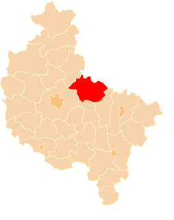
Goślinowo is a village in the administrative district of Gmina Gniezno, within Gniezno County, Greater Poland Voivodeship, in west-central Poland. It lies approximately 6 kilometres (4 mi) north of Gniezno and 53 km (33 mi) north-east of the regional capital Poznań.
Krzyszczewo is a village in the administrative district of Gmina Gniezno, within Gniezno County, Greater Poland Voivodeship, in west-central Poland. It lies approximately 6 kilometres (4 mi) north of Gniezno and 50 km (31 mi) north-east of the regional capital Poznań.
Karczewo is a village in the administrative district of Gmina Kiszkowo, within Gniezno County, Greater Poland Voivodeship, in west-central Poland. It lies approximately 3 kilometres (2 mi) west of Kiszkowo, 27 km (17 mi) west of Gniezno, and 29 km (18 mi) north-east of the regional capital Poznań.
Ujazd is a village in the administrative district of Gmina Kiszkowo, within Gniezno County, Greater Poland Voivodeship, in west-central Poland. It lies approximately 5 kilometres (3 mi) east of Kiszkowo, 20 km (12 mi) west of Gniezno, and 34 km (21 mi) north-east of the regional capital Poznań.
Węgorzewo is a village in the administrative district of Gmina Kiszkowo, within Gniezno County, Greater Poland Voivodeship, in west-central Poland. It lies approximately 3 kilometres (2 mi) south-east of Kiszkowo, 23 km (14 mi) west of Gniezno, and 33 km (21 mi) north-east of the regional capital Poznań.
Bielawy is a village in the administrative district of Gmina Kłecko, within Gniezno County, Greater Poland Voivodeship, in west-central Poland. It lies approximately 6 kilometres (4 mi) south of Kłecko, 13 km (8 mi) north-west of Gniezno, and 41 km (25 mi) north-east of the regional capital Poznań. It has a population of 45 people.
Dębnica is a village in the administrative district of Gmina Kłecko, within Gniezno County, Greater Poland Voivodeship, in west-central Poland. It lies approximately 7 kilometres (4 mi) south-east of Kłecko, 10 km (6 mi) north-west of Gniezno, and 44 km (27 mi) north-east of the regional capital Poznań.
Lubiń is a village in the administrative district of Gmina Trzemeszno, within Gniezno County, Greater Poland Voivodeship, in west-central Poland. It lies approximately 4 kilometres (2 mi) north-east of Trzemeszno, 19 km (12 mi) east of Gniezno, and 68 km (42 mi) east of the regional capital Poznań.

Niewolno is a village in the administrative district of Gmina Trzemeszno, within Gniezno County, Greater Poland Voivodeship, in west-central Poland. It lies approximately 2 kilometres (1 mi) north of Trzemeszno, 16 km (10 mi) east of Gniezno, and 65 km (40 mi) east of the regional capital Poznań.
Łuszczanów is a village in the administrative district of Gmina Jarocin, within Jarocin County, Greater Poland Voivodeship, in west-central Poland. It lies approximately 10 kilometres (6 mi) north-east of Jarocin and 62 km (39 mi) south-east of the regional capital Poznań.
Mostki is a village in the administrative district of Gmina Sompolno, within Konin County, Greater Poland Voivodeship, in west-central Poland. It lies approximately 8 kilometres (5 mi) south-east of Sompolno, 28 km (17 mi) north-east of Konin, and 114 km (71 mi) east of the regional capital Poznań.
Wielowieś is a village in the administrative district of Gmina Międzychód, within Międzychód County, Greater Poland Voivodeship, in west-central Poland. It lies approximately 3 kilometres (2 mi) south-east of Międzychód and 72 km (45 mi) west of the regional capital Poznań.
Marcewo is a village in the administrative district of Gmina Słupca, within Słupca County, Greater Poland Voivodeship, in west-central Poland. It lies approximately 8 kilometres (5 mi) north-east of Słupca and 70 km (43 mi) east of the regional capital Poznań.