
A wharf, quay, staith, or staithe is a structure on the shore of a harbour or on the bank of a river or canal where ships may dock to load and unload cargo or passengers. Such a structure includes one or more berths, and may also include piers, warehouses, or other facilities necessary for handling the ships. Wharves are often considered to be a series of docks at which boats are stationed. A marginal wharf is connected to the shore along its full length.

Cathays is a district and community in the centre of Cardiff, capital of Wales. It is an old suburb of Cardiff established in 1875. It is densely populated and contains many Victorian terraced houses. The area falls into the Cathays ward. It is the third most populous community in Cardiff, having a population of 18,002 in 2011.

A yard is an area of land immediately adjacent to one or more buildings. It may be either enclosed or open. The word may come from the same linguistic root as the word garden and has many of the same meanings.

Becca Hall is a country residence situated in Aberford, Leeds, West Yorkshire, Yorkshire, at OS grid reference Lat.53:50:35N Lon.1:22:08W. It is situated on Becca Lane within the old Gascoigne estate. The house is a Grade II listed building.
Tyning is a name-element occurring commonly in north-east Somerset, England—most of all in the Bath area, though also as far as Cheddar in the south-west, and over the borders into Wiltshire and Gloucestershire. It is used of three woodlands, of several farms, and also in at least a score of street names, as well as the names of schools in Staple Hill and in Henbury in Bristol, and in the name used of a part of the town of Radstock. There are outlying uses in Sussex and Ulster, and in street names in Droitwich, Walsall, and Wolverhampton.

Meursault is a commune in the Côte-d'Or department and region of Bourgogne-Franche-Comté in eastern France.

Blennerhasset and Torpenhow is a civil parish in Cumbria, England. According to the 2001 census it had a population of 437, reducing to 423 at the 2011 Census. It includes the villages of Blennerhasset grid reference NY178415 and Torpenhow at NY202397 and the smaller settlement of Kirkland Guards at NY187401. It is located just outside the Lake District National Park. Baggrow railway station was immediately north of Blennerhasset.

Felixkirk is a village and civil parish in the Hambleton District of North Yorkshire, England. The village is situated about three miles north-east of Thirsk. The population of the civil parish was estimated at 100 in 2014.
Assarting is the act of clearing forested lands for use in agriculture or other purposes. In English land law, it was illegal to assart any part of a royal forest without permission. This was the greatest trespass that could be committed in a forest, being more than a waste: while waste of the forest involves felling trees and shrubs, which can regrow, assarting involves completely uprooting all trees—the total extirpation of the forested area.

Wade's Causeway is a sinuous, linear structure of human construction located in the North York Moors national park in North Yorkshire, England. Its origins, age, purpose and extent are subject to ongoing research and debate and have not been reliably established: it was excavated in mid-20th century and dated to the Roman period, but 21st century re-interpretations have suggested a possible Neolithic origin. The name may be used to refer specifically to scheduled ancient monument number 1004876, a length of stone course just over 1 mile (1.6 km) long on Wheeldale Moor. It may be also be applied more broadly to include an additional postulated extension of this structure, incorporating ancient monuments numbers 1004108 and 1004104 which extend to the north and south of Wheeldale for up to 25 miles (40 km). The visible course on Wheeldale Moor consists of an embankment of soil, peat, gravel and loose pebbles 0.7 metres (2.3 ft) in height and 4 to 7 metres in width. The gently cambered embankment is capped with un-mortared and loosely abutted flagstones. Its original form is uncertain since it has been subjected to weathering and human damage.

Hayes is an English language surname. In the United States Census, 1990, Hayes was the 100th most common surname recorded. The oldest record of the surname dates to 1197 in the Eynsham Cartulary of Oxfordshire, where it appears in the form Heise. There are nineteen coats of arms assumed by or granted to individuals with this or a similar surname. Though primarily a surname, "Hayes" sometimes appears as a given name in census records.
A mere is a shallow lake, pond, or wetland, particularly in Great Britain and other parts of western Europe.
Moore is a common English-language surname. It was the 19th most common surname in Ireland in 1901 with 15,417 members. It is the 34th most common surname in Australia, 32nd most common in England, and was the 16th most common surname in the United States in 2000.

Westhay is a village in Somerset, England. It is situated in the parish of Meare, 4 miles (6.4 km) north-west of Glastonbury on the Somerset Levels.
The surname Hayden has several origins. In some cases it is a form of O'Hayden, which is derived from the Irish Ó hÉideáin and Ó hÉidín. These latter surnames mean "descendant of Éideán" and "descendant of Éidín", respectively; the Irish personal names Éideán and Éidín are likely derived from the Irish éideadh, which means "clothes", "armour".
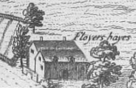
Floyer Hayes was an historic manor in the parish of St Thomas on the southern side of the City of Exeter in Devon, England, from which city it is separated by the River Exe. It took its name from the ancient family of Floyer which held it until the early 17th century, when it was sold to the Gould family. In the 19th century the estate was divided up and the manor house demolished. The parish church of St Thomas, situated a short distance to the west of the house, was burned down in 1645 during the Civil War, and was rebuilt before 1657. Thus no monuments survive there of early lords of the manor, namely the Floyer family.
A deer hay wind, deer fold or elrick is an artificial, natural or modified natural feature used in the culling, capture or management of deer in relation to deer parks or natural woodland and open countryside. These structures have existed for many centuries and after falling out of use and their function having been forgotten the more substantial earth or stone examples have attracted names such as Roman Trenches, Old Fortifications, etc. The hinds were the main target of the hunt. Deer dykes were also a substantial landscape feature built to exclude deer from crops on newly cleared land with ditches on the outside and hedges or wooden fences on top of stone banks.

The place-name Hinton is of Old English origin, and is a common English village name, particularly in Southern England.
