
Amber Valley is a local government district with borough status in the east of Derbyshire, England, taking its name from the River Amber. Its council is based in Ripley. The district covers a semi-rural area lying to the north of the city of Derby. The district contains four main towns whose economy was based on coal mining and remains to some extent influenced by engineering, distribution and manufacturing, holding for instance the headquarters and production site of Thorntons confectionery.

Wirksworth is a market town in the Derbyshire Dales district of Derbyshire, England. Its population of 4,904 in the 2021 census was estimated at 5,220 in 2023. Wirksworth contains the source of the River Ecclesbourne. The town was granted a market charter by Edward I in 1306 and still holds a market on Tuesdays in the Memorial Gardens. The parish church of St Mary's is thought to date from 653. The town developed as a centre for lead mining and stone quarrying. Many lead mines were owned by the Gell family of nearby Hopton Hall.
Heage is a village and former civil parish, now in the parish of Ripley, in the Amber Valley district, in the county of Derbyshire, England. It is situated midway between Belper and Ripley. The village is in the Heage and Ambergate ward, which in the 2011 census had a population of 5,013.
Duffield is a village in the Amber Valley district of Derbyshire, 5 miles (8.0 km) north of Derby. It is centred on the western bank of the River Derwent at the mouth of the River Ecclesbourne. It is within the Derwent Valley Mills World Heritage Area and the southern foothills of the Pennines.

Cromford is a village and civil parish in Derbyshire, England, in the valley of the River Derwent between Wirksworth and Matlock. It is 17 miles (27 km) north of Derby, 2 miles (3.2 km) south of Matlock and 1 mile (1.6 km) south of Matlock Bath. It is first mentioned in the 11th-century Domesday Book as Crumforde, a berewick of Wirksworth, and this remained the case throughout the Middle Ages. The population at the 2011 Census was 1,433. It is principally known for its historical connection with Richard Arkwright and the nearby Cromford Mill, which he built outside the village in 1771. Cromford is in the Derwent Valley Mills World Heritage Site.

The Ecclesbourne Valley Railway is a 9-mile (14.5 km) long heritage railway in Derbyshire. The headquarters of the railway centre on Wirksworth station, and services operate in both directions between Wirksworth and Duffield and from Wirksworth to Ravenstor.

The Derwent Valley line is a railway line from Derby to Matlock in Derbyshire.

Duffield railway station serves the village of Duffield in Derbyshire, England. The station is located on the Midland Main Line from Derby to Leeds, 133 miles 8 chains (214.2 km) north of London St Pancras. It is also a junction with the former branch line to Wirksworth, which is now operated as the Ecclesbourne Valley heritage railway.

Dethick, Lea and Holloway is a civil parish, in the Amber Valley borough of the English county of Derbyshire. The population of the civil parish taken at the 2011 census was 1,027.

Ashleyhay is a village and civil parish in the Amber Valley district of Derbyshire, England, about five miles north-west of Belper. It is also situated one and three-quarters of a mile south of Wirksworth and eleven miles north of Derby city centre. According to the 2001 census it had a population of 105, increasing to 118 at the 2011 Census.

Carsington is a village in the middle of the Derbyshire Dales, England; it adjoins the hamlet of Hopton, and is close to the historic town of Wirksworth and village of Brassington.

Middleton or Middleton-by-Wirksworth is an upland village and civil parish lying approximately one mile NNW of Wirksworth, Derbyshire, England. Middleton was, in 1086, a berewick of the town and manor of Wirksworth. Middleton was formerly known for its lead mines and high quality limestone quarries, including the underground quarry site at Middleton Mine. The Middleton Mine networks underground for approximately 25 miles (40 km) with tunnels on three different levels running under Middleton Moor to the Hopton Wood quarry works at the other side of the hill below Ryder Point Works’. Part of the tunnel collapsed in the 1980s leaving a noticeable depression in the ground above on the eastern side of Middleton Moor. The population of the parish as taken at the 2011 Census was 775.

Shottle is a village approximately 3 miles (4.8 km) south of the market town of Wirksworth in Derbyshire. The population of the civil parish at the 2011 Census was 266.

Shottle and Postern is a civil parish within the Amber Valley district, which is in the county of Derbyshire, England. Sparsely built up with much rural expanse, its population was 270 residents in the 2021 census. The parish is 120 miles (190 km) north west of London, 9 miles (14 km) north west of the county town of Derby, and 2+3⁄4 miles (4.4 km) equidistant of the nearest market towns of Belper and Wirksworth. It shares a boundary with the parishes of Alderwasley, Ashleyhay, Belper, Hazelwood, Idridgehay and Alton, Turnditch and Windley.

Shottle railway station is the second intermediate station on the former Midland Railway branch line to the small town of Wirksworth in Derbyshire. The line is off the Midland Main Line at Duffield railway station, the first being Hazelwood.

Idridgehay railway station is an intermediate station on the former Midland Railway branch line to the town of Wirksworth in Derbyshire. Off the Midland Main Line at Duffield, the line has been reopened as the Ecclesbourne Valley Railway, and Idridgehay station was reopened on 8 March 2008.
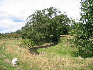
The River Ecclesbourne is a small river in Derbyshire, England, which starts in the upper part of the town of Wirksworth, flows for 9 miles to Duffield, and then enters the River Derwent just outside the town.
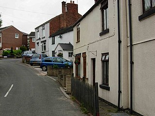
Idridgehay and Alton is a civil parish in the Amber Valley district of Derbyshire, England. The population of the civil parish taken at the 2011 Census was 275. Its principal settlements are the village of Idridgehay and the hamlets of Alton, Idridgehay Green and Ireton Wood.
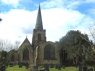
Idridgehay and Alton is a civil parish in the Amber Valley district of Derbyshire, England. The parish contains 27 listed buildings that are recorded in the National Heritage List for England. Of these, one is listed at Grade II*, the middle of the three grades, and the others are at Grade II, the lowest grade. The parish contains the villages of Idridgehay and Alton and the surrounding countryside. Most of the listed buildings are houses, cottages and associated structures, farmhouses and farm buildings. The other listed buildings include former watermills, a public house, a church, a railway station, and the former stationmaster's house.


