Listed buildings in Idridgehay and Alton

Last updated

Idridgehay and Alton is a civil parish in the Amber Valley district of Derbyshire, England. The parish contains 27 listed buildings that are recorded in the National Heritage List for England. Of these, one is listed at Grade II*, the middle of the three grades, and the others are at Grade II, the lowest grade. The parish contains the villages of Idridgehay and Alton and the surrounding countryside. Most of the listed buildings are houses, cottages and associated structures, farmhouses and farm buildings. The other listed buildings include former watermills, a public house, a church, a railway station, and the former stationmaster's house.

Contents

Key

Map all coordinates using: OpenStreetMap  
Download coordinates as: KML
GradeCriteria [1]
II*Particularly important buildings of more than special interest
IIBuildings of national importance and special interest

Buildings

Name and locationPhotographDateNotesGrade
Alton Hall
53°02′55″N1°35′13″W / 53.04853°N 1.58687°W / 53.04853; -1.58687 (Alton Hall)
Late 16th centuryA house that was later extended, it is in gritstone and brick, with quoins, and a tile roof with coped gables and kneelers, some moulded. There are two storeys and an L-shaped plan. In the north wing are mullioned windows and casements, and in both wings are doorways with chamfered quoined surrounds and four-centred arched heads. The south wing has a two-storey canted bay window with sashes, rusticated lintels, and a moulded eaves cornice. [2] [3] II
South Sitch
53°02′06″N1°34′19″W / 53.03496°N 1.57182°W / 53.03496; -1.57182 (South Sitch)
1621 or earlierThe house was extended in 1842. The original part is timber framed with close studding on a stone plinth, and with a thatched roof. There are two storeys and an attic, a front of two bays, and a single-storey extension to the northeast. On the front is a gabled porch with a thatched roof, and a doorway with a four-centred arched head. Some of the windows are casements, and some are mullioned. The extension is roughcast, and has a stone slate roof, and a porch with a four-centred arched lintel. Inside, there is much exposed timber framing. [2] [4] II*
Cliffash Farmhouse and outbuilding
53°02′07″N1°34′54″W / 53.03516°N 1.58177°W / 53.03516; -1.58177 (Cliffash Farmhouse and outbuilding)
17th centuryThe farmhouse and outbuilding are in gritstone, with coped gables and moulded kneelers to the southwest. There are two storeys and an L-shaped plan, with two ranges at right angles. The house has four bays, and contains mullioned windows, and two doorways, one with a massive quoined surround and a Tudor arched soffit to a deep lintel. The outbuilding at right angles has four bays, and contains irregular openings with doorways, square windows, an overloft door approached by external steps, and slit vents. [5] II
Mag Lane Farmhouse
53°01′45″N1°35′08″W / 53.02904°N 1.58569°W / 53.02904; -1.58569 (Mag Lane Farmhouse)
17th centuryThe farmhouse, which was later extended, is in gritstone on a chamfered plinth, with coped gables and moulded kneelers. There are three bays, the right two bays with two storeys and attics, and the left bay lower with two storeys. The doorway has a rectangular fanlight, to its right is a tripartite sash window, the upper floor contains three-light mullioned windows, and in the attic are gabled dormers. The left bay has a sash window in the ground floor and a narrow casement window above. [6] II
White House
53°01′34″N1°34′23″W / 53.02611°N 1.57312°W / 53.02611; -1.57312 (White House)
17th centuryThe house was remodelled and extended in the 18th century. The original part is in gritstone, the extension is in brick, and the roof is tiled. There are two storeys, and a T-shaped plan, with a front range of three bays, and a lower rear wing. The central doorway has a quoined surround, and the windows in the front range are mullioned. In the rear wing is a doorway with a quoined surround, and the windows are casements. [7] II
Alton Mill
53°02′48″N1°34′24″W / 53.04667°N 1.57320°W / 53.04667; -1.57320 (Alton Mill)
1695A water-powered corn mill, later an outbuilding, it is in gritstone, and has a tile roof with coped gables. On the front are irregular openings, including a central doorway with a stepped chamfered lintel, and a loft doorway. In the south gable end are two-light mullioned windows, and on the front are two inscribed and dated stones. [8] II
Wallstone Farmhouse
53°02′20″N1°34′06″W / 53.03888°N 1.56821°W / 53.03888; -1.56821 (Wallstone Farmhouse)
Early 18th centuryThe farmhouse, which was later extended, is in gritstone, the extension is in brick, with quoins, and a tile roof with moulded gables and kneelers. There are two storeys and attics, a front range of five bays, and a rear wing. The central doorway has a moulded surround, and is flanked by pairs of sash windows, each pair under a massive lintel. The windows in the upper floor and rear wing are mullioned, and in the north wall is a doorway with a quoined surround and an initialled and dated lintel. [9] II
Bridge House
53°01′42″N1°33′49″W / 53.02823°N 1.56357°W / 53.02823; -1.56357 (Bridge House)
Late 18th centuryThe house is in gritstone with quoins, and a slate roof with coped gables and moulded kneelers. There are two storeys and two bays. The doorway has a quoined surround, a deep lintel, and a hood mould, and the windows are mullioned with two lights and casements. [10] II
Bridge over Sherbourne Brook
53°01′34″N1°33′53″W / 53.02622°N 1.56480°W / 53.02622; -1.56480 (Bridge over Sherbourne Brook)
Late 18th centuryThe bridge carries Hillcliff Lane over the Sherbourne Brook. It is in gritstone, and consists of two semicircular arches. There are cutwaters on both sides, and above the arches is a string course and a parapet. [11] II
Home Farmhouse
53°01′40″N1°35′06″W / 53.02768°N 1.58493°W / 53.02768; -1.58493 (Home Farmhouse)
Home Farm at Ireton Wood - geograph.org.uk - 290265.jpg
Late 18th centuryThe farmhouse is in red brick with dentilled eaves, and a tile roof with coped gables. There are two storeys and attics, and an L-shaped plan, with a main range of three bays, and a two-storey rear wing. In the centre is a doorway under a segmental arch, the windows have segmental-arched heads and small central opening lights, and the window above the doorway is blocked. [12] II
Black Swan Inn and outbuilding
53°02′12″N1°34′23″W / 53.03654°N 1.57315°W / 53.03654; -1.57315 (Black Swan Inn and outbuilding)
Idridgehay - Black Swan - geograph.org.uk - 2300945.jpg
Early 19th centuryThe public house is in red brick on the front, roughcast on the sides and rear, and has a Welsh slate roof with overhanging eaves. There are two storeys and three bays. In the centre is a gabled open porch flanked by two-storey canted bay windows. The windows have four-centred arched heads and Gothic glazing. The outbuilding, recessed on the right, is in gritstone and has a tile roof. There is a single storey and attics, the openings have segmental heads, and there are three gabled dormers. [13] II
Holme Farmhouse
53°02′14″N1°34′25″W / 53.03720°N 1.57359°W / 53.03720; -1.57359 (Holme Farmhouse)
Early 19th centuryThe farmhouse is in gritstone with a Welsh slate roof. There are two storeys and attics, and three bays. The central doorway has a quoined moulded surround and a rectangular fanlight, and the windows are sashes. [14] II
Rakestone Farmhouse
53°02′11″N1°35′27″W / 53.03627°N 1.59092°W / 53.03627; -1.59092 (Rakestone Farmhouse)
Rakestones Farm - geograph.org.uk - 290250.jpg
Early 19th centuryThe farmhouse is in red brick with a dentilled eaves cornice and a tile roof. There are two storeys and three bays. The central doorway and the windows have four-centred arched heads and Gothic tracery. [15] II
Sherbourne Mill House
53°01′35″N1°33′57″W / 53.02648°N 1.56582°W / 53.02648; -1.56582 (Sherbourne Mill House)
Early 19th centuryThe house is in gritstone on the front, rendered on the sides and rear, and it has a Welsh slate roof with coped gables. There are two storeys and three bays, a central doorway, and sash windows. [16] II
The Cottage
53°01′41″N1°35′08″W / 53.02803°N 1.58553°W / 53.02803; -1.58553 (The Cottage)
Early 19th centuryThe cottage is in gritstone, with a tile roof, two storeys and three bays. The central doorway has a deep lintel, above it is a narrow casement window, and in the other bays are windows with cast iron frames, deep lintels, and central opening lights. [17] II
Ecclesbourne House
53°01′46″N1°33′49″W / 53.02932°N 1.56357°W / 53.02932; -1.56357 (Ecclesbourne House)
c.1845The house is in gritstone and has a Welsh slate roof with bracketed gables. There are two storeys and three bays, with gables at the east and west ends, the latter projecting. In the centre is a gabled porch, and a doorway with a chamfered surround, a four-centred arched head, and a hood mould. The windows are casements with four-centred arched heads and hood moulds. [18] II
Alton Manor and stables
53°03′20″N1°34′47″W / 53.05560°N 1.57986°W / 53.05560; -1.57986 (Alton Manor and stables)
1846–47A small country house designed by George Gilbert Scott in Elizabethan style. It is built in gritstone on a plinth, and has a tile roof with coped gables and moulded kneelers. There are two storeys and attics and an irregular L-shaped plan. The porch in the angle has a doorway with a moulded surround, a four-centred arched head, and decorated spandrels. Above it is a hood mould, a coat of arms, a pointed oriel window, and an octagonal tower with a pierced parapet. The windows are mullioned and transomed. On the garden front is a canted two-storey bay window with an embattled parapet and grotesque spouts. Adjoining the house is a two-storey stable range with a gabled entrance bay containing a moulded four-centred archway, and on the corner is an ogee cupola. [2] [19] II
Lodge to Alton Manor, gates and gate piers
53°03′14″N1°34′37″W / 53.05395°N 1.57683°W / 53.05395; -1.57683 (Lodge to Alton Manor, gates and gate piers)
1846–47The lodge, designed by George Gilbert Scott in Elizabethan style, is in gritstone, and has quoins, and a stone slate roof with coped gables and moulded kneelers. There are two storeys and a cruciform plan. The east front is gabled, and contains a canted bay window, and there is a gabled porch in the angle. The windows are casements, some with mullions. Flanking the entrance to the drive are square gate piers with ball finials, and the ornate gates are in wrought iron. [2] [20] II
Ice house, Alton Manor
53°03′23″N1°34′50″W / 53.05651°N 1.58054°W / 53.05651; -1.58054 (Ice house, Alton Manor)
c. 1846The ice house is a circular stone structure with a brick lining. There are three doorways that are entered through a straight passage. [21] II
Iretonwood House
53°01′37″N1°35′01″W / 53.02690°N 1.58359°W / 53.02690; -1.58359 (Iretonwood House)
c. 1850A red brick house with rusticated stone quoins. There are two storeys and three asymmetrical bays with stepped gables and finials, and a rear service wing. The central bay contains a doorway with a four-centred arched head, flanked by tall windows with hood moulds, and above it is a small oriel window. The right bay contains a large canted bay window with a pierced parapet, and an oriel window above. In the left corner is an octagonal turret with a slate spire and a weathervane. [22] II
Gateway, Iretonwood House
53°01′39″N1°35′04″W / 53.02738°N 1.58450°W / 53.02738; -1.58450 (Gateway, Iretonwood House)
Gateway, Iretonwood House.jpg
c. 1850The gate piers flanking the entrance to the drive are in gritstone, and have a square plan, moulded caps, and ball finials. Between them are ornate wrought iron gates and a round-arched overthrow. [23] II
House northeast of Iretonwood House, wall and railings
53°01′37″N1°34′59″W / 53.02699°N 1.58313°W / 53.02699; -1.58313 (House northeast of Iretonwood House, wall and railings)
Mid 19th centuryThe house is in red brick with a tile roof, two storeys and four bays. On the front is a doorway with a rectangular fanlight, and a gabled porch with decorative bargeboards and a finial. The windows are sashes with wedge lintels. Enclosing the garden to the front is a low brick coped wall with iron railings. [24] II
Wood Cottage
53°01′41″N1°35′08″W / 53.02796°N 1.58553°W / 53.02796; -1.58553 (Wood Cottage)
Mid 19th centuryThe cottage is in red brick with a tile roof, two storeys and three bays. The windows are two-light casements with shallow arched heads and lattice glazing. [25] II
St James' Church
53°02′16″N1°34′33″W / 53.03776°N 1.57571°W / 53.03776; -1.57571 (St James' Church)
Idridgehay - Parish Church - geograph.org.uk - 2300953.jpg
1854–55The church is in gritstone with slate roofs, and is in Decorated style. It consists of a nave, a north aisle, a north porch, a chancel, and a northeast steeple. The steeple has a tower with three stages, bands between the stages, pierced quatrefoils in the middle stage, bell openings with pointed arched in the top stage, and a broach spire with lucarnes. The gabled porch is in timber and has decorative bargeboards. [2] [26] II
Idridgehay railway station
53°02′08″N1°34′09″W / 53.03555°N 1.56928°W / 53.03555; -1.56928 (Idridgehay railway station)
Idridgehay railway station MMB 02 101XXX.jpg
c. 1867The station was built by the Midland Railway, it was closed for some years, and later opened on the Ecclesbourne Valley Railway. It is in gritstone on a plinth, with quoins, and oversailing Welsh slate roofs with decorative bargeboards on the south gables. There is a single storey and an H-shaped plan. In the central bay is a doorway with a moulded surround, and the windows are mullioned. [2] [27] II
Station Master's House
53°02′09″N1°34′10″W / 53.03592°N 1.56946°W
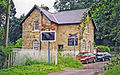
 / 53.03592; -1.56946 (Station Master's House)
Idridgehay former station geograph-3702486-by-Ben-Brooksbank.jpg
c. 1867The house was built by the Midland Railway for the station master of Idridgehay railway station. It is in gritstone with an oversailing Welsh slate roof. There are two storeys and a T-shaped plan. The doorway is in an angle, the ground floor windows in the main part have semicircular heads, and those in the upper floor have flat chamfered lintels. The west gable projects, and contains sash windows. [28] II
Sherbourne Mill
53°01′35″N1°33′58″W / 53.02650°N 1.56607°W / 53.02650; -1.56607 (Sherbourne Mill)
UndatedA former water-powered cornmill, it is in gritstone and red brick, and has a tile roof. There are two storeys and an overloft, a former wheelpit, plain doorways and windows, and a large curved buttress on the north side. The mill race is overgrown and blocked. [29] II

Related Research Articles

Dronfield is a civil parish in the North East Derbyshire district of Derbyshire, England. The parish contains 44 listed buildings that are recorded in the National Heritage List for England. Of these, one is listed at Grade I, the highest of the three grades, four are at Grade II*, the middle grade, and the others are at Grade II, the lowest grade. The parish contains the town of Dronfield, the district of Dronfield Woodhouse, the village of Coal Aston, and the surrounding area. Most of the listed buildings are houses, cottages and associated structures, farmhouses and farm buildings. The other listed buildings include churches, a churchyard cross, public houses, a former school, a milestone, a monument, and a bridge.

Bakewell is a civil parish in the Derbyshire Dales district of Derbyshire, England. The parish contains over 180 listed buildings that are recorded in the National Heritage List for England. Of these, six are listed at Grade I, the highest of the three grades, three are at Grade II*, the middle grade, and the others are at Grade II, the lowest grade. The parish contains the market town of Bakewell and the surrounding area. Most of the listed buildings are houses, cottages and associated structures, shops, offices, banks, and civic buildings. The other listed buildings include churches, two medieval cross bases in a churchyard, bridges, former almshouses, a guide stone, a milestone, former corn mills, public houses, a stile, a sheepwash enclosure, a former workhouse, now a hospital, with associated buildings, a railway station, a drinking fountain, a war memorial, and two telephone kiosks.

Bradbourne is a civil parish in the Derbyshire Dales district of Derbyshire, England. The parish contains 16 listed buildings that are recorded in the National Heritage List for England. Of these, one is listed at Grade I, the highest of the three grades, one is at Grade II*, the middle grade, and the others are at Grade II, the lowest grade. The parish contains the village of Bradbourne and the surrounding countryside. The listed buildings consist of houses, cottages and associated structures, farmhouses and farm buildings, a church and items in the churchyard, and a former watermill and associated buildings.

Brailsford is a civil parish in the Derbyshire Dales district of Derbyshire, England. The parish contains 35 listed buildings that are recorded in the National Heritage List for England. Of these, one is listed at Grade I, the highest of the three grades, and the others are at Grade II, the lowest grade. The parish contains the village of Brailsford and the hamlet of Ednaston, and the surrounding countryside. Most of the listed buildings are houses, cottages and associated structures, farmhouses and farm buildings. The other listed buildings include a church, a churchyard cross, a watermill, two boundary posts, two mileposts, a bridge, a school, and a well.

Brampton is a civil parish in the North East Derbyshire district of Derbyshire, England. The parish contains 37 listed buildings that are recorded in the National Heritage List for England. Of these, one is listed at Grade I, the highest of the three grades, three are at Grade II*, the middle grade, and the others are at Grade II, the lowest grade. The parish contains the villages of Cutthorpe, Old Brampton, and Wadshelf, and the surrounding countryside. Most of the listed buildings are houses and associated structures, farmhouses and farm buildings. The other listed buildings include a church, a chapel, and two guide posts.

Bretby is a civil parish in the South Derbyshire district of Derbyshire, England. The parish contains 13 listed buildings that are recorded in the National Heritage List for England. Of these, two are listed at Grade II*, the middle of the three grades, and the others are at Grade II, the lowest grade. The parish contains the village of Bretby and the surrounding countryside. The listed buildings include houses, cottages and associated structures, a farmhouse and farm buildings, a church, a former school, a former watermill, a bottle kiln and factory, a war memorial and village pump, and a telephone kiosk.

Crich is a civil parish in the Amber Valley district of Derbyshire, England. The parish contains 52 listed buildings that are recorded in the National Heritage List for England. Of these, one is listed at Grade I, the highest of the three grades, one is at Grade II*, the middle grade, and the others are at Grade II, the lowest grade. The parish contains the villages of Crich, Fritchley, Whatstandwell, and Wheatcroft, and the surrounding countryside. Most of the listed buildings are houses, cottages and associated structures, farmhouses and farm buildings. In the parish is the National Tramway Museum, and a number of structures that have been moved from other sites to the museum are listed. The other listed buildings include churches and chapels, a bridge over the Cromford Canal and a road bridge over the River Derwent, public houses, buildings associated with tramways, a milepost, a village cross, a memorial tower, and a village telephone kiosk.

Dale Abbey is a civil parish in the Erewash district of Derbyshire, England. The parish contains 20 listed buildings that are recorded in the National Heritage List for England. Of these, three are listed at Grade I, the highest of the three grades, one is at Grade II*, the middle grade, and the others are at Grade II, the lowest grade. The parish contains the village of Dale Abbey and the surrounding area. The village gets its name from the abbey of the same name, which is in ruins. The abbey ruins are listed, together with buildings in the village, including houses, farmhouses and farm buildings, and a church with an attached house. To the north of the village is a post mill, which is listed together with two associated buildings. To the west of the village is Locko Park, a country house, which is listed together with associated structures and items in its grounds.

Elton is a civil parish in the Derbyshire Dales district of Derbyshire, England. The parish contains 20 listed buildings that are recorded in the National Heritage List for England. All the listed buildings are designated at Grade II, the lowest of the three grades, which is applied to "buildings of national importance and special interest". The parish contains the village of Elton and the surrounding countryside. Most of the listed buildings are houses, cottages and associated structures, farmhouses and farm buildings. The other listed buildings consist of a church, and a public house and its associated stables.

Grindleford is a civil parish in the Derbyshire Dales district of Derbyshire, England. The parish contains 26 listed buildings that are recorded in the National Heritage List for England. Of these, one is listed at Grade I, the highest of the three grades, one is at Grade II*, the middle grade, and the others are at Grade II, the lowest grade. The parish contains the village of Grindleford and the surrounding countryside. Most of the listed buildings are houses, cottages and farmhouses and associated structures. The other listed buildings include a former gatehouse converted into a chapel, two bridges, a milestone and a milepost, a former cotton mill, a former toll house, and another chapel.

Hassop is a civil parish in the Derbyshire Dales district of Derbyshire, England. The parish contains 18 listed buildings that are recorded in the National Heritage List for England. Of these, one is listed at Grade I, the highest of the three grades, one is at Grade II*, the middle grade, and the others are at Grade II, the lowest grade. The parish contains the village of Hassop and the surrounding area. The Church of All Saints is listed at Grade I, and the other major building in the parish, Hassop Hall, is listed at Grade II*. Many of the other listed buildings are associated with the hall, or are in the grounds. The rest of the listed buildings include a house and a public house, both with associated structures, a farmhouse and outbuildings, and three mileposts.

Hathersage is a civil parish in the Derbyshire Dales district of Derbyshire, England. The parish contains 54 listed buildings that are recorded in the National Heritage List for England. Of these, one is listed at Grade I, the highest of the three grades, three are at Grade II*, the middle grade, and the others are at Grade II, the lowest grade. The parish, which is almost entirely rural, contains the village of Hathersage and the surrounding countryside. Most of the listed buildings are farmhouses and farm buildings, houses, cottages, and associated structures. The other listed buildings include two churches, a cross shaft in a churchyard, a presbytery and a vicarage, two bridges, former mills, a milepost, a former toll house, a railway viaduct, and a lamp column.

Hognaston is a civil parish in the Derbyshire Dales district of Derbyshire, England. The parish contains nine listed buildings that are recorded in the National Heritage List for England. Of these, one listed at Grade II*, the middle of the three grades, and the others are at Grade II, the lowest grade. The parish contains the village of Hognaston and the surrounding area. The listed buildings consist of houses, cottages, farmhouses, a church, and a telephone kiosk.

Holbrook is a civil parish in the Amber Valley district of Derbyshire, England. The parish contains 14 listed buildings that are recorded in the National Heritage List for England. Of these, one is listed at Grade II*, the middle of the three grades, and the others are at Grade II, the lowest grade. The parish contains the village of Holbrook, the hamlet of Coxbench, and the surrounding area. Most of the listed buildings are houses, cottages and associated structures, farmhouses and farm buildings. The other listed buildings include a church and associated structures, and two former stocking frame knitter's workshops.

Holmesfield is a civil parish in the North East Derbyshire district of Derbyshire, England. The parish contains 41 listed buildings that are recorded in the National Heritage List for England. Of these, five are listed at Grade II*, the middle of the three grades, and the others are at Grade II, the lowest grade. The parish contains the village of Holmesfield, the hamlet of Cartledge, and the surrounding countryside and moorland. Most of the listed buildings are houses, cottages and associated structures, farmhouses, and farm buildings. The other listed buildings include two medieval crosses, a cross dated 1619, a church, public houses, a former toll house, a milepost, and two milestones.

Holymoorside and Walton is a civil parish in the North East Derbyshire district of Derbyshire, England. The parish contains 18 listed buildings that are recorded in the National Heritage List for England. All the listed buildings are designated at Grade II, the lowest of the three grades, which is applied to "buildings of national importance and special interest". The parish contains the villages of Holymoorside and Walton, and the surrounding countryside. Most of the listed buildings are houses and associated structures, farmhouses and farm buildings, and the others are a milepost and a war memorial.

Hope is a civil parish in the High Peak district of Derbyshire, England. The parish contains 23 listed buildings that are recorded in the National Heritage List for England. Of these, one is listed at Grade I, the highest of the three grades, and the others are at Grade II, the lowest grade. The parish contains the village of Hope and the surrounding countryside. Most of the listed buildings are houses, farmhouses and farm buildings. The other listed buildings include a church and items in the churchyard, a cross converted into a guide post, a hotel, a former toll house, two mileposts, the engine house and chimney of a former lead mine, a school, and a war memorial.

Hopton is a civil parish in the Derbyshire Dales district of Derbyshire, England. The parish contains 21 listed buildings that are recorded in the National Heritage List for England. All the listed buildings are designated at Grade II, the lowest of the three grades, which is applied to "buildings of national importance and special interest". The parish contains the village of Hopton and the surrounding countryside. Most of the listed buildings are houses, cottages and associated structures, farmhouses and farm buildings. The other listed buildings include a guide post, a row of almshouses, the base of a former windmill, a well, and a railway bridge.

Killamarsh is a civil parish in the North East Derbyshire district of Derbyshire, England. The parish contains five listed buildings that are recorded in the National Heritage List for England. Of these, one is listed at Grade II*, the middle of the three grades, and the others are at Grade II, the lowest grade. The parish contains the town of Killamarsh and the surrounding area. All the listed buildings are in the town, and consist of a church and a cross in the churchyard, and a farmhouse and associated farm buildings.

Kirk Ireton is a civil parish in the Derbyshire Dales district of Derbyshire, England. The parish contains 27 listed buildings that are recorded in the National Heritage List for England. Of these, one is listed at Grade I, the highest of the three grades, one is at Grade II*, the middle grade, and the others are at Grade II, the lowest grade. The parish contains the village of Kirk Ireton and the surrounding countryside. Most of the listed buildings are houses, cottages and associated structures, farmhouses and farm buildings, and the others are churches and associated structures, and a public house.

References

Citations

Sources