Glenora is a residential neighbourhood in the city of Edmonton, Alberta, Canada, overlooking the North Saskatchewan River valley.

Woodcroft is a neighbourhood located in northwest Edmonton, Alberta, Canada. Surrounded by a mixture of residential neighbourhoods and light industrial subdivisions, it is bounded by 118 Avenue to the north, Groat Road to the east, 111 Avenue to the south, and 142 Street to the west. The neighbourhoods is home to Coronation Park and the Telus World of Science.
Stony Plain Road is an expressway and arterial road Edmonton, Alberta. Parkland Highway is an alternative route to the corresponding section of Highway 16 in Parkland County.
North Glenora is a residential neighbourhood in west Edmonton, Alberta, Canada. The neighbourhood is bounded on the north by 111 Avenue, on the south by 107 Avenue, on the east by Groat Road, and on the west by 142 Street. Groat Road provides access to locations on the south side, including the University of Alberta and Whyte Avenue.
St. Albert Trail is a major arterial road connecting the cities of Edmonton and St. Albert, Alberta. It is part of a 40-kilometre-long (25 mi) continuous roadway that runs through Sherwood Park, Edmonton, and St. Albert that includes Wye Road, Sherwood Park Freeway, Whyte Avenue, portions of University Avenue and Saskatchewan Drive, and Groat Road.

Groat Road is a major roadway in Edmonton, Alberta. It is named after Malcolm Groat, a former Hudson's Bay Company employee who settled in the present-day Groat Estates area in the 1880s. Groat Road is part of a 40-kilometre-long (25 mi) continuous roadway that runs through Sherwood Park, Edmonton, and St. Albert that includes Wye Road, Sherwood Park Freeway, Whyte Avenue, portions of University Avenue and Saskatchewan Drive, and St. Albert Trail. Groat Road functions as a grade-separated parkway between 87 Avenue and 111 Avenue.
Kingsway, sometimes called Kingsway Avenue, is an arterial road in central Edmonton, Alberta, Canada, that runs on a northwest to southeast path, cutting through the city's normal grid pattern. It skirts just to the south of Edmonton City Centre Airport, and connects to Kingsway Mall and the Royal Alexandra Hospital.
170 Street is a major arterial road in west Edmonton, Alberta. It serves residential, commercial and industrial areas. Gervais Road / Hebert Road is a major arterial road in south St. Albert, Alberta, Canada. It serves residential and commercial areas.

111 Street is a major arterial road in south Edmonton, Alberta, Canada. The south leg of the LRT runs between the northbound and southbound lanes north of 23 Avenue. It passes by Southgate Centre and the former location of Heritage Mall, now the location of the Century Park transit-oriented development.
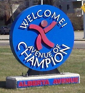
118 Avenue is the designated name of two major arterial roads in central Edmonton, Alberta, Canada, separated by the Edmonton City Centre Airport. The west side services both an industrial area, and a residential area, while the east 118 Avenue, originally Alberta Avenue, is one of the oldest streets in Edmonton outside the downtown core. The name was changed to 118 Avenue in 1914 with the adoption of the grid system. Historically, it was a route between the City of Edmonton in the west and the Town of Beverly in the east. It is also sometimes called the Avenue of Champions. When Beverly was still a separate community from Edmonton, the portion of Alberta Avenue in Beverly was the central business district. Beverly amalgamated with Edmonton on December 31, 1961. Following the amalgamation, Beverly's central business district went into a period of decline. The avenue boasts several major landmarks, including Northlands and the Coliseum.
97/98/101 Avenue and Baseline Road is a major arterial road in central Edmonton and north Sherwood Park, Alberta. It connects Downtown Edmonton with the mature residential neighborhoods on the city's eastern edge, as well as Refinery Row and Sherwood Park.
100 Avenue is a major arterial road in west Edmonton, Alberta, Canada.
University Avenue is a discontinuous street in west Edmonton, Alberta, Canada, partially an arterial road and partially a residential street. It was established in the 19th century along the south edge of a series of farm lots west of the yet-to-be-incorporated town of Strathcona, causing it to run parallel with the North Saskatchewan River to the north. The farm lots later became the University of Alberta campus, which was established in 1908. In the mid 20th century, University Avenue was permanently segmented as part of traffic calming measures, including disconnecting the eastern section with 114 Street, extending Joe Morris Park, and extending the grounds of Our Lady of Mount Carmel school.
97 Street is a major arterial road in north Edmonton, Alberta. It is used to take vehicles in and out of Downtown Edmonton to the city's northern suburban neighbourhoods and to the region's main military installation, CFB Edmonton. North of Yellowhead Trail, it is designated as part of Highway 28.

105 Street is an arterial road in Downtown Edmonton, Alberta, Canada. It starts across the North Saskatchewan River from Downtown, as one-way streets Walterdale Hill and Queen Elizabeth Park Road, which join and continue north on Walterdale Bridge. At 100 Avenue, 105 Street becomes a two-way street, and continues through Downtown past MacEwan University.
109 Street is an arterial road in central Edmonton, Alberta, Canada. It takes travelers out of Downtown to the south to Old Strathcona, and to the north to the Kingsway area. It passes several Edmonton landmarks including the Garneau Theatre, Alberta Legislature Building, MacEwan University, RCMP "K" Division Headquarters, and Kingsway Mall. It is a one-way street, southbound, from 97 Avenue to Saskatchewan Drive, to cross the North Saskatchewan River on the narrow High Level Bridge. Before Edmonton's amalgamation with Strathcona in 1912, the Edmonton portion was known as 9th Street while the Strathcona portion was known as 5th Street W. 109 Street between Whyte Avenue and Kingsway is part of the original alignment of Highway 2 through Edmonton, the designation was moved to Whitemud Drive in the 1980s.
Mayfield Road, 111 Avenue , and 112 Avenue is a major arterial road in north Edmonton, Alberta. It serves Edmonton's Northwest Industrial District, the former Town of Jasper Place, the inner city north Downtown Edmonton, and post-World War II Edmonton. Prior to the opening of Yellowhead Trail in the early 1980s, Highway 16 followed Mayfield Road and 111 Avenue between Stony Plain Road and 109 Street.
Fort Road is a discontinuous street in Edmonton, Alberta, Canada. Historically it was a major route in connecting Edmonton and Fort Saskatchewan. It was formed on the west side of the Canadian National Railway line that formerly connected the two cities, and crossed the North Saskatchewan River just south of the current Highway 15 bridge. As the city of Edmonton expanded its grid street system, and realigned the highway to Manning Drive, portions of Fort Road ceased to exist.
Mill Woods Road, together with 38 Avenue NW, is a ring road in the neighbourhood of Mill Woods, Edmonton, Alberta, Canada. Although Mill Woods is bisected by a number of numbered arterials, Mill Woods has utilized a newer form of residential and street design by building this inner neighbourhood ring, which acts as a collector for the curved and named residential streets.
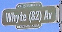
Whyte (82) Avenue is an arterial road in south-central Edmonton, Alberta, Canada. It became the main street of the City of Strathcona as it formed, and now runs through Old Strathcona. It was named in 1891 after Sir William Whyte, who was superintendent of the CPR's western division from 1886 to 1897 and was knighted by King George V in 1911. Whyte (82) Avenue is part of a 40-kilometre-long (25 mi) continuous roadway that runs through Sherwood Park, Edmonton, and St. Albert that includes Wye Road, Sherwood Park Freeway, portions of University Avenue and Saskatchewan Drive, Groat Road, and St. Albert Trail.


