The 1994 New Brunswick electoral redistribution was the first re-alignment of electoral districts in New Brunswick, Canada, since 1973. Under this redistribution, several districts were changed significantly due to considerable population shifts from the northern part of the province to the south. The total number of districts was reduced from 58 to 55. Due to considerable population shifts over the course of two decades, some ridings were merged, while others were split in two, and some were unchanged.
The draft recommendations of new districts was created by a royal commission appointed by PremierFrank McKenna in late 1991, which completed its report in 1993. The report was then referred to the provincial legislature which made changes, including the addition of a district and several boundary and name changes. The changes to districts were proclaimed into law in 1994.
Renamed from Memramcook to reflect the growth of Dieppe which is with its boundaries; lost small amount of territory to Tantramar while gaining approximately equal amount from Petitcodiac
Loses small amount of territory to the new Kent district while gaining an approximately equal amount from both Petitcodiac and the old Shediac district
The old district Shippagan-les-Isles loses some territory to the new Centre-Péninsule district and is renamed to reflect all of the large communities in the riding
The old York North district less some small amounts of territory, renamed to reflect the fact that the community within the riding has adopted the name "Mactaquac" based on its proximity to the Mactaquac Dam
This new riding, far smaller than the provincial average in population, consists of the three populated islands of the Bay of Fundy taking one each from old Charlotte County districts
An electoral district in Canada is a geographical constituency upon which Canada's representative democracy is based. It is officially known in Canadian French as a circonscription but frequently called a comté (county). In Canadian English it is also colloquially and more commonly known as a riding or constituency.
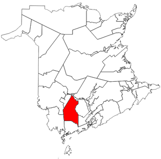
New Maryland-Sunbury was a provincial electoral district for the Legislative Assembly of New Brunswick, Canada.
Campbellton-Restigouche Centre was a provincial electoral district for the Legislative Assembly of New Brunswick, Canada.
Fredericton-Silverwood was a provincial electoral district for the Legislative Assembly of New Brunswick, Canada. It was first created using the name Fredericton South in the 1973 redrawing of electoral districts by splitting the two-member district of Fredericton and was first used in the 1974 general election. Its name was changed to Fredericton-Silverwood in the 2006 redrawing of electoral districts. The riding was split in two along Smythe Street in the 2013 redistribution, with half of the riding going to Fredericton South and half to Fredericton West-Hanwell.
Hampton-Kings was a provincial electoral district for the Legislative Assembly of New Brunswick, Canada. It was established in the 1994 electoral redistribution, in 2006 its boundaries were changed as its population was above the allowable reasonable population and its name was changed from Hampton-Belleisle to Hampton-Kings.
Victoria-Tobique was a provincial electoral district for the Legislative Assembly of New Brunswick, Canada. This riding was created in the 1973 redistribution when New Brunswick moved to single member districts. It had previously been part of the Victoria district which returned two members.
Bathurst is a former and newly upcoming provincial electoral district for the Legislative Assembly of New Brunswick, Canada.
Centre-Péninsule-Saint-Sauveur is a provincial electoral district for the Legislative Assembly of New Brunswick, Canada. It was created in the 1994 redistribution of districts as Centre-Péninsule; its boundaries were adjusted in the 2006 redistribution in order to rebalance the population of districts on the Acadian Peninsula. Though the Electoral Boundaries Commission did not recommend a name change, the Legislative Assembly later decided to change the name by adding Saint-Sauveur to its name.
Saint John East is a provincial electoral district for the Legislative Assembly of New Brunswick, Canada.
Tantramar is a provincial electoral district for the Legislative Assembly of New Brunswick, Canada.
Restigouche West is a provincial electoral district for the Legislative Assembly of New Brunswick, Canada. It was used from 1974 through 2003, when it was split between the ridings of Restigouche-La-Vallée and Campbellton-Restigouche Centre. The riding was re-established in the 2013 electoral redistribution from parts of Dalhousie-Restigouche East, Restigouche-La-Vallée and Campbellton-Restigouche Centre and will be contested again beginning in the 2014 general election.
Kent North is a provincial electoral district for the Legislative Assembly of New Brunswick, Canada.
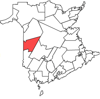
Carleton was a provincial electoral district for the Legislative Assembly of New Brunswick, Canada.
The 2006 New Brunswick electoral redistribution was undertaken as a result of legislation introduced by Bernard Lord, the Premier of New Brunswick, Canada, on June 9, 2005. The legislation establishes a statutory requirement for redistribution of electoral districts after every decennial Canadian census.
Fredericton-Nashwaaksis was a provincial electoral district for the Legislative Assembly of New Brunswick, Canada. It was first created in the 2006 redrawing of electoral districts and was first used in the general election later that year.
In Australia, a redistribution is the process of redrawing the boundaries of electoral divisions for the House of Representatives arising from changes in population and changes in the number of representatives. There is no redistribution for the Senate as each State constitutes a division, though with multiple members. The Australian Electoral Commission (AEC), an independent statutory authority, oversees the apportionment and redistribution process for federal divisions, taking into account a number of factors. Politicians, political parties and the public may make submissions to the AEC on proposed new boundaries, but any interference with their deliberations is considered a serious offence.
The 2013 New Brunswick electoral redistribution was undertaken through the process set out in the Electoral Boundaries and Representation Act of New Brunswick, Canada. The legislation establishes a statutory requirement for redistribution of electoral districts after every second New Brunswick general election.
The federal electoral redistribution of 2012 was a redistribution of electoral districts ("ridings") in Canada following the results of the 2011 Canadian census. As a result of amendments to the Constitution Act, 1867, the number of seats in the House of Commons of Canada increased from 308 to 338. The previous electoral redistribution was in 2003.
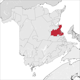
Miramichi—Grand Lake is a federal electoral district in New Brunswick.
This page is based on this Wikipedia article Text is available under the CC BY-SA 4.0 license; additional terms may apply. Images, videos and audio are available under their respective licenses.