
The 2002 North American Drought was an exceptional and damaging drought which impacted the Western United States, Midwestern United States and the Mountain States, as well as the Eastern Seaboard.
The 2002 North American Drought was an exceptional and damaging drought which impacted the Western United States, Midwestern United States and the Mountain States, as well as the Eastern Seaboard.
The drought of 2002 began around spring and spread over numerous states, including Nebraska, Iowa, Colorado, Wyoming and Utah. [1] [2] Denver was forced to impose water restrictions for the first time in over 20 years. The drought of 2002 had a negative impact in many states. [3] [4]
As usually happens during dry spells in the eastern United States, the 2002 drought was caused by a westward extension of the semi-permanent Bermuda High, which resulted in a continuous flow of hot south-southwesterly air north and caused the storm track to be pushed well off to the west. The density of the Bermuda High also kept hot air at ground level and prevented the formation of convective clouds. The Midwestern states and Mississippi Valley for contrast had a quite wet summer as most rainfall from frontal systems fell in that region. This was much the same weather pattern as the earlier 1999 North American drought, but in 2002 a secondary and unusual event happened when a high pressure system formed over the Gulf of Mexico, a rare occurrence during the summer months. This further blocked the flow of Gulf moisture northward. Precipitation deficits were greatest from New Jersey southward to Georgia and less so in New York and New England with the Great Lakes states and the Mississippi watershed being unusually wet. A shift to an El Nino pattern in fall 2002 brought about wetter, cooler conditions for much of 2003-04 which erased the precipitation deficits from the 1998-02 drought events. [5]
The drought of 2002 also ravaged certain parts of Canada, particularly Alberta, Manitoba and Saskatchewan. [6]
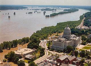
The Great Flood of 1993 was a flood that occurred in the Midwestern United States, along the Mississippi and Missouri rivers and their tributaries, from April to October 1993.

Blocks in meteorology are large-scale patterns in the atmospheric pressure field that are nearly stationary, effectively "blocking" or redirecting migratory cyclones. They are also known as blocking highs or blocking anticyclones. These blocks can remain in place for several days or even weeks, causing the areas affected by them to have the same kind of weather for an extended period of time. In the Northern Hemisphere, extended blocking occurs most frequently in the spring over the eastern Pacific and Atlantic Oceans. Whilst these events are linked to the occurrence of extreme weather events such as heat waves, particularly the onset and decay of these events is still not well captured in numerical weather forecasts and remains an open area of research.
The 1991 Halloween blizzard was a powerful storm that caused a period of heavy snowfall and ice accumulation, which affected parts of the Upper Midwest of the United States, from October 31 to November 4, 1991. Over the last week of October 1991, a large storm system over the Atlantic Ocean blocked most of the weather patterns over the eastern half of the United States, and in turn, moisture from the Gulf of Mexico was funneled straight northward over the affected region. By the time the precipitation stopped falling, many cities in the eastern half of Minnesota and northwestern Wisconsin had witnessed record early-season snowfall accumulations, while parts of southern Minnesota and northern Iowa were crippled by a large ice storm. Arctic air that was pulled southward behind the storm had combined with the heavy snow pack to produce many record low temperatures. Between the blizzard and the ice storm, 22 people were killed and over 100 were injured.

Minnesota has a humid continental climate, with hot summers and cold winters. Minnesota's location in the Upper Midwest allows it to experience some of the widest variety of weather in the United States, with each of the four seasons having its own distinct characteristics. The area near Lake Superior in the Minnesota Arrowhead region experiences weather unique from the rest of the state. The moderating effect of Lake Superior keeps the surrounding area relatively cooler in the summer and warmer in the winter, giving that region a smaller yearly temperature variation. On the Köppen climate classification, much of the southern third of Minnesota—roughly from the Twin Cities region southward—falls in the hot summer zone (Dfa), and the northern two-thirds of Minnesota falls in the warm summer zone (Dfb).

The characteristics of United States rainfall climatology differ significantly across the United States and those under United States sovereignty. Summer and early fall bring brief, but frequent thundershowers and tropical cyclones which create a wet summer and drier winter in the eastern Gulf and lower East Coast. During the winter, and spring, Pacific storm systems bring Hawaii and the western United States most of their precipitation. Low pressure systems moving up the East Coast and through the Great Lakes, bring cold season precipitation to from the Midwest to New England, as well as Great Salt Lake. The snow to liquid ratio across the contiguous United States averages 13:1, meaning 13 inches (330 mm) of snow melts down to 1 inch (25 mm) of water.

North Dakota's climate is typical of a continental climate with cold winters and warm-hot summers. The state's location in the Upper Midwest allows it to experience some of the widest variety of weather in the United States, and each of the four seasons has its own distinct characteristics. The eastern half of the state has a humid continental climate with warm to hot, somewhat humid summers and cold, windy winters, while the western half has a semi-arid climate with less precipitation and less humidity but similar temperature profiles. The areas east of the Missouri River get slightly colder winters, while those west of the stream get higher summer daytime temperatures. In general, the diurnal temperature difference is prone to be more significant in the west due to higher elevation and less humidity.

The climate of the United States varies due to changes in latitude, and a range of geographic features, including mountains and deserts. Generally, on the mainland, the climate of the U.S. becomes warmer the farther south one travels, and drier the farther west, until one reaches the West Coast.

The Geography of Oklahoma encompasses terrain and ecosystems ranging from arid plains to subtropical forests and mountains. Oklahoma contains 10 distinct ecological regions, more per square mile than in any other state by a wide margin. It is situated in the Great Plains and U.S. Interior Highlands region near the geographical center of the 48 contiguous states. Usually considered part of the South Central United States, Oklahoma is bounded on the east by Arkansas and Missouri, on the north by Kansas, on the northwest by Colorado, on the far west by New Mexico, and on the south and near-west by Texas.

The El Niño–Southern Oscillation affects the location of the jet stream, which alters rainfall patterns across the West, Midwest, the Southeast, and throughout the tropics. The shift in the jet stream also leads to shifts in the occurrence of severe weather, and the number of tropical cyclones expected within the tropics in the Atlantic and Pacific oceans affected by changes in the ocean temperature and the subtropical jet stream. The winter will have a negative phase according to the Arctic oscillation (AO).

The United States' contiguous western and especially southwestern region has experienced widespread drought since about year 2000. Below normal precipitation leads to drought, and is caused by an above average persistence of high pressure over the affected area. Changes in the track of extratropical cyclones, which can occur during climate cycles such as the El Niño-Southern Oscillation, or ENSO, as well as the North Atlantic Oscillation, Pacific Decadal Oscillation, and Atlantic multidecadal oscillation, modulate which areas are more prone to drought. Increased drought frequency and severity is also expected to be one of the effects of global warming.

The North American monsoon, variously known as the Southwest monsoon, the Mexican monsoon, the New Mexican monsoon, or the Arizona monsoon is a term for a pattern of pronounced increase in thunderstorms and rainfall over large areas of the southwestern United States and northwestern Mexico.

A humid subtropical climate is a temperate climate type characterized by hot and humid summers, and cool to mild winters. These climates normally lie on the southeast side of all continents, generally between latitudes 25° and 40° and are located poleward from adjacent tropical climates, and equatorward from either humid continental or oceanic climates. It is also known as warm temperate climate in some climate classifications.

The climate of Los Angeles is mild to hot year-round, and mostly dry. It is classified as borderline Mediterranean and semi-arid. The city is characterized by seasonal changes in rainfall—with a dry summer and a winter rainy season. Under the Köppen climate classification, the coastal areas are classified as BSh and Csb, while the inland areas are classified as BSh and Csa.

The Tampa Bay area has a humid subtropical climate, closely bordering a tropical climate near the waterfront areas. There are two basic seasons in the Tampa Bay area, a hot and wet season from May through October, and a mild and dry season from November through April.

The 1988–1990 North American drought ranks among the worst episodes of drought in the United States. This multi-year drought began in most areas in 1988 and continued into 1989 and 1990. The drought caused $60 billion in damage in United States dollars, adjusting for inflation. The drought occasioned some of the worst blowing-dust events since 1977 or the 1930s in many locations in the Midwestern United States, including a protracted dust storm, which closed schools in South Dakota in late February 1988. During the spring, several weather stations set records for the lowest monthly total precipitation and the longest interval between measurable precipitation, for example, 55 days in a row without precipitation in Milwaukee. During the summer, two record-setting heatwaves developed, similar to those of 1934 and 1936. The concurrent heat waves killed 4,800 to 17,000 people in the United States. During the summer of 1988, the drought led to many wildfires in forested western North America, including the Yellowstone fires of 1988.
The 2011 North American heat wave was a deadly summer 2011 heat wave that affected the Southern Plains, the Midwestern United States, Eastern Canada, the Northeastern United States, and much of the Eastern Seaboard, and had Heat index/Humidex readings reaching upwards of 131 °F (55 °C). On a national basis, the heat wave was the hottest in 75 years.

The 2011–12 North American winter by and large saw above normal average temperatures across the continent, with the Contiguous United States encountering its fourth-warmest winter on record, along with an unusually low number of significant winter precipitation events. The primary outlier was Alaska, parts of which experienced their coldest January on record.

The 2006–08 Southeastern United States drought was a crippling drought that struck the southeast of the U.S. Several reasons, including an unusually strong Bermuda high pressure and La Niña in the eastern Pacific Ocean were responsible for the drought. 2007 was particularly dry across the region, with rivers and lakes dropping to record-low levels.

Climate change in Colorado encompasses the effects of climate change, attributed to man-made increases in atmospheric carbon dioxide, in the U.S. state of Colorado.

The 2017–18 North American winter saw weather patterns across North America that were very active, erratic, and protracted, especially near the end of the season, resulting in widespread snow and cold across the continent during the winter. Significant events included rare snowfall in the South, an outbreak of frigid temperatures that affected the United States during the final week of 2017 and early weeks of January, and a series of strong nor'easters that affected the Northeastern United States during the month of March. In addition, flooding also took place during the month of February in the Central United States. Finally the winter came to a conclusion with a powerful storm system that caused a tornado outbreak and blizzard in mid-April. The most intense event, however, was an extremely powerful cyclonic blizzard that impacted the Northeastern United States in the first week of 2018. Similar to the previous winter, a La Niña was expected to influence the winter weather across North America.
| | This article about or related to natural disasters is a stub. You can help Wikipedia by expanding it. |