Related Research Articles

Vietnam is divided into 63 first-level subdivisions, comprising fifty-seven provinces and six municipalities under the command of the central government. Municipalities are the highest-ranked cities in Vietnam. Municipalities are centrally-controlled cities and have special status equal to that of the provinces.
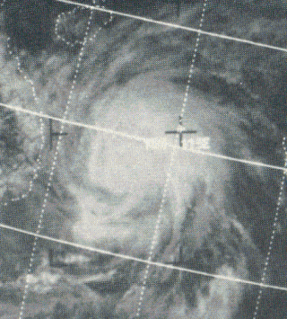
Typhoon Hester of October 1971 was regarded as one of the most destructive storms to strike Vietnam since 1944. Developing as a tropical depression on October 18 near Palau, Hester gradually intensified as it moved westward towards the Philippines. Across the Philippines, Hester was responsible for six deaths and ₱5 million in damage. After passing over Mindanao and the Visayas as a tropical storm between October 20 and 21, the storm intensified into a typhoon before striking Palawan. Once over the South China Sea, Hester further strengthened and ultimately attained peak winds of 165 km/h (105 mph). On October 23, the storm made landfall near Huế, South Vietnam. Once onshore, Hester rapidly weakened and dissipated on October 24 over Laos.

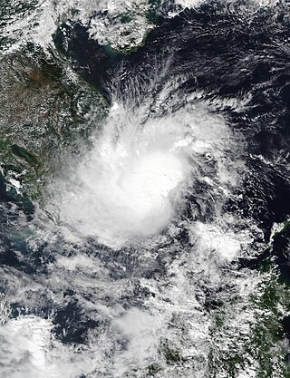
Tropical Storm Toraji was a short-lived and minimal tropical cyclone that brought inundating rainfall to areas of Southeast Asia in July 2007. The name Toraji was contributed to the western Pacific typhoon naming list by North Korea and stands for a broad bell flower. The third named storm of the annual typhoon season, Toraji developed from an area of disturbed weather within the South China Sea on July 4. As a result of its northwesterly track, the tropical depression moved over Hainan shortly after tropical cyclogenesis. Upon its emergence into the Gulf of Tonkin on July 5, Toraji quickly intensified into a tropical storm with winds of 65 km/h (40 mph); this would be the tropical cyclone's peak intensity for its entire duration. However, the JMA indicated that tropical storm intensity had been reached a day earlier. On the evening of July 5, Toraji made its final landfall on Dongxing, Guangxi before rapidly deteriorating inland and degenerating into a remnant low-pressure area by the following day.

Typhoon Wutip, known in the Philippines as Tropical Storm Paolo, was a Category 3 major typhoon that affected Vietnam, Laos, and Thailand. The nineteenth named storm and the fifth typhoon of the 2013 Pacific typhoon season. Wutip formed off the coast of Luzon on September 27, 2013. Being inside PAR, PAGASA named the disturbance Paolo which replaced the name Pepeng. JTWC later gave the identifier Tropical Depression 20W. Moving west-southwestward, the system intensified into a tropical storm, assigning the name Wutip. Wutip reached its peak intensity of a Category-3 major typhoon. On September 30, the storm made landfall on the provinces from Ha Tinh to Thua Thien Hue province of Vietnam, including Quang Binh the center of the storm.

The Six Provinces of Southern Vietnam is a historical name for the region of Southern Vietnam, which is referred to in French as Basse-Cochinchine. The region was politically defined and established after the inauguration of the Nguyễn dynasty, and called by this name from 1832, when Emperor Minh Mạng introduced administrative reforms, to 1867, which culminated in the eight-year French campaign to conquer the Six Provinces.
The November 2016 Vietnam tropical depression caused heavy flooding throughout central and southern Vietnam. Forming out from a low-pressure system on November 3, the Japan Meteorological Agency (JMA) began monitoring it as a tropical depression. With favorable conditions aloft and an increase of organization, the JMA predicted that it had a chance of becoming a tropical storm while the Joint Typhoon Warning Center (JTWC) in the same time issued a Tropical Cyclone Formation Alert on November 4. Due to its proximity to land and a circulation displaced from the deep convection, both the JMA and the JTWC canceled their warnings as it made landfall over in Southern Vietnam. The system continued moving westward over land and the JMA stopped tracking on the system on November 6.

Severe Tropical Storm Aere, known in the Philippines as Tropical Storm Julian, was a long-lived tropical cyclone that struck Central Vietnam in October 2016. The nineteenth named storm of the annual typhoon season, Aere formed on October 4, 2016 as a tropical depression to the east of Luzon, Philippines shortly after the JMA had started tracking Songda. On the next day, the system had become a tropical storm and it moved into South China Sea. During October 7, it intensified into a severe tropical storm and reached peak intensity with 10-minute winds of 110 km/h (70 mph). Shortly thereafter, due to remaining in almost the same area for hours, Aere began to weaken to a tropical storm, and on October 10, it weakened to a tropical depression, before weakening to a low-pressure area late on October 11. On October 13, Aere re-generated into a tropical depression and it made landfall in Huế, Vietnam late that day. The system moved towards Laos and Thailand before it fully dissipated on October 14.

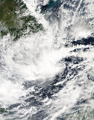
Tropical Storm Sonca was a weak tropical cyclone that impacted Southeast Asia during the end of July 2017. As the 10th named storm of the 2017 Pacific typhoon season, Tropical Storm Sonca formed south of Hong Kong, after drifting westward for multiple days, the storm intensified into a tropical storm, receiving the name Sonca. The storm later affected Hainan, reaching its peak intensity. On July 25, the storm made landfall over the Quảng Trị province, then dissipated.

Typhoon Doksuri, known in the Philippines as Tropical Storm Maring, was a strong Category 2 typhoon that mostly impacted the Philippines and Vietnam during mid-September 2017. Forming as the nineteenth named storm of the season, Doksuri developed as a weak tropical depression over to the east of Visayas on September 10.

The October 2017 Vietnam tropical depression, also known officially by its designation as Tropical Depression 23W, was a weak but deadly system that brought torrential rainfall and extreme flooding over northern and central Vietnam in October 2017. The depression formed on October 7, located to the northwest of Luzon, Philippines. The system moved in a general westward direction as it steadily intensified. Despite being forecast to strengthen into a tropical storm, 23W failed to reach this intensity, due to lack of organization as it made landfall in Hà Tĩnh Province on October 10.

Typhoon Damrey, known in the Philippines as Severe Tropical Storm Ramil, was a strong tropical cyclone that affected the Philippines and Vietnam during early November 2017. Damrey first originated as a tropical depression over the Philippine archipelago of Visayas on October 31. Emerging into the South China Sea a few days later, the system strengthened into the second deadliest and twenty-third named storm of the 2017 Pacific typhoon season. Rapidly intensifying, Damrey became the season's tenth typhoon on November 3, reaching its peak intensity as a Category 2 on the same day. Damrey made landfall over Khánh Hoà, Vietnam on November 4 and began to rapidly weaken, fully dissipating on November 5.

Tropical Storm Ewiniar was a tropical cyclone in early June 2018 that brought prolonged heavy rains to Vietnam and South China, causing damaging floods and landslides. The fourth named storm of the 2018 Pacific typhoon season, Ewiniar developed as a tropical depression just east of Vietnam on June 2. The system moved generally northwards over the South China Sea, before intensifying into a tropical storm near the Qiongzhou Strait on June 5. Ewiniar proceeded to stall over the region as steering currents collapsed, making landfall over the Leizhou Peninsula and later over northern Hainan. Ewiniar accelerated to the northeast on June 7 and moved back over open sea, allowing it to strengthen slightly and reach peak intensity with maximum sustained winds of 75 km/h (47 mph) and a central pressure of 998 hPa. The storm made landfall in eastern Guangdong shortly thereafter and weakened into a tropical depression on June 8. The system ultimately dissipated east of Taiwan on June 11.
On 23 June, floods started across the northern provinces of Vietnam. The flood waters have receded from the northern mountainous provinces of Lai Chau, Ha Giang and Lao Cai while several towns and villages were inaccessible. 23 people were confirmed dead in the floods: in Lai Chau 16 were killed, 5 in Ha Giang Province while two others in other provinces. An estimated VND530 billion of damage was recorded in Lao Cai, Ha Giang and Lai Chau and over 80 houses had been destroyed and over 700 hectares of rice fields damaged.

Tropical Storm Son-Tinh, known in the Philippines as Tropical Storm Henry, was a weak but very deadly tropical cyclone that devastated Vietnam and Laos in July 2018. Son-Tinh originated from an area of low pressure over the Philippine Sea on July 15, 2018. Moving quickly westwards, Son-Tinh strengthened to the ninth tropical storm of the annual typhoon season on July 17. Intensifying only slightly while crossing the South China Sea, Son-Tinh made its first landfall over Hainan Island on July 18. After emerging into the Gulf of Tonkin, Son-Tinh restrengthened before making its second landfall as a tropical storm in Northern Vietnam on July 19. Once inland, Son-Tinh weakened into a low pressure area as it slowed and made a clockwise loop. The remnants of Son-Tinh then emerged back over water and regenerated into a tropical depression late on July 21.
Vietnam was hit by several floods in 2019.
Tropical Storm Toraji was a weak, short-lived system that impacted Vietnam in November 2018. Forming as the twenty-seventh named storm of the 2018 Pacific typhoon season, Toraji developed as a tropical depression to the southeast of Vietnam on November 16. Quickly organising, the system strengthened into a tropical storm the next day. Toraji rapidly weakened thereafter early on November 18, when the storm made landfall over southeastern Vietnam, later dissipating. The storm's remnants moved into the Gulf of Thailand when Toraji re-organised back into a tropical depression on November 20. However Toraji quickly deteriorated on the same day as it moved closer to the Malay Peninsula.

The 2020 Central Vietnam floods were a series of floods in Central Vietnam, which also affected some areas in Cambodia and Laos in October and early November 2020. The floods focused heavily in several provinces including Thừa Thiên Huế, Hà Tĩnh, Quảng Bình, Quảng Trị, and Quảng Ngãi. The floods were mainly caused by the seasonal monsoon, though enhanced by numerous tropical cyclones.

Vietnam is a southeast Asian country, and is the easternmost country of mainland Southeast Asia. It borders the South China Sea, hence, seeing the increased likeliness of tropical cyclones. Tropical cyclones in this area are considered to be part of the Northwest Pacific basin, and therefore, storms here are considered as typhoons.

Typhoon Yagi, known in Vietnam as Typhoon No. 3 of 2024, originated from a tropical depression northwest of Palau, entered the South China Sea, and rapidly intensified into a super typhoon. By 7 September, Yagi made landfall in Vietnam's Haiphong City and Quảng Ninh Province, causing catastrophic damage to lives and property. The typhoon and post-typhoon severe weather brought strong winds and heavy rainfall to the entirety of northern Vietnam, triggering a series of adverse effects such as flash floods and landslides in mountainous areas. It also resulted in historic floods in northern Vietnam in early September 2024.
References
- ↑ Flood deaths in northern Vietnam increase to 22
- ↑ Floods, landslides kill 22 residents in northern Vietnam
- ↑ Floods, landslides in northern Vietnam kill 23, leave 10 missing
- ↑ Vietnam flood death toll rises to 27, more rain forecast
- ↑ "Vietnam flooding kills 3". Archived from the original on 2018-08-03. Retrieved 2018-12-11.
- ↑ Landslides kill 6, leave 5 missing in northern Vietnam
- ↑ 14 killed, 4 missing in Vietnam floods, says country's natural disaster prevention and control agency
- ↑ "Tìm thấy thi thể thanh niên bị nước lũ cuốn trôi trong bão số 9". laodong.vn. 2018-11-28. Retrieved 2018-12-04.
- ↑ "TP.HCM: Đang tìm kiếm một người bị nước cuốn xuống kênh Đen". infonet.vn. 2018-11-26. Retrieved 2018-11-29.
- ↑ "Global Catastrophe Recap November 2018" (PDF). December 6, 2018. Archived from the original (PDF) on December 9, 2018. Retrieved December 7, 2018.