Related Research Articles

The 1970 North Indian Ocean cyclone season had no bounds, but tropical cyclones in the North Indian Ocean tend to form between April and December, with peaks in May and November. The 1970 season saw a total of seven cyclonic storms, of which three developed into severe cyclonic storms. The Bay of Bengal was more active than the Arabian Sea during 1970, with all of the three severe cyclonic storms in the season forming there. Unusually, none of the storms in the Arabian Sea made landfall this year. The most significant storm of the season was the Bhola cyclone, which formed in the Bay of Bengal and hit Bangladesh on November 12. The storm killed at least 500,000, making it the deadliest tropical cyclone in recorded history. The season was also the deadliest tropical cyclone season globally, with 500,805 fatalities, mostly due to the aforementioned Bhola cyclone.

The 2007 South Asian floods were a series of floods in India, Pakistan, Bhutan, Nepal and Bangladesh. News Agencies, citing the Indian and Bangladeshi governments, place the death toll in excess of 2,000. By 3 August, approximately 20 million had been affected and by 10 August some 30 million people in India, Bangladesh and Nepal had been affected by flooding.
The 2008 Indian floods were a series of floods in various states of India during the 2008 monsoon season. The floods mostly affected the western regions of Maharashtra state and Andhra Pradesh as well as northern Bihar. In India, the monsoon season generally lasts from June to September.
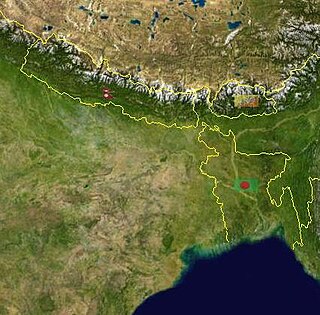
Bihar is located in the eastern region of India, between latitudes 24°20'10"N and 27°31'15"N and longitudes 83°19'50"E and 88°17'40"E. It is an entirely land–locked state, in a subtropical region of the temperate zone. Bihar lies between the humid West Bengal in the east and the sub humid Uttar Pradesh in the west, which provides it with a transitional position in respect of climate, economy and culture. It is bounded by Nepal in the north and by Jharkhand in the south. Bihar plain is divided into two unequal halves by the river Ganges which flows through the middle from west to east. Bihar's land has average elevation above sea level of 173 feet.
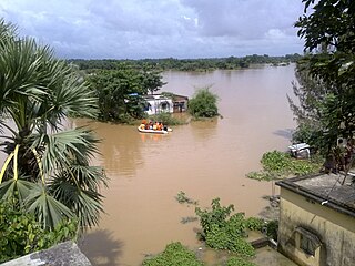
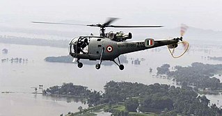
The 2007 Bihar flood occurred in August 2007 in the east Indian state of Bihar. It was described by the United Nations as the worst flood in the living memory of Bihar. Although annual floods are common in Bihar, heavier than usual rainfall during the monsoon season that year led to increasing water levels. By 3 August, the estimated death toll was 41 people, and 48 schoolgirls were marooned in a school in the Darbhanga district. By 8 August, the flooding had impacted an estimated 10 million people in Bihar. Army helicopters delivered food packets to residents, and 180 relief camps were established. By 10 August, aid workers in Bihar reported a dramatic increase in people with diarrhea and by 11 August, flood-related deaths were still occurring. The total number of deaths recorded in the 2007 Bihar floods was more than 1,3050, the highest death toll in the state since the 1987 Bihar floods, in which more than 2,500 deaths were reported.
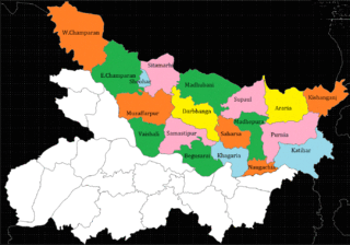
Bihar is recognized as India's most flood-prone state, with approximately 76% of the population in North Bihar living under the persistent threat of severe flooding. Bihar makes up 16.5% of India's flood-affected area and contains 22.1% of India's flood-affected population. About 73.06% of Bihar's geographical area, 68,800 square kilometres (26,600 sq mi) out of 94,160 square kilometres (36,360 sq mi), is affected. Each year, floods kill many and damage livestock and other assets worth millions. In total, floods have claimed 9,500 lives since the government started publishing figures in 1979. North Bihar districts are vulnerable to at least five major flood-causing rivers during monsoon – the Mahananda, Koshi, Bagmati, Burhi Gandak, and Gandak rivers – which originate in Nepal. Some South Bihar districts have also become vulnerable to floods, from the Son, Punpun, and Phalgu rivers. The 2013 flood affected over 5.9 million people in 3,768 villages in 20 districts in the state. The 2017 flood affected 19 districts in North Bihar, killing 514 people and affecting over 17 million.
The 2009 India floods affected various states of India in July 2009, killing at least 36 people in Orissa and 13 in Kerala. The most affected states were Karnataka, Orissa, Kerala, Gujarat and North-East Indian states.
North Bihar is a term used for the region of Bihar, India, which lies north of the Ganga river.
This is a list of notable recorded floods that have occurred in India. Floods are the most common natural disaster in India. The heaviest southwest, the Brahmaputra, and other rivers to distend their banks, often flooding surrounding areas.
Following heavy rain in July 2017, the Indian state of Gujarat was affected by severe flooding. The floods were reported to have caused total 224 deaths between 1 June and 31 July 2017. 16 people had died in neighbouring Rajasthan state by 31 July.

2017 Bihar floods affected 19 districts of North Bihar causing death of 514 people. 2,371 panchayats under 187 blocks of 19 districts of Northern Bihar have been affected in the flood. Around 1.71 crore people were hit by the floods. Over 8.5 lakhs of people have lost their homes, with Araria district alone accounting for 2.2 lakh homeless people. 2017 Flood has broken 9-Year record of deaths In Bihar. Bihar is India's most flood-prone State, with 76% of the population in the North Bihar living under the recurring threat of flood devastation. Devastating flood was caused due to excess heavy rainfall in monsoon season.
Widespread monsoon flooding occurred in the South Asian countries of Afghanistan, Bangladesh, India, Nepal and Pakistan from July through September 2017. More than 45 million people were affected by the floods, including 16 million children.
The Brahmaputra floods refers to a catastrophic flood event that occurred in 2012 along the Brahmaputra River and its tributaries, as well as in subsequent years.
The 2019 Indian floods were a series of floods that affected over thirteen states in late July and early August 2019, due to excessive rains. At least 200 people died and about a million people were displaced. Karnataka and Maharashtra were the most severely affected states. People died but many were rescued with the help of the Indian Navy.
On 1 August 2019, first week, due to heavy rainfall in the Monsoon season, severe flood affected the southern Indian State of Karnataka. As a security measure in the prevailing situation of heavy rains, India Meteorological Department issued Red alert to several regions of coastal and malnad regions of Karnataka state.

The 1993 India floods was a deadly flood caused by several days long heavy monsoon rains and severe weather that occurred in July 1993 across eight states in the north of the country. Severe floods left 530 fatalities and millions people went homeless, including from Haryana. Punjab with 350 deaths was the most affected state where "1.2 million acres of crops" were extensively damaged, mostly from Patiala, north-western region of the state. Flash floods swept away major railway tracks, roads, and bridges, leading to disrupt the communications between the northeastern states and the rest of the country. Initial reports cited one hundred deaths in Gujarat.
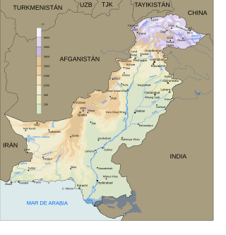
In 2016 Pakistan experienced higher rainfall than normal (10-20%), especially in the pre-monsoon season. Heavy monsoon rains are common in the region. This led to multiple periods of flooding, landslides, and damage particularly in Northern Pakistan. The Swat River overflowed and multiple landslides occurred around Pakistan including in Khyber Pakhtunkhwa, Gilgit-Baltistan, Azad Jammu, and Kashmir.

Beginning in May 2022, deadly floods hit northeastern India and Bangladesh. Over 9 million people in both countries have been affected, and around 300 people were killed.
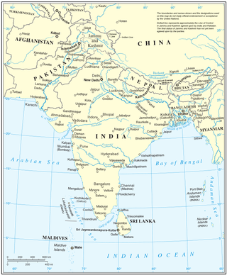
From January to October 2022, excessive rainfall and widespread monsoon flooding occurred in the South Asian countries of Afghanistan, Bangladesh, India, Nepal, Pakistan, and Sri Lanka. It has become the region's deadliest floods since 2020, with over 4,700 people dead.

Heavy rainfall during the 2024 monsoon season resulted in severe flooding and landslides across several regions of India. Rainfall caused significant flooding first in Assam State and later end of August also in Gujarat, India.
References
- ↑ "Flood situation in Assam, Bihar grim; death toll reaches 209". Moneycontrol. Retrieved 2019-07-29.
- 1 2 "Over 2.5 million affected due to floods in Bihar". India Today. July 16, 2019. Retrieved 2019-07-29.
- ↑ "Floods continue to pile agony on people of Bihar, Assam". www.livemint.com. 2019-07-19. Retrieved 2019-07-29.
- ↑ "Death toll in Assam, Bihar floods reaches 197; around 1.24 crore people affected". businesstoday.in. Retrieved 2019-07-29.
- 1 2 3 "Bihar floods death toll climbs to 130 - India News". 2019-08-04. Archived from the original on 2019-08-04. Retrieved 2019-08-04.
- 1 2 3 "Flood/Heavy Rain Fall Report" (PDF). Bihar Disaster Management Department, Government of Bihar (published 4 August 2019). 2019-08-04. Archived from the original (PDF) on 2019-08-04. Retrieved 2019-08-04.
- ↑ "Floods in Bihar, Assam claim 209 live; IAF deploys two helicopters for relief work, 19 NDRF teams assist in rescue operation". Firstpost. Retrieved 2019-07-29.
- ↑ "Worst monsoon in 25 years kills 148 across India, floods ravage Patna".
- ↑ "पटना बाढ़ 2019: छह महीने बाद ऐक्शन, बुडको के पूर्व एमडी समेत तीन अधिकारी सस्पेंड".
- ↑ "Patna Floods Recede; Death Toll at Least 17".