Related Research Articles

Year 602 (DCII) was a common year starting on Monday of the Julian calendar. The denomination 602 for this year has been used since the early medieval period, when the Anno Domini calendar era became the prevalent method in Europe for naming years.
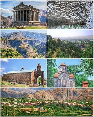
Garni, is a major village in the Kotayk Province of Armenia. It is known for the nearby classical temple. As of the 2011 census, the population of the village is 6,910.
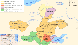
Mamikonian, or Mamikonean, was an aristocratic dynasty which dominated Armenian politics between the 4th and 8th centuries. They were the most notable noble house in Early Christian Armenia after the ruling Arsacid dynasty and held the hereditary positions of sparapet and dayeak, allowing them to play the role of kingmaker for the later Armenian kings. They ruled over extensive territories, including the Armenian regions of Tayk, Taron, Sasun, and Bagrevand, among others. The Mamikonians had a reputation as supporters of the Roman Empire in Armenia against Sasanian Iran, although they also served as viceroys under Persian rule. Their influence over Armenian affairs began to decline at the end of the 6th century and suffered a final, decisive blow after a failed rebellion against Arab rule over Armenia in 774/75.
Taron was a canton of the Turuberan province of Greater Armenia, roughly corresponding to the Muş Province of modern Turkey.

Noravank is a 13th-century Armenian monastery, located 122 km from Yerevan in a narrow gorge made by the Amaghu River, near the town of Yeghegnadzor in Armenia. The gorge is known for its tall, sheer, brick-red cliffs, directly across from the monastery. The monastery is best known for its two-storey Surb Astvatsatsin Church, which grants access to the second floor by way of a narrow stone-made staircase jutting out from the face of building.
Zenob Glak was an Armenian historian who became the first abbot of the Glak monastery in the Taron region of Greater Armenia. He began the chronology that would become the History of Taron of John Mamikonean. .

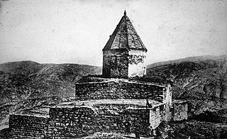
Surb Karapet Monastery of Mush was an Armenian Apostolic monastery in the historic province of Taron, about 30 km (19 mi) northwest of Mush (Muş), in present-day eastern Turkey.

Tsaghats Kar Monastery is a monastic complex located along the mountain foothills overlooking the Yeghegis River, between the villages of Yeghegis and Horbategh in the Vayots Dzor Province of Armenia. The monastery is located within walking distance of the fortress of Smbataberd.
Yeghrdut monastery was an Armenian monastery in the western part of Muş province of modern Turkey, approximately 22 km northwest of Muş city.
Saint Hakob of Akori Monastery, was an Armenian monastery located in the southeastern part of the historic region of Surmali. The monastery was located 4.7 kilometers southwest of Akori, a village at the northeastern slope of Mount Ararat. Destroyed by an earthquake and avalanche in 1840, Akori was later rebuilt. It is known today as Yenidoğan and remains a small Kurdish village.

Arakelots Monastery was an Armenian monastery in the historic province of Taron, 11 km south-east of Mush (Muş), in present-day eastern Turkey. According to tradition, Gregory the Illuminator founded the monastery to house relics of several apostles. The monastery was, however, most likely built in the 11th century. During the 12th-13th centuries it was a major center of learning. In the following centuries it was expanded, destroyed and renovated. It remained one of the prominent monasteries of Turkish (Western) Armenia until the Armenian genocide of 1915, when it was attacked and subsequently abandoned. It remained standing until the 1960s when it was reportedly blown up. Today, ruins of the monastery are still visible.
Aparank Monastery or Aparanq, or Holy Cross Aparank, is an Armenian monastery located in modern-day Turkey, Van province near the city of Bahçesaray. It was found within the borders of the historical Armenian province of Mokk.
The 461 Apahunik' earthquake affected the province of Apahunik', located to the north of Lake Van, in Anatolia.
The 139 Mcurn earthquake is listed in bibliographical records of seismology as having affected the city of Mcurn.

The 632 Armenia earthquake reportedly affected the region of Armenia. The primary source for this earthquake is the chronicle of Michael the Syrian, which only offers a brief narrative on the subject. According to it, a "tremor" (earthquake) destroyed many places in Armenia. It does not specifically name these places. Michael the Syrian dates this earthquake to 632, but the exact date is unknown. The chronology of Michael's narrative is considered unreliable, and it is possible that he misdated this earthquake.
The 743 Caspian Gates earthquake reportedly took place in the year 743 or 744 in the Caspian Gates. The location is identified with either Derbent, Russia or Talis, Iran.
The 840 Erzurum earthquake reportedly took place in the city of Qaliqala.
The 863 Dvin earthquake reportedly took place in the city of Dvin on 13 February, 863.
The 906 K'argop' earthquake took place in the monastery K'argop', Armenia, c. 906. The monastery was also known as Xotakerk', the monastery of the Vegetarians. The earthquake occurred approximately 150 years following the 735 Vayots Dzor Province earthquake, and affected the same region.
Üçdere is a village in Muş District, Muş Province, eastern Turkey. Its population is 799 (2021). It is located 6 kilometers from the center of Muṣ.