Related Research Articles
Year 139 (CXXXIX) was a common year starting on Wednesday of the Julian calendar. At the time, in Western civilization, it was known as the Year of the Consulship of Hadrianus and Praesens. The denomination 139 for this year has been used since the early medieval period, when the Anno Domini calendar era became the prevalent method in Europe for naming years.
Year 863 (DCCCLXIII) was a common year starting on Friday of the Julian calendar.

Year 735 (DCCXXXV) was a common year starting on Saturday of the Julian calendar. The denomination 735 for this year has been used since the early medieval period, when the Anno Domini calendar era became the prevalent method in Europe for naming years.

Smbat I, sometimes Smbat A Martyr was the second king of the medieval Kingdom of Armenia of the Bagratuni dynasty, and son of Ashot I. He is the father of Ashot II and Abas I.
Ashot I was a king of Armenia who oversaw the beginning of Armenia's second golden age. He was the son of Smbat VIII the Confessor and was a member of the Bagratuni dynasty.
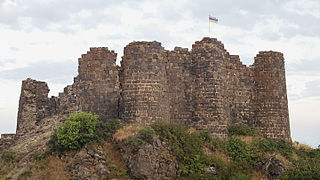
Amberd is a 10th-century fortress located 2,300 meters (7,500 ft) above sea level, on the slopes of Mount Aragats at the confluence of the Arkashen and Amberd rivers in the province of Aragatsotn, Armenia. The name translates to "fortress in the clouds" in Armenian. It is also the name incorrectly attributed to Vahramashen Church, the 11th-century Armenian church near the castle. The village of Byurakan is 6.4 kilometres (4.0 mi) from the site of Amberd.
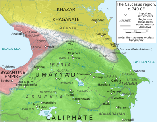
Arminiya, also known as the Ostikanate of Arminiya or the Emirate of Armenia, was a political and geographic designation given by the Muslim Arabs to the lands of Greater Armenia, Caucasian Iberia, and Caucasian Albania, following their conquest of these regions in the 7th century. Though the caliphs initially permitted an Armenian prince to represent the province of Arminiya in exchange for tribute and the Armenians' loyalty during times of war, Caliph Abd al-Malik ibn Marwan introduced direct Arab rule of the region, headed by an ostikan with his capital in Dvin. According to the historian Stephen H. Rapp in the third edition of the Encyclopaedia of Islam:
Early Arabs followed Sāsānian, Parthian Arsacid, and ultimately Achaemenid practice by organising most of southern Caucasia into a large regional zone called Armīniya.
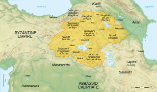
Bagratid Armenia was an independent Armenian state established by Ashot I of the Bagratuni dynasty in the early 880s following nearly two centuries of foreign domination of Greater Armenia under Arab Umayyad and Abbasid rule. With each of the two contemporary powers in the region—the Abbasids and Byzantines—too preoccupied to concentrate their forces on subjugating the region, and with the dissipation of several of the Armenian nakharar noble families, Ashot succeeded in asserting himself as the leading figure of a movement to dislodge the Arabs from Armenia.

A devastating earthquake known in scientific literature as the Earthquake of 749 struck on January 18, 749, in areas of the Umayyad Caliphate, with the epicenter in Galilee. The most severely affected areas were west and east of the Jordan River. The cities of Tiberias, Beit She'an, Pella, Gadara, and Hippos were largely destroyed, while many other cities across the Levant were heavily damaged. The casualties numbered in the tens of thousands.
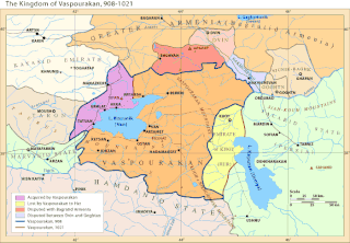
The Kingdom of Vaspurakan was a medieval Armenian kingdom centered on Lake Van, located in what is now eastern Turkey and northwestern Iran. It was named after Vaspurakan, a province of historic Greater Armenia. Ruled by the Artsruni dynasty, it competed and cooperated with the Bagratuni-ruled Kingdom of Armenia for a little over a century until its last king ceded the kingdom to the Byzantine Empire in 1021.

The Bagratuni or Bagratid dynasty was an Armenian royal dynasty which ruled the medieval Kingdom of Armenia from c. 885 until 1045. Originating as vassals of the Kingdom of Armenia of antiquity, they rose to become the most prominent Armenian noble family during the period of Arab rule in Armenia, eventually establishing their own independent kingdom. Their domain included regions of Armenia such as Shirak, Bagrevand, Kogovit, Syunik, Lori, Vaspurakan, Vanand and Taron. Many historians, such as Cyril Toumanoff, Nicholas Adontz and Ronald Suny, consider them to be the progenitors of the Georgian royal Bagrationi dynasty.
The 499 Nicopolis earthquake took place in September 499. It affected the cities of Nicopolis, Neocaesarea, Arsamosata, and Abarne.
The 461 Apahunik' earthquake affected the province of Apahunik', located to the north of Lake Van, in Anatolia.
The 363 Arsakawan earthquake took place c. 363. It affected the cities of Arsakawan and Salat.
The 602 Surb Karapet Monastery earthquake took place in 602 and affected the Surb Karapet Monastery, located in the district of Taron.
The 632 Armenia earthquake reportedly affected the region of Armenia. The primary source for this earthquake is the chronicle of Michael the Syrian, which only offers a brief narrative on the subject. According to it, a "tremor" (earthquake) destroyed many places in Armenia. It does not specifically name these places. Michael the Syrian dates this earthquake to 632, but the exact date is unknown. The chronology of Michael's narrative is considered unreliable, and it is possible that he misdated this earthquake.
The 743 Caspian Gates earthquake reportedly took place in the year 743 or 744 in the Caspian Gates. The location is identified with either Derbent, Russia or Tālesh, Iran.
The 840 Erzurum earthquake reportedly took place in the city of Qaliqala.
The 906 K'argop' earthquake took place in the monastery K'argop', Armenia, c. 906. The monastery was also known as Xotakerk', the monastery of the Vegetarians. The earthquake occurred approximately 150 years following the 735 Vayots Dzor Province earthquake, and affected the same region.
The 995 Balu earthquake took place in 995 or 996. It reportedly affected the Armenian areas of Balu, Cop'k, Palnatun, and the districts of Hasteank and Xorjean.