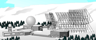
9th Space Warning Squadron

Last updated
9th Space Warning Squadron

9th Space Warning Squadron.PNG

9th Space Warning Squadron emblem
Active 1986-1995
Country United States
Branch United States Air Force
Type Space Operations
Role Missile Warning
Part of 14 AF/21 SW
Garrison/HQ Robins AFB, Georgia

The United States Air Force's 9th Space Warning Squadron (9 SWS) was a United States Air Force missile warning unit located at Robins AFB, Georgia.

United States Air Force Air and space warfare branch of the United States Armed Forces

The United States Air Force (USAF) is the aerial and space warfare service branch of the United States Armed Forces. It is one of the five branches of the United States Armed Forces, and one of the seven American uniformed services. Initially formed as a part of the United States Army on 1 August 1907, the USAF was established as a separate branch of the U.S. Armed Forces on 18 September 1947 with the passing of the National Security Act of 1947. It is the youngest branch of the U.S. Armed Forces, and the fourth in order of precedence. The USAF is the largest and most technologically advanced air force in the world. The Air Force articulates its core missions as air and space superiority, global integrated intelligence, surveillance, and reconnaissance, rapid global mobility, global strike, and command and control.

Missile self-propelled guided weapon system

In modern language, a missile, also known as a guided missile, is a guided self-propelled system, as opposed to an unguided self-propelled munition, referred to as a rocket. Missiles have four system components: targeting or missile guidance, flight system, engine, and warhead. Missiles come in types adapted for different purposes: surface-to-surface and air-to-surface missiles, surface-to-air missiles, air-to-air missiles, and anti-satellite weapons. All known existing missiles are designed to be propelled during powered flight by chemical reactions inside a rocket engine, jet engine, or other type of engine. Non-self-propelled airborne explosive devices are generally referred to as shells and usually have a shorter range than missiles.

Georgia (U.S. state) State of the United States of America

Georgia is a state in the Southeastern United States. It began as a British colony in 1733, the last and southernmost of the original Thirteen Colonies to be established. Named after King George II of Great Britain, the Province of Georgia covered the area from South Carolina south to Spanish Florida and west to French Louisiana at the Mississippi River. Georgia was the fourth state to ratify the United States Constitution, on January 2, 1788. In 1802–1804, western Georgia was split to the Mississippi Territory, which later split to form Alabama with part of former West Florida in 1819. Georgia declared its secession from the Union on January 19, 1861, and was one of the original seven Confederate states. It was the last state to be restored to the Union, on July 15, 1870. Georgia is the 24th largest and the 8th most populous of the 50 United States. From 2007 to 2008, 14 of Georgia's counties ranked among the nation's 100 fastest-growing, second only to Texas. Georgia is known as the Peach State and the Empire State of the South. Atlanta, the state's capital and most populous city, has been named a global city. Atlanta's metropolitan area contains about 55% of the population of the entire state.

Contents

History

The 9th Space Warning Squadron was originally constituted as the 9th Missile Warning Squadron (9 MWS) on 4 January 1985, and activated at Robins AFB on 1 July 1985. The 9 MWS controlled the Southeast facing AN/FPS-123 PAVE PAWS radar site, [1] providing warning to detect sea-launched and intercontinental ballistic missiles. The site went mission operational on 10 November 1986. Later use of the radar included support for the USAF space surveillance network by providing satellite vehicle surveillance, tracking, and radar space object identification. With these added mission areas, the unit was redesignated 9th Space Warning Squadron (9 SWS). [2]

PAVE PAWS

PAVE PAWS is an elaborate Cold War early warning radar and computer system developed in 1980 to "detect and characterize a sea-launched ballistic missile attack against the United States". With the first solid-state phased array deployed, the system at the perimeter of the contiguous United States used a pair of Raytheon AN/FPS-115 radar sets at each site as part of the United States Space Surveillance Network.

The United States Space Surveillance Network detects, tracks, catalogs and identifies artificial objects orbiting Earth, e.g. active/inactive satellites, spent rocket bodies, or fragmentation debris. The system is the responsibility of the Joint Functional Component Command for Space, part of the United States Strategic Command (USSTRATCOM).

As the likelihood of sea-based missile attacks from the Gulf of Mexico decreased, and the low probability of missile attacks from the South, the United States Air Force decided to close southern-facing PAVE PAWS sites at Robins AFB and Eldorado AS, Texas. Two radar faces, one each from Robins AFB and Eldorado AS, were moved to Clear AFS, Alaska as part of the BMEWS upgrade in 1998. [3]

Gulf of Mexico An Atlantic Ocean basin extending into southern North America

The Gulf of Mexico is an ocean basin and a marginal sea of the Atlantic Ocean, largely surrounded by the North American continent. It is bounded on the northeast, north and northwest by the Gulf Coast of the United States, on the southwest and south by Mexico, and on the southeast by Cuba. The U.S. states of Texas, Louisiana, Mississippi, Alabama, and Florida border the Gulf on the north, which are often referred to as the "Third Coast", in comparison with the U.S. Atlantic and Pacific coasts.

Texas State of the United States of America

Texas is the second largest state in the United States by both area and population. Geographically located in the South Central region of the country, Texas shares borders with the U.S. states of Louisiana to the east, Arkansas to the northeast, Oklahoma to the north, New Mexico to the west, and the Mexican states of Chihuahua, Coahuila, Nuevo León, and Tamaulipas to the southwest, while the Gulf of Mexico is to the southeast.

Alaska State of the United States of America

Alaska is a U.S. state in the northwest extremity of North America, just across the Bering Strait from Asia. The Canadian province of British Columbia and territory of Yukon border the state to the east, its most extreme western part is Attu Island, and it has a maritime border with Russia to the west across the Bering Strait. To the north are the Chukchi and Beaufort seas—southern parts of the Arctic Ocean. The Pacific Ocean lies to the south and southwest. It is the largest state in the United States by area and the seventh largest subnational division in the world. In addition, it is the 3rd least populous and the most sparsely populated of the 50 United States; nevertheless, it is by far the most populous territory located mostly north of the 60th parallel in North America: its population—estimated at 738,432 by the United States Census Bureau in 2015— is more than quadruple the combined populations of Northern Canada and Greenland. Approximately half of Alaska's residents live within the Anchorage metropolitan area. Alaska's economy is dominated by the fishing, natural gas, and oil industries, resources which it has in abundance. Military bases and tourism are also a significant part of the economy.

Assignments

Major Command

Wings/Groups

21st Space Wing

The 21st Space Wing is a unit of the Air Force Space Command based at Peterson Air Force Base, Colorado. The unit is tasked with the operation of early missile warning and space object detection equipment around the world in support of NORAD and USSTRATCOM through a network of command and control units and ground-based sensors operated by geographically separated units around the world.

1st Space Wing

The 1st Space Wing was a wing of the United States Air Force active from 1983 to 1992 at Peterson Air Force Base, Colorado as part of Air Force Space Command.

Previous designations

Equipment Operated

See also

Ballistic Missile Early Warning System

The RCA 474L Ballistic Missile Early Warning System was a United States Air Force Cold War early warning radar, computer, and communications system, for ballistic missile detection. The network of 12 radars, which was constructed beginning in 1958 and became operational in 1961, was for detecting "a mass ballistic missile attack launched on northern approaches [for] 15 to 25 minutes' warning time" also provided Project Space Track satellite data.
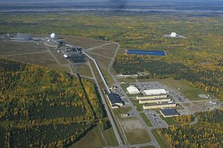
Related Research Articles

Air Force Space Command Major command of the United States Air Force responsible for space forces

Air Force Space Command (AFSPC) is a major command of the United States Air Force, with its headquarters at Peterson Air Force Base, Colorado. AFSPC supports U.S. military operations worldwide through the use of many different types of space operations. Operationally, AFSPC is an Air Force major command subordinate to U.S. Strategic Command (USSTRATCOM), a unified combatant command. As of 2019 it is the primary space force for the U.S. Armed Forces.

Clear Air Force Station

Clear Air Force Station is a United States Air Force Station radar station for detecting incoming ICBMs and submarine-launched ballistic missiles to NORAD's command center and to provide Space Surveillance data to Air Force Space Command's Space Control Center (SCC). Clear's AN/FPS-123 Upgraded Early Warning Radar is part of the Solid State Phased Array Radar System (SSPARS) which also includes those at Beale AFB, Cape Cod AFS, RAF Fylingdales and Thule Site J. The "historic property" was one of the Alaska World War II Army Airfields and later a Cold War BMEWS site providing NORAD data to Colorado's BMEWS Central Computer and Display Facility (CC&DF).

10th Space Warning Squadron

The United States Air Force's 10th Space Warning Squadron, is a missile warning unit located at Cavalier AFS, North Dakota.

9th Space Division

The 9th Space Division is an inactive United States Air Force organization. Its last assignment was with Air Force Space Command, being stationed at Patrick Air Force Base, Florida. It was inactivated on 1 October 1991.

Eldorado Air Force Station

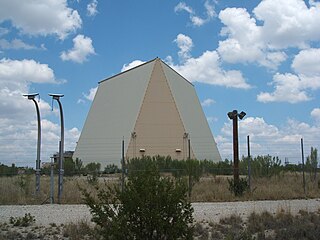
Eldorado Air Force Station located 35 miles south of San Angelo, Texas was one of the four unique AN/FPS-115 PAVE PAWS, early-warning phased-array radar systems. The 8th Space Warning Squadron, 21st Space Wing, Air Force Space Command operated at Eldorado Air Force Station.

Cape Cod Air Force Station

Cape Cod Air Force Station is a U.S. Air Force station located in the northwest corner of Joint Base Cape Cod, United States, on Flatrock Hill in Massachusetts. It consists of one PAVE PAWS radar station and is in continuous operation.

6th Space Warning Squadron

The 6th Space Warning Squadron is located at Cape Cod Air Force Station, in Sandwich, Massachusetts. It operates the PAVE PAWS radar to watch for submarine launched and intercontinental ballistic missiles launched toward North America. The squadron is assigned to the 21st Space Wing, Peterson Air Force Base, Colorado. The squadron was first organized in October 1979 as the 6th Missile Warning Squadron

7th Space Warning Squadron

The 7th Space Warning Squadron guards the U.S. West Coast against sea-launched ballistic missiles from the eastern outskirts of Beale Air Force Base approximately 8 miles (13 km) east of Marysville, California. The 7th SWS is a geographically separated unit of the 21st Space Wing, Peterson Air Force Base, Colorado Springs, Colorado.

12th Space Warning Squadron

The 12th Space Warning Squadron is a United States Air Force ground-based radar used for missile warning, missile defense and space situation awareness, stationed at Thule Air Base, Greenland.

8th Space Warning Squadron

The United States Air Force's 8th Space Warning Squadron is an Air Force Reserve missile warning unit located at Buckley Air Force Base, Colorado. The 8th works alongside its active duty counterpart, the 2d Space Warning Squadron, on the Defense Support Program and Space-Based Infrared System programs.

Charleston Air Force Station

Charleston Air Force Station is a defunct Air Force Station that opened in 1952 and closed in 1980. It was located in Charleston, Maine and is the site of a radar station and other buildings. After closure, it was redeveloped into a juvenile jail for the state of Maine.

Calumet Air Force Station

Calumet Air Force Station is a closed United States Air Force General Surveillance Radar station. It is located 5.2 miles (8.4 km) east-southeast of Phoenix, Michigan. It was closed in 1988 by the Air Force, and turned over to the Federal Aviation Administration (FAA).

Port Austin Air Force Station

Port Austin Air Force Station is a closed United States Air Force General Surveillance Radar station. It is located 1.2 miles (1.9 km) south-southwest Port Austin, Michigan. It was closed in 1988 by the Air Force.

14th Test Squadron

The 14th Test Squadron is a United States Air Force unit located at Schriever Air Force Base, Colorado. It is an Air Force Reserve unit that augments the 17th Test Squadron. The squadron is responsible for testing and evaluating space systems and associated support equipment. The unit was originally established in 1972 as the 14th Missile Warning Squadron. The missile warning squadron was an active duty unit that operated early warning radars at eight locations around the United States until it was inactivated in 1980. The squadron was reactivated and given its current space test mission in 2000.

213th Space Warning Squadron

The 213th Space Warning Squadron of the Alaska Air National Guard provides early warning of Intercontinental ballistic missiles and Submarine-launched ballistic missiles to the Missile Correlation Center of North American Aerospace Defense Command. The squadron is a geographically separated unit assigned to the 168th Wing at Eielson Air Force Base.

Solid State Phased Array Radar System

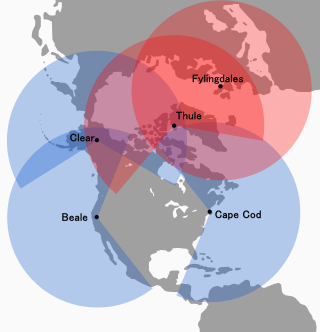
The Solid State Phased Array Radar System is a USAF radar, computer, and communications system for missile warning and space surveillance "at five (5) geographically separated units worldwide including Beale AFB, CA, Cape Cod, AFS, MA, Clear AFS, AK, RAF Fylingdales, UK, and Thule AB, Greenland." SSPARS completed replacement of the RCA 474L Ballistic Missile Early Warning System when the last SSPAR was operational at Clear in 2001, the year SSPARS equipment included:

AN/FPQ-16 PARCS

The AN/FPQ-16 Perimeter Acquisition Radar Attack Characterization System is a powerful phased-array radar system located in North Dakota. It is the second most powerful phased array radar system in the US Air Force's fleet of missile warning and space surveillance systems.

Eglin AFB Site C-6

Eglin AFB Site C-6 is an Air Force Space Command radar station which houses the AN/FPS-85 phased array radar, associated computer processing system(s), and radar control equipment. Commencing operations in 1969, the AN/FPS-85 was the first large phased array radar. The entire radar/computer system is located at a receiver/transmitter building and is supported by the site's power plant, fire station, 2 water wells, and other infrastructure for the system. As part of the US Air Force's Space Surveillance Network its mission is to detect and track spacecraft and other manmade objects in Earth orbit for "the Joint Space Operations Center satellite catalogue". With a peak radiated power of 32 megawatts the Air Force claims it is the most powerful radar in the world, and can track a basketball-sized object up to 22,000 nautical miles from Earth.

References

  1. "AN/FPS-123 PAVE PAWS"
  2. Lineage and Honors from Air Force Historical Research Agency
  3. Globalsecurity.org: "AN/FPS-115 PAVE PAWS"