A. R. Bowman Memorial Museum

Last updated
A. R. Bowman Memorial Museum
Crook County Bank - Prineville Oregon.jpg
Old Crook County Bank building
A. R. Bowman Memorial Museum
Established1971
Location Prineville, Oregon, U.S.A.
Type Oregon history
DirectorSandy Cohen
CuratorCrook County Historical Society
Website www.bowmanmuseum.org

The A. R. Bowman Memorial Museum is a local history museum in Prineville, Oregon, United States. Opened in 1971, the museum is housed in the old Crook County Bank Building which is listed on the National Register of Historic Places. The museum is run by the Crook County Historical Society and highlights the history of Crook County and central Oregon. Its collection includes many original pioneer artifacts, a large railroad exhibit, ranching and timber industry displays, furniture, garments, and historic photographs. The museum also has a research library.

Contents

Arthur Bowman

The museum is named after Arthur Ray Bowman, a Prineville businessman and civic leader. Bowman was born in Kansas and came to Prineville in 1910 after receiving a law degree from the University of Washington. He established a successful title and insurance company in Prineville the county seat of Crook County. Bowman was active in civic affairs throughout his life. He served as the County Judge for Crook County from 1936 to 1942. He also helped establish the Ochoco Irrigation District and the Prineville Airport. Bowman helped bring U.S. Highway 26 through Crook County. He was particularly interested in the construction of the Prineville Dam on the Crooked River. Because of his dedication to the project, the dam was renamed the Arthur R. Bowman Dam in his honor. He died in 1970, leaving a legacy of business success and civic responsibility. [1]

In 1971, Bowman's wife and two daughters donated the Crook County Bank building to Crook County for use as a museum. At that time, the Crook County Historical Society assumed the responsibility of operating the A. R. Bowman Memorial Museum through a contractual agreement with Crook County. [1] [2]

Historic building

The museum is housed in the historic Crook County Bank building. The building was constructed in 1910. It is a two-story Romanesque style building constructed using stone blocks from a local quarry located west of the Ochoco Viewpoint. This is the same quarry that provided the stone used to build the Crook County Courthouse in 1909. [3] [4]

The building's interior has not significantly changed since it was a community bank. The first floor still has the bank's original bronze teller cages, marble counter tops, etched art-glass, gilt and alabaster chandeliers, and the mahogany paneling that were the trappings of a prestigious banking institution in the first half of the 20th century. [3]

The building was first occupied by the Crook County Bank. When the Crook County Bank left in 1923, it was replaced by the Bank of Prineville and later the Prineville National Bank. When that bank became insolvent during the Great Depression, the building was purchased by A. R. Bowman for his title and insurance business. Bowman used the building for his various businesses from 1935 until his death in 1970. [3] [5]

The bank is an excellent example of Prineville's early 20th century development. Because of its unique architecture and its importance to the history of Prineville, the Crook County Bank Building was listed on the National Register of Historic Places on 19 June 1991. [3] [6]

Museum exhibits

The museum is run by the Crook County Historical Society and highlights the history of Crook County and central Oregon. The building's original bank interior has been maintained and is utilized in the museum's floor plan. There are major sections on local industry, transportation, and military history. [2] [4]

On the first floor is the Hall of History, which highlights Crook County's past. This includes exhibits on the City of Prineville Railroad, the local timber industry and United States Forest Service as well as pioneer furniture, garments, tools, and other artifacts. There are also many photographs of Crook County people, local landmarks, and historic event. The museum's displays include the bank's original teller cages with their marble counters and elegant woodwork. Museum visitors can look inside bank's safe and see old ledgers and other documents on display. [7]

The second floor rooms include a ranch tack room, an old-time bedroom, a dining room, a re-creation of the old Paulina store and post office, and exhibits of early medical and dental equipment. The museum's research library is also located on the second floor. The museum's research room contains approximately 700 reference books on Oregon history. Researchers can investigate the local timber industry, the Crook County range war between cattlemen and sheepherders, the Lost Meek Wagon Train, and many other subjects. The museum's gift shop has books on local history as well as souvenirs. [4] [5] [7]

In 1980, the Crook County Historical Society was offered a 1907 Studebaker Phaeton along with some old farm equipment. However, there was no place in the museum to house the vehicle and the large artifacts. As a result, the Society established a building fund to raise money for another building. In 1987, a museum annex was constructed at the Crook County fairgrounds. The building is owned by Crook County, but is operated by the Crook County Historical Society in the same manner as the main Bowman Museum. [2]

In 1996, the Bowman Museum hosted a Smithsonian traveling exhibit called Barn Again. That was the first time a traveling Smithsonian exhibit was shown in central Oregon. In 1997, the museum was awarded a general operating support grant from the Institute of Museum and Library Services, an independent agency of the United States Federal Government. That was a significant achievement since less than 20 percent of more than 1,000 institutional applicants received one of the Institute's competitive national grants. [2]

Visiting

The A.R. Bowman Memorial Museum is located on the southeast corner of Third and Main Street in Prineville. [8] The museum is open year around. From Memorial Day through Labor Day, the museum is open every day. The rest of the year, the museum is open five days a week, Tuesday through Saturday, The operating hour are normally from mid-morning until late afternoon. [4] [5]

Related Research Articles

<span class="mw-page-title-main">Crook County, Oregon</span> County in Oregon, United States

Crook County is one of the 36 counties in the U.S. state of Oregon. As of the 2020 census, the population was 24,738. The county seat is Prineville. The county is named after George Crook, a U.S. Army officer who served in the American Civil War and various Indian Wars.

<span class="mw-page-title-main">Prineville, Oregon</span> City in Oregon, United States

Prineville is a city in and the seat of Crook County, Oregon, United States. It was named for the first merchant located in the present location, Barney Prine. The population was 9,253 at the 2010 census.

<span class="mw-page-title-main">Ochoco National Forest</span> National Forest in Oregon

The Ochoco National Forest is located in the Ochoco Mountains in Central Oregon in the United States, north and east of the city of Prineville, location of the national forest headquarters. It encompasses 850,000 acres (3,440 km2) of rimrock, canyons, geologic oddities, dense pine forests, and high desert terrain, as well as the headwaters of the North Fork Crooked River. A 1993 Forest Service study estimated that the extent of old growth in the forest was 95,000 acres (38,000 ha).

<span class="mw-page-title-main">Keweenaw National Historical Park</span> U.S. national historical park in Michigan

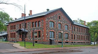
Keweenaw National Historical Park is a unit of the U.S. National Park Service. Established in 1992, the park celebrates the life and history of the Keweenaw Peninsula in the Upper Peninsula of the U.S. state of Michigan. As of 2009, it is a partly privatized park made up of two primary units, the Calumet Unit and the Quincy Unit, and 21 cooperating "Heritage Sites" located on federal, state, and privately owned land in and around the Keweenaw Peninsula. The National Park Service owns approximately 1,700 acres (690 ha) in the Calumet and Quincy Units. Units are located in Baraga, Houghton, Keweenaw, and Ontonagon counties.

<span class="mw-page-title-main">Central Oregon</span> Region in Oregon, United States

Central Oregon is a geographic region in the U.S. state of Oregon and is traditionally considered to be made up of Deschutes, Jefferson, and Crook counties. Other definitions include larger areas, often encompassing areas to the north towards the Columbia River, eastward towards Burns, or south towards Klamath Falls. These three counties have a combined population of 200,431 as of the 2010 census, with Deschutes the largest of the three counties, having approximately four times the population of the other two counties combined. As of 2015, the most populous city in the region is Bend, with an estimated 87,014 residents. As defined by the three county definition, Central Oregon covers 7,833 square miles (20,290 km2) of land. Central Oregon has had 3 record tourism years beginning in 2012. Over 2.2 million people visited Central Oregon in 2012 and again in 2013.

<span class="mw-page-title-main">Paulina, Oregon</span> Unincorporated community in the state of Oregon, United States

Paulina is an unincorporated community in Crook County, Oregon, United States. It is about 55 miles (89 km) east of Prineville on Oregon Route 380. It was named after Paiute Chief Paulina. Paulina post office was established in 1882. Paulina has one K-8 grade school. The community is the home of the Paulina Rodeo, which was the subject of a Kim Stafford poem, and the Paulina Ranger District of the Ochoco National Forest.

<span class="mw-page-title-main">Five Oaks Museum</span> History museum in Washington County, Oregon, United States

Five Oaks Museum, formerly known as the Washington County Museum, is a history museum in Washington County, Oregon, United States. It is located at the Rock Creek campus of Portland Community College (PCC), north of Beaverton, Oregon. From 2012 to 2017, its public exhibit space was located in downtown Hillsboro, Oregon, before it was moved back to PCC, its pre-2012 location and where the museum's research facility had already been located.

<span class="mw-page-title-main">Oregon Historical Society Museum</span> History museum in Portland, Oregon

The Oregon Historical Society Museum is a history museum housed at the Oregon Historical Society in downtown Portland, Oregon, United States. The museum was created in 1898 and receives about 44,000 visitors annually.

<span class="mw-page-title-main">Crooked River (Oregon)</span> River in Oregon, United States

The Crooked River is a tributary, 125 miles (201 km) long, of the Deschutes River in the U.S. state of Oregon. The river begins at the confluence of the South Fork Crooked River and Beaver Creek. Of the two tributaries, the South Fork Crooked River is the larger and is sometimes considered part of the Crooked River proper. A variant name of the South Fork Crooked River is simply "Crooked River". The Deschutes River flows north into the Columbia River.

<span class="mw-page-title-main">Milwaukee County Historical Society</span> History Museum & Research Center in North Old World Third Street Milwaukee, WI

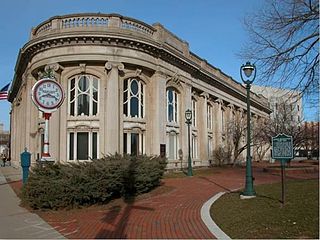
The Milwaukee County Historical Society, also known as MCHS, is a local historical society in Milwaukee County, Wisconsin. Founded in 1935, the organization was formed to preserve, collect, recognize, and make available materials related to Milwaukee County history. It is located in downtown Milwaukee in the former Second Ward Savings Bank building.

<span class="mw-page-title-main">Arthur R. Bowman Dam</span> Dam in Oregon, U.S.

Arthur R. Bowman Dam is an earth-type irrigation dam on the Crooked River in the U.S. state of Oregon. It is in Crook County. Its reservoir is called Prineville Reservoir.

<span class="mw-page-title-main">Crook County Bank Building</span> United States historic place

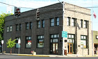
The Crook County Bank is a historic bank building in Prineville, Oregon, United States. It was built in 1910 using stone blocks from a local quarry. The building was first use as a bank and then occupied by title and insurance business until 1971, when ownership was transferred to Crook County for use as a local history museum. Today, the Crook County Bank building is the home of the A. R. Bowman Memorial Museum. Because of its importance to the history of Prineville, the Crook County Bank Building is listed on the National Register of Historic Places.

<span class="mw-page-title-main">Chemung County Historical Society</span>

The Chemung County Historical Society is headquartered in the historic Chemung Canal Bank Building in Elmira, New York. It is dedicated to the collection, preservation, and presentation of the history of the Chemung River Valley region. The society was founded in 1923 and first chartered by New York State in 1947. It is accredited by the American Alliance of Museums, and currently operates two cultural repositories, the Chemung Valley History Museum and the Booth Library, both as non-profit educational institutions.

<span class="mw-page-title-main">Lamonta Compound – Prineville Supervisor's Warehouse</span> United States historic place

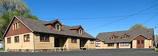
The Lamonta Compound – Prineville Supervisor's Warehouse is a complex of buildings and related infrastructure owned an operated by the Ochoco National Forest in Prineville, Oregon, United States. Built by the Civilian Conservation Corps in 1933–1934, it is the headquarters for field operations in the national forest and is typical of projects carried out by the CCC on behalf of the Forest Service. It represents that era's shift in the Forest Service's architectural vision toward comprehensive site planning, as well as its policy evolution from custodial superintendence of the national forests toward active natural resource management.

<span class="mw-page-title-main">Roba Ranch</span> United States historic place

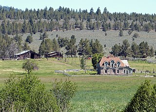
The Roba Ranch is a pioneer ranch located near the small unincorporated community of Paulina in Crook County, Oregon. The ranch is named for George and Mary Roba, sheep ranchers who acquired the property in 1892. Most of the important ranch buildings were constructed by the Roba family between about 1892 and 1910. Today, the ranch covers 1,480 acres (6.0 km2) and is privately owned. The ranch was listed on the National Register of Historic Places in 2007.

Lane County History Museum, located on the county fairgrounds in Lane County in Eugene, Oregon, United States, has ongoing exhibits on the Oregon Trail, the county courthouse, historic vehicles, selections of artifacts from across the county, and photographs. The museum also provides research materials by appointment in their closed stack library, school tours, a variety of public events, and runs an annual grant program for heritage outreach projects. The museum and the Lane County Clerk's Building near the museum entrance are both administered by the Lane County Historical Society.

<span class="mw-page-title-main">Horace P. Belknap</span> American politician

Horace Preston Belknap was an American pioneer doctor, businessman, and a state legislator from the state of Oregon. Belknap was one of the first physicians to establish a medical practice in Central Oregon. He also served three terms in the Oregon House of Representatives as a Republican legislator, representing a large and rural district in central and southern Oregon.

<span class="mw-page-title-main">Barney Prine</span>

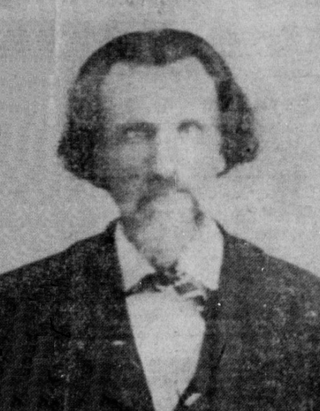
Francis Barnett Prine was an American pioneer who was one of the first settlers to homestead in the Ochoco country of central Oregon. When he was young, Prine traveled with his family from Missouri to Oregon's Willamette Valley over the Oregon Trail. He served in the 1st Oregon Volunteer Infantry Regiment during the American Civil War. Prine later moved to the Central Oregon, where he established several businesses in what became Prineville, Oregon, a town named in his honor.

<span class="mw-page-title-main">Cass A. Cline</span>

Cass Adelbert Cline was an American pioneer who was an early settler in central Oregon. Cline’s family moved to Oregon when he was a small child, settling west of the Cascade Mountains near Roseburg. As a young man, Cline moved to central Oregon and claimed homestead land along the Deschutes River. He later became a well-known dentist, property developer, and race horse breeder. Today, a waterfall on the Deschutes River, a nearby mountain group, and a state park bear his name.

<span class="mw-page-title-main">Crook County Courthouse</span> Courthouse in Prineville, Oregon, United States

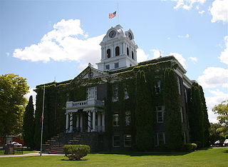
Crook County Courthouse is a courthouse located in Prineville, Oregon, United States. The present courthouse, built in 1909, replaced an earlier courthouse built in 1889. In November 2021, voters of Crook County, Oregon approved a bond measure to raise up to $35 million to build a new Justice Center on a different site.

References

  1. 1 2 "Arthur Ray Bowman" Archived 2009-01-30 at the Wayback Machine , A. R. Bowman Memorial Museum, Prineville Historical Society, Prineville, Oregon, 2008.
  2. 1 2 3 4 "Crook County Historical Society" Archived 2009-03-02 at the Wayback Machine , A. R. Bowman Memorial Museum, Prineville Historical Society, Prineville, Oregon, 2008.
  3. 1 2 3 4 "Bowman Museum" Archived 2009-01-30 at the Wayback Machine , A. R. Bowman Memorial Museum, Prineville Historical Society, Prineville, Oregon, 2008.
  4. 1 2 3 4 "Welcome to A.R. Bowman Memorial Bowman", A. R. Bowman Memorial Museum, Prineville Historical Society, Prineville, Oregon, 2008.
  5. 1 2 3 "Walking Tour" Archived 2011-05-14 at the Wayback Machine , Prineville Crook County Chamber of Commerce, www.visitprineville.com, Prineville, Oregon, 2008.
  6. "Crook County Bank Building", National Register of Historic Places, www.nationalregisterofhistoricalplaces.com, 18 February 2008.
  7. 1 2 "Welcome to Bowman Museum" Archived 2009-01-30 at the Wayback Machine , A.R. Bowman Memorial Museum, Prineville Historical Society, Prineville, Oregon, 2008.
  8. Images of America Prinville, Acadia Publishing, San Francisco, California, 2007, p. 42.

Coordinates: 44°18′10″N120°50′48″W / 44.3028°N 120.8468°W / 44.3028; -120.8468