The Reclamation Act of 1902 is a United States federal law that funded irrigation projects for the arid lands of 20 states in the American West.

The Deschutes River in central Oregon is a major tributary of the Columbia River. The river provides much of the drainage on the eastern side of the Cascade Range in Oregon, gathering many of the tributaries that descend from the drier, eastern flank of the mountains. The Deschutes provided an important route to and from the Columbia for Native Americans for thousands of years, and then in the 19th century for pioneers on the Oregon Trail. The river flows mostly through rugged and arid country, and its valley provides a cultural heart for central Oregon. Today the river supplies water for irrigation and is popular in the summer for whitewater rafting and fishing.

The Dolores River is a tributary of the Colorado River, approximately 241 miles (388 km) long, in the U.S. states of Colorado and Utah. The river drains a rugged and arid region of the Colorado Plateau west of the San Juan Mountains. Its name derives from the Spanish El Rio de Nuestra Señora de Dolores, River of Our Lady of Sorrows. The river was explored and possibly named by Juan Maria Antonio Rivera during a 1765 expedition from Santa Fe.

Lost River begins and ends in a closed basin in northern California and southern Oregon in the United States. The river, 60 miles (97 km) long, flows in an arc from Clear Lake Reservoir in Modoc County, California, through Klamath County, Oregon, to Tule Lake in Siskiyou County, California. About 46 mi (74 km) of Lost River are in Oregon, and 14 miles (23 km) are in California.

The Pick–Sloan Missouri Basin Program, formerly called the Missouri River Basin Project, was initially authorized by the Flood Control Act of 1944, which approved the plan for the conservation, control, and use of water resources in the Missouri River Basin.

Parker Dam is a concrete arch-gravity dam that crosses the Colorado River 155 miles (249 km) downstream of Hoover Dam. Built between 1934 and 1938 by the Bureau of Reclamation, it is 320 feet (98 m) high, 235 feet (72 m) of which are below the riverbed (the deep excavation was necessary in order to reach the bedrock on which the foundation of the dam was built), making it the deepest dam in the world. The portion of the dam above the foundation stands 85 feet (25.9 m) tall, making it the only dam in the world that stands more underground than above ground. The dam's primary functions are to create a reservoir, and to generate hydroelectric power. The reservoir behind the dam is called Lake Havasu and can store 647,000 acre⋅ft (798,000,000 m3; 2.11×10¹¹ US gal; 1.76×10¹¹ imp gal). The dam straddles the Arizona-California state border at the narrows the river passes through between the Whipple Mountains in San Bernardino County, California and the Buckskin Mountains in La Paz County, Arizona.

New Melones Dam is an earth and rock filled embankment dam on the Stanislaus River, about 5 miles (8.0 km) west of Jamestown, California, United States, on the border of Calaveras County and Tuolumne County. The water impounded by the 625-foot-tall (191 m) dam forms New Melones Lake, California's fourth-largest reservoir, in the foothills of the Sierra Nevada east of the San Joaquin Valley. The dam serves mainly for irrigation water supply, and also provides hydropower generation, flood control, and recreation benefits.

San Luis Dam is a major earth-filled dam in Merced County, California, which forms San Luis Reservoir, the largest off-stream reservoir in the United States. The dam and reservoir are located in the Diablo Range to the east of Pacheco Pass and about 10 miles (16 km) west of Los Banos. San Luis Dam, a jointly-owned state and federal facility, stores more than 2 million acre feet (2.5 km3) of water for the California State Water Project and the federal Central Valley Project. Although the dam is located in the valley of San Luis Creek, the majority of its water comes from man-made aqueducts which are supplied from other rivers in Northern California.

The Klamath Project is a water-management project developed by the United States Bureau of Reclamation to supply farmers with irrigation water and farmland in the Klamath Basin. The project also supplies water to the Tule Lake National Wildlife Refuge, and the Lower Klamath National Wildlife Refuge. The project was one of the first to be developed by the Reclamation Service, which later became the Bureau of Reclamation.

The Crooked River is a tributary, 125 miles (201 km) long, of the Deschutes River in the U.S. state of Oregon. The river begins at the confluence of the South Fork Crooked River and Beaver Creek. Of the two tributaries, the South Fork Crooked River is the larger and is sometimes considered part of the Crooked River proper. A variant name of the South Fork Crooked River is simply "Crooked River". The Deschutes River flows north into the Columbia River.

Owyhee Reservoir or Owyhee Lake is a reservoir on the Owyhee River in Malheur County, Oregon, United States. Located in far Eastern Oregon near the Idaho border, the reservoir is Oregon's longest at 52 miles (84 km). The 13,900-acre (56 km2) lake is home to several species of fish, including crappie, rainbow trout, largemouth bass, smallmouth bass, yellow perch, and brown bullhead. An artificial lake, it was created in 1932 with the completion of the Owyhee Dam. The lake supplies water for irrigation for 1,800 farms covering 118,000 acres of land in Eastern Oregon and Southwestern Idaho. Seasonal Lake Owyhee State Park is located on the northeast shore and includes a boat ramp.

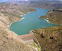
The Prineville Reservoir is in the high desert hills of Central Oregon, Oregon, United States. The reservoir is on the Crooked River 14 miles (22.5 km) southeast of Prineville, and 29 miles (46.7 km) east of Bend. This reservoir is a popular retreat for most of Central Oregon. It is near the geographic center of Oregon. Prineville Reservoir State Park is managed by the Oregon Parks and Recreation Department.

McKay Reservoir is a reservoir in Umatilla County of the U.S. state of Oregon. It is an impoundment of McKay Creek, a tributary of the Umatilla River. The reservoir is located 6 miles (9.7 km) south of Pendleton on U.S. Route 395. The reservoir has a capacity of 65,534 acre-feet (80,835,000 m3) of water. The reservoir and land that immediately surrounds it are designated as the McKay Creek National Wildlife Refuge. The reservoir and creek that it impounds are named for Dr. William C. McKay. McKay was an early settler in the Pendleton, Oregon area. He settled near the mouth of McKay Creek about 1851. The place was originally called Houtama. He died in Pendleton in 1893.
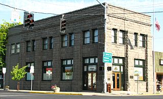
The A. R. Bowman Memorial Museum is a local history museum in Prineville, Oregon, United States. Opened in 1971, the museum is housed in the old Crook County Bank Building which is listed on the National Register of Historic Places. The museum is run by the Crook County Historical Society and highlights the history of Crook County and central Oregon. Its collection includes many original pioneer artifacts, a large railroad exhibit, ranching and timber industry displays, furniture, garments, and historic photographs. The museum also has a research library.
Savage Rapids Dam was an approximately 39-foot-high (12 m), 500-foot-long (150 m) irrigation diversion dam spanning the mainstem of the Rogue River in Josephine County, Oregon. The dam was demolished and removed in 2009. From 1921 until the spring of 2009, the Savage Rapids Dam almost entirely functioned for irrigation purposes, and it did not provide any flood control, hydro-electric power, inland waterway, or other significant beneficial uses. It only provided very minor recreational or wildlife benefits.

Cedar Bluff Reservoir is a reservoir in Trego County, Kansas, United States. Built and managed by the U.S. Bureau of Reclamation for irrigation and area water supply, it is also used for flood control and recreation. Cedar Bluff State Park is located on its shore.
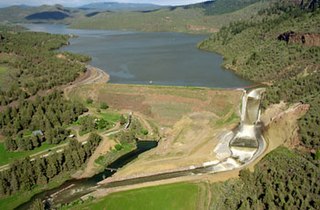
Ochoco Dam is a dam in Central Oregon, 6 miles (9.7 km) east of Prineville in Crook County, Oregon, in the United States.

Kirwin Reservoir is a reservoir in Phillips County, Kansas, United States. It is located next to the city of Kirwin in northern Kansas. The U.S. Bureau of Reclamation built it and continues to operate it for the purposes of flood control and area irrigation. The Kirwin National Wildlife Refuge lies on its shores.

Lake Tahoe Dam is a concrete gravity dam on the Truckee River, at the outlet of Lake Tahoe in Placer County, California.
The Central Oregon Jobs and Water Security Act is a land-use and water bill related to the Crooked River in Oregon and the Bowman Dam. H.R. 2640 would modify features of the Crooked River Project located in central Oregon, north of the city of Prineville, and prioritize how water from the project would be allocated for different uses. It was introduced into the United States House of Representatives during the 113th United States Congress.