
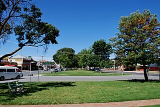
Stawell ( "stall"), is an Australian town in the Wimmera region of Victoria 237 kilometres (147 mi) west-north-west of the state capital, Melbourne. Located within the Shire of Northern Grampians local government area, it is a seat of local government for the shire and its main administrative centre. At the 2021 census, Stawell had a population of 6,220.
Yea is a town in Victoria, Australia 112 kilometres (70 mi) north-east of the state capital Melbourne at the junction of the Goulburn Valley Highway and the Melba Highway, in the Shire of Murrindindi local government area. In an area originally inhabited by the Taungurung people, it was first visited by Europeans of the Hume and Hovell expedition in 1824, and within 15 years most of the land in the area had been taken up by graziers. Surveyed in 1855, the township grew as a service centre for grazing, gold-mining and timber-getting in the area.
Kinglake is a town in Victoria, Australia, 56 km (35 mi) north-east of Melbourne's Central Business District, located within the Shires of Murrindindi and Nillumbik local government areas. Kinglake is on the traditional lands of the Taungurung and Wurundjeri peoples.

Alexandra is a town in north-east Victoria, Australia, 130 kilometres north-east of the State Capital, Melbourne. It is located at the junction of the Goulburn Valley Highway (B340) and Maroondah Highway (B360), in the Shire of Murrindindi local government area. At the 2021 census, the town had a population of 2,801 and the broader area a population of 6,828.

Maldon is a town in Victoria, Australia, in the Shire of Mount Alexander local government area. It has been designated "Australia's first notable town" and is notable for its 19th-century appearance, maintained since gold-rush days. At the 2016 census, Maldon had a population of 1,513.

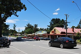
Walhalla is a town in Victoria, Australia, founded as a gold-mining community in late 1862, and at its peak, home to around 4,000 residents. As of 2023, the town has a population of 20 permanent residents, though it has a large proportion of houses owned as holiday properties. It attracts large numbers of tourists and is a major focus of the regional tourism industry. The town's name is taken from an early gold mine in the area, named for the German hall of fame, the Walhalla temple.

Woods Point is a town in east-central Victoria, Australia and is located on the banks of the Goulburn River. At the 2021 census, Woods Point and the surrounding area had a population of 33, down from 37 in 2016 census.

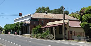
Kevington is a town in Victoria, Australia, located south of Jamieson on the Mansfield - Woods Point Road, in the Shire of Mansfield. The Goulburn River runs through Kevington.
Matlock is a locality in Victoria, Australia, located about 140 kilometres north-east of Melbourne, located within the Shires of Mansfield and Yarra Ranges local government areas. Matlock recorded a population of 7 at the 2021 census.

Omeo is a town in Victoria, Australia on the Great Alpine Road, east of Mount Hotham, in the Shire of East Gippsland. At the 2016 census, Omeo had a population of 406. The name is derived from an Aboriginal word for 'mountains' or 'hills'. Omeo is affectionately known as the City of the Alps with many historic buildings remaining in the town. The town is still the commercial hub for the Omeo Region and is a service centre for outlying communities such as Benambra, Cobungra, Cassilis, Swifts Creek, and Ensay.
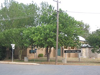
Mangoplah is a town approximately 36 kilometres (22 mi) south of Wagga Wagga in the Riverina region of New South Wales, Australia. At the 2016 census, Mangoplah had a population of 309. The name of the town is believed to mean "Kooris singing" in the Wiradjuri aboriginal language.

Cassilis is a ghost town in Gippsland, Victoria, Australia. It was named after a district and castle in Ayrshire, Scotland. In the late 19th century, at the peak of the gold boom, it was a thriving mining centre and home to more than 500 people.

Gaffneys Creek is a former mining settlement situated between Jamieson and Woods Point in Victoria, Australia. It is located at the junction of Gaffney and Raspberry Creeks in a steep valley in mountainous terrain. It is situated in the Shire of Mansfield on the unsealed Mansfield - Woods Point Rd.
Chewton is a town in central Victoria, Australia in the Shire of Mount Alexander local government area, 116 kilometres north west of the state capital, Melbourne. At the 2016 census, Chewton had a population of 1313.

Bethanga is a town in north-eastern Victoria, Australia in the Shire of Towong local government area, 390 kilometres (242 mi) from the state capital, Melbourne. At the 2016 census, Bethanga had a population of 471 and gives its name to the Bethanga Bridge.
Yalwal is the site of a former gold mining town of the same name situated 29 km (18 mi) west of Nowra at the confluence of the Danjera and Yarramunmun Creeks which then forms Yalwal Creek which flows into the Shoalhaven River in New South Wales, Australia.

Timor (/ˈtaɪˈmɔː/), is a locality in Central Goldfields Shire, Victoria, Australia. Timor is located 8 kilometres (5 mi) north of Maryborough, Victoria and 178 kilometres (111 mi) northwest of Melbourne, the state capital. At the 2021 census, Timor had a population of 68.

Colinton is a locality in the Snowy Monaro Region, New South Wales, Australia. At the 2021 census, it had a population of 115. There was once a village and railway station of the same name.
Coopers Creek is a locality and mine in the Gippsland region of Victoria, Australia. In the 1860s, Coopers Creek was settled during the Victorian gold rush and, throughout its history, gold, copper and lime have been mined there. Today, Coopers Creek is effectively limited to two camping sites, the first near the site of the mining town and the second to the east at Bruntons Bridge. Ruins from the locality's mining history, and the Copper Mine Hotel are all of the locality's history which survives. In August 2022, the 21 properties that comprise the town were listed for sale.
Clifton Creek is a locality in the Shire of East Gippsland, Victoria, Australia. In the 2016 census, Clifton Creek had a population of 237 people.


