A pelican crossing, or archaically pelicon crossing, is a type of pedestrian crossing with traffic signals for both pedestrians and vehicular traffic, activated by call buttons for pedestrians, with the walk signal being directly across the road from the pedestrian. The design is also found in the Isle of Man, the Channel Islands, the island of Ireland, Indonesia and Australia. The crossings began to be phased out in Great Britain in 2016, being replaced with puffin crossings which have pedestrian signals above the call button rather than across the road.

Tottenham Court Road is a London Underground and Elizabeth line station in St Giles in the West End of London. The station is served by the Central line, the Elizabeth line and the Charing Cross branch of the Northern line. The station is located at St Giles Circus, the junction of Tottenham Court Road, Oxford Street, New Oxford Street and Charing Cross Road and is in Travelcard Zone 1, with a second entrance at Dean Street.

A pedestrian is a person traveling on foot, whether walking or running. In modern times, the term usually refers to someone walking on a road or pavement, but this was not the case historically.

The M56 motorway, also known as the North Cheshire motorway, serves the Cheshire and Greater Manchester areas of England. It runs east to west from junction 4 of the M60 at Gatley, south of Manchester, to Dunkirk, approximately four miles north of Chester. With a length of 33.3 miles (53.6 km), it connects North Wales and the Wirral peninsula with much of the rest of North West England, serves business and commuter traffic heading towards Manchester, particularly that from the wider Cheshire area, and provides the main road access to Manchester Airport from the national motorway network.
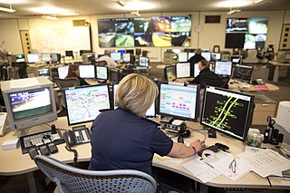
National Highways, formerly the Highways Agency and later Highways England, is a government-owned company charged with operating, maintaining and improving motorways and major A roads in England. It also sets highways standards used by all four UK administrations, through the Design Manual for Roads and Bridges. Within England, it operates information services through the provision of on-road signage and its Traffic England website, provides traffic officers to deal with incidents on its network, and manages the delivery of improvement schemes to the network.

The Chinese Pagoda is a landmark in Birmingham, England. It is a 40-foot granite carving of a Chinese pagoda, carved in Fujian, China and donated to the city by the Wing Yip brothers, founder of a local Chinese supermarket chain, in thanks to the city and its people for providing a home for them and their families and for the city's support over the years.
Annual average daily traffic, abbreviated AADT, is a measure used primarily in transportation planning, transportation engineering and retail location selection. Traditionally, it is the total volume of vehicle traffic of a highway or road for a year divided by 365 days. AADT is a simple, but useful, measurement of how busy the road is.
In traffic engineering, saturation describes the maximum traffic flow which can be handled by a junction. The saturation flow is the rate at which a continuous flow of vehicles can pass through a constant green signal, typically expressed in vehicles per hour or PCUs per hour.

The A1025 is a road in Harlow, England. It connects the A1169 with the M11 Junction 7A. The extension to the M11 opened to traffic on 10 June 2022. The road previously terminated on the A414, and before that it was allocated to a road in Norwich, which is now the A147 and A1242. In the road traffic statistics for 2020, the road sees 8400 vehicles per day between A1169 and A1019, but 28700 vehicles per day between the A1019 and A414.
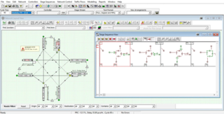
LinSig is software by JCT Consultancy which allows traffic engineers to model traffic signals and their effect on traffic capacities and queuing. As well as modelling the effects of traffic signals LinSig also optimises signal timings to reduce delay or increase capacity at a junction or group of interlinked junctions.
SignPlot is a software application for the design of UK traffic signs and their supports and foundations, developed and sold by Buchanan Computing.

Visa requirements for Indian citizens are administrative entry restrictions by the authorities of other states placed on citizens of India. As of 21 July 2022, Indian citizens had visa-free or visa on arrival or e-visa access to 60 countries and territories, ranking the Indian passport 87th out of 112, in terms of travel freedom according to the Henley Passport Index. With visa free entry to 22 countries and visa on arrival facility to 41 countries India shares 60th rank in Global Passport Power Rank.
Visa requirements for British citizens are administrative entry restrictions by the authorities of other states placed on citizens of the United Kingdom. As of 30 April 2022, British citizens had visa-free or visa on arrival access to 187 countries and territories, ranking their passport 5th in terms of travel freedom according to the Henley Passport Index. Additionally, the World Tourism Organisation also published a report on 15 January 2016 ranking the passport 1st in the world in terms of travel freedom, with the mobility index of 160.
Visa requirements for British Nationals (Overseas) are administrative entry restrictions by the authorities of other states and territories placed on British National (Overseas) passport holders. Several million people, the vast majority with a Hong Kong connection, hold this passport.
A smart motorway, also known in Scotland as an intelligent transport system, is a section of motorway in the United Kingdom that employs active traffic management (ATM) techniques to increase capacity through the use of MIDAS technology including variable speed limits and occasionally hard shoulder running and ramp metering at busy times. They were developed at the turn of the 21st century as a cost-effective alternative to traditional carriageway widening, with intended benefits ranging from more reliable journey times to lower vehicle emissions. However, despite the risk of a collision occurring between two moving vehicles being found to be decreased, there has been an acknowledged rise in the incidence of collisions involving vehicles where at least one was stationary in the first few years following the widespread removal of the hard shoulder on the country's busiest sections of motorway. Smart motorways garnered intense criticism from politicians, police representatives and motoring organisations, particularly from 2020 onwards, after a surge in near miss incidents and dozens of fatalities were revealed.

Cycling infrastructure is all infrastructure cyclists are allowed to use. Bikeways include bike paths, bike lanes, cycle tracks, rail trails and, where permitted, sidewalks. Roads used by motorists are also cycling infrastructure, except where cyclists are barred such as many freeways/motorways. It includes amenities such as bike racks for parking, shelters, service centers and specialized traffic signs and signals. The more cycling infrastructure, the more people get about by bicycle.

The Driver and Vehicle Standards Agency (DVSA) is an executive agency of the UK Department for Transport (DfT).

A shared-use path, mixed-use path or multi-use pathway is a path which is 'designed to accommodate the movement of pedestrians and cyclists'. Examples of shared-use paths include sidewalks designated as shared-use, bridleways and rail trails. A shared-use path typically has a surface that is asphalt, concrete or firmly packed crushed aggregate. Shared-use paths differ from cycle tracks and cycle paths in that shared-use paths are designed to include pedestrians even if the primary anticipated users are cyclists.
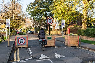
A Low Traffic Neighbourhood(LTN) is a scheme implemented to reduce through traffic in residential areas through the use of filtered permeability and traffic calming.
The Bus Open Data Service (BODS) is a government-funded service in England, established in 2020 as part of the Bus Services Act 2017. It was created in a partnership between ITO World, the Department for Transport and KPMG.