
The A41 is a trunk road between London and Birkenhead, England. Now in parts replaced by motorways, it passes through or near Watford, Kings Langley, Hemel Hempstead, Aylesbury, Bicester, Solihull, Birmingham, West Bromwich, Wolverhampton, Newport, Whitchurch, Chester and Ellesmere Port.

The A4 is a major road in England from Central London to Avonmouth via Heathrow Airport, Reading, Bath and Bristol. It is historically known as the Bath Road with newer sections including the Great West Road and Portway. The road was once the main route from London to Bath, Bristol and the west of England and formed, after the A40, the second main western artery from London.

The A6 is one of the main north–south roads in England. It runs from Luton in Bedfordshire to Carlisle in Cumbria, although it formerly started at a junction with the A1 at Barnet. It is the fourth longest numbered road in Britain; only the A1, A38 and A30 are longer.

The A44 is a major road in the United Kingdom that runs from Oxford in southern England to Aberystwyth in west Wales.

The A57 is a major road in England. It runs east from Liverpool to Lincoln via Warrington, Cadishead, Irlam, Patricroft, Eccles, Salford and Manchester, then through the Pennines over the Snake Pass (between the high moorlands of Bleaklow and Kinder Scout), around the Ladybower Reservoir, through Sheffield and past Worksop. Between Liverpool and Glossop, the road has largely been superseded by the M62, M602 and M67 motorways. Within Manchester a short stretch becomes the Mancunian Way, designated A57(M).

The A61 is a major trunk road in England connecting Derby and Thirsk in North Yorkshire by way of Alfreton, Clay Cross, Chesterfield, Sheffield, Barnsley, Wakefield, Leeds, Harrogate and Ripon. The road is closely paralleled by the M1 motorway between Derby and Leeds.

The A24 is a major road in England that runs for 53.2 miles (85.6 km) from Clapham in south-west London to Worthing on the English Channel in West Sussex via the suburbs of south-west London, as well as through the counties of Surrey and West Sussex.
The A19 is a major road in England running approximately parallel to and east of the A1 road. Although the two roads meet at the northern end of the A19, the two roads originally met at the southern end of the A19 in Doncaster, but the old route of the A1 was changed to the A638. From Sunderland northwards, the route was formerly the A108. In the past the route was known as the East of Snaith-York-Thirsk-Stockton-on-Tees-Sunderland Trunk Road. Most traffic joins the A19, heading for Teesside, from the A168 at Dishforth Interchange.

The A49 is an A road in western England, which traverses the Welsh Marches region. It runs north from Ross-on-Wye in Herefordshire via Hereford, Leominster, Ludlow, Shrewsbury and Whitchurch, then continues through central Cheshire to Warrington and Wigan before terminating at its junction with the A6 road just south of Bamber Bridge, near the junction of the M6, M65 and M61 motorways.
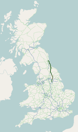
The A59 is a major road in England which is around 109 miles (175 km) long and runs from Wallasey, Merseyside to York, North Yorkshire. The alignment formed part of the Trunk Roads Act 1936, being then designated as the A59. It is a key route connecting Merseyside at the M53 motorway to Yorkshire, passing through three counties and connecting to various major motorways. The road is a combination of historical routes combined with contemporary roads and a mixture of dual and single carriageway. Some sections of the A59 in Yorkshire closely follow the routes of Roman roads, some dating back to the Middle Ages as salt roads, whilst much of the A59 in Merseyside follows Victorian routes which are largely unchanged to the present day.

The A52 is a major road in the East Midlands, England. It runs east from a junction with the A53 at Newcastle-under-Lyme near Stoke-on-Trent via Ashbourne, Derby, Stapleford, Nottingham, West Bridgford, Bingham, Grantham, Boston and Skegness to the east Lincolnshire coast at Mablethorpe. It is approximately 147 miles (237 km) long.
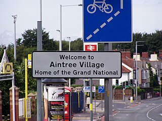
Aintree is a village and civil parish in the Metropolitan Borough of Sefton, Merseyside, England. Historically in Lancashire, it lies between Walton and Maghull on the A59 road, 5+1⁄2 miles northeast of Liverpool city centre, in North West England.

Orrell is a suburb of Wigan in the Metropolitan Borough of Wigan, Greater Manchester, England. The population of the ward had fallen at the 2011 Census to 11,513. The area lies 3 miles (4.8 km) to the west of Wigan town centre. The area is contiguous with Pemberton.

U.S. Route 431 (US 431), internally designated by the Alabama Department of Transportation (ALDOT) as State Route 1 (SR 1), is a major north–south state highway across the eastern part of the U.S. state of Alabama. Although US 431's south end is in Dothan, SR 1 continues south for about 13 miles (21 km) along US 231 to the Florida state line.

The A572 is a main road serving the Greater Manchester and Merseyside areas, running from Swinton to St Helens via Leigh and Newton-le-Willows.
The Route nationale 4 is a trunk road (nationale) in France between Paris and the frontier with Germany.

The A616 is a road that links Newark-on-Trent, Nottinghamshire, to the M1 motorway at Junction 30, then reappears at Junction 35A and goes on to Huddersfield, West Yorkshire.

The City of Peterborough in East Anglia has an extensive and well integrated road network, owing partly to its status as a new town. Since the 1960s, the city has seen considerable expansion and its various suburbs are linked by a system of parkways.

Lathom South is a civil parish in the West Lancashire district of Lancashire, England, situated near the towns of Ormskirk and Skelmersdale. The parish council was established in 2007, and the area, which includes the hamlets of Blaguegate and Scarth Hill, has historical ties to the neighbouring parish of Lathom. As of 2011, Lathom South has a population of 657.

State Route 85 is an east–west state highway in Middle Tennessee. The 83.4 miles (134.2 km)-long road traverses portions of Smith, Jackson, Overton, and Fentress Counties.
