
The Alabama River, in the U.S. state of Alabama, is formed by the Tallapoosa and Coosa rivers, which unite about 6 miles (10 km) north of Montgomery, near the town of Wetumpka.
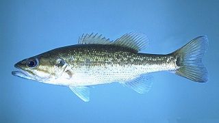
The spotted bass, also called spotty, or spots in various fishing communities, is a species of North American freshwater fish belonging to the sunfish family (Centrarchidae) of the order Perciformes. It is noted for the rows of dark spots below the lateral line, which give it its common name. One of the black basses, it is native to the Mississippi River basin and across the Gulf states, from central Texas through the Florida panhandle. Its native range extends into the western Mid-Atlantic states and it has been introduced into western North Carolina and Virginia. It has also been introduced to southern Africa, where it has become established in some isolated waters as an invasive species.

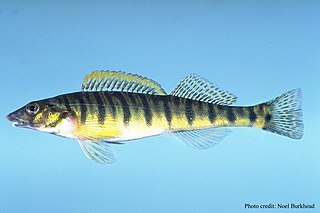
The redeye bass, redeye, or Coosa bass is a species of freshwater fish in the sunfish family (Centrarchidae) native to the Coosa River system of Georgia, Alabama. The waters it is normally found in are cool streams and rivers in the foothills of mountains.
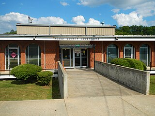
Heard County is a county located in the west central portion of the U.S. state of Georgia. At the 2020 census, the population was 11,412, down from 11,834 in 2010. The county seat is Franklin. The county was created on December 22, 1830.

The Ocmulgee River is a western tributary of the Altamaha River, approximately 255 mi (410 km) long, in the U.S. state of Georgia. It is the westernmost major tributary of the Altamaha. It was formerly known by its Hitchiti name of Ocheese Creek, from which the Creek (Muscogee) people derived their name.

The Coosa River is a tributary of the Alabama River in the U.S. states of Alabama and Georgia. The river is about 280 miles (450 km) long.

Lake Allatoona is a U.S. Army Corps of Engineers reservoir on the Etowah River in northwestern part of the State of Georgia. This reservoir is mostly in southeastern Bartow County and southwestern Cherokee County. A small portion is located in Cobb County near Acworth.

The Tallapoosa River runs 265 miles (426 km) from the southern end of the Appalachian Mountains in Georgia, United States, southward and westward into the Appalachian foothills in Alabama. It is formed by the confluence of McClendon Creek and Mud Creek in Paulding County, Georgia. Lake Martin at Dadeville, Alabama is a large and popular water recreation area formed by a dam on the river. The Tallapoosa joins the Coosa River about 10 miles (16 km) northeast of Montgomery near Wetumpka to form the Alabama River.

Lake Martin is located in Tallapoosa, Elmore and Coosa counties in Alabama. It is a 44,000-acre (178 km2) reservoir with over 750 miles (1,200 km) of wooded shoreline. Lake Martin is a reservoir, enlarged by the construction of Martin Dam on the Tallapoosa River. The Martin Dam powerhouse is used to generate hydroelectric power for the Alabama Power Company. Construction on Martin Dam began in 1923 and was completed in 1926, creating what was, at that time, the largest human-made body of water in the world. Originally known as Cherokee Bluffs for the geological formation upon which it was built, the dam was renamed in 1936 in honor of Thomas Martin, the then-president of Alabama Power Company. Alabama Power and Russell Lands own some of the shoreline.

Logan Martin Lake is a reservoir located in east central Alabama on the Coosa River approximately 30 miles (48 km) east of Birmingham, Alabama. This 17,000-acre (69 km2) reservoir was built in 1965 by Alabama Power Company. The lake, nicknamed Lake of a Thousand Coves by locals, has 275 miles (443 km) of shoreline along its 48.5-mile (78.1 km) length sandwiched between Logan Martin Dam on the south and Neely Henry Dam on the north. The depth of the lake is 35 to 110 feet (34 m) with only five feet average water level variance.

Alabama has a rich history and diversity of freshwater and saltwater sport fishing opportunities within its extensive rivers systems, farm ponds and the inshore and offshore saltwater of the Gulf of Mexico., The Bass Angler's Sportsman Society (B.A.S.S.), the leading promoter of competitive bass fishing was founded by Ray Scott in 1967 in Montgomery, Alabama. Alabama hosts numerous local, regional and national fishing tournaments every year.
Alabama supports 11 million angler fishing days with expenditures of three-quarters of a billion dollars, so join in the fun!

The trispot darter is a species of freshwater ray-finned fish, a darter from the subfamily Etheostomatinae, part of the family Percidae, which also contains the perches, ruffes and pikeperches. It is endemic to northern Georgia and southern Tennessee in the United States, where it occurs in the Conasauga River and its tributaries and historically in the Alabama River system. It requires two interconnecting habitats; outside the breeding season it occupies the peripheral zones of the main river, with slow-moving water and silt gravel substrates with vegetation cover; during the breeding season it moves to warmer water with a clay-bottomed substrate with much vegetation. The population of this fish is declining due to loss of suitable habitat because of stream impoundment and land development. The International Union for Conservation of Nature has assessed its conservation status as being "vulnerable".

Hamiota altilis, the finelined pocketbook, is a species of freshwater mussel, an aquatic bivalve mollusk in the family Unionidae, the river mussels.
Lake Wedowee, or R. L. Harris Reservoir, is a reservoir, located in Randolph County, Alabama on the upper part of the Tallapoosa River 90 miles (140 km) from Atlanta, Georgia. The lake has an area of 9,870 acres (39.9 km2). This lake was built at one of the last hydro sites in Alabama.
Weiss Lake in northeastern Alabama is owned and operated by the Alabama Power Company. At full summer pool, Weiss Lake sits 564 feet (172 m) above sea level. The lake covers 30,200 acres (122 km2) from the Coosa River, Chattooga River (Alabama–Georgia) and Little River, offering over 447 miles (719 km) of shoreline and shallow flats, large coves, under-water drop offs and deep channels. Weiss Lake also has privately owned hotels, marinas, campground and bait and tackle stores. There are 11 bridges that cross Weiss Lake.
Coosa River Basin Initiative (CRBI) is a 501(c)(3) grassroots environmental organization based in Rome, Georgia, with the mission of informing and empowering citizens to protect, preserve and restore North America's most biologically diverse river basin, the Coosa. Since 1992, the staff, board and members have served as advocates for "the wise stewardship of the natural resources of the Upper Coosa River basin, or watershed, which stretches from southeastern Tennessee and north central Georgia to Weiss Dam in Northeast Alabama. This includes the Coosa River, the Etowah and Oostanaula rivers and the tributaries of these waterways as well as the land drained by these streams and the air that surrounds this land area."

The tri-state water dispute is a 21st-century water-use conflict among the U.S. states of Georgia, Alabama, and Florida over flows in the Apalachicola-Chattahoochee-Flint River Basin and the Alabama-Coosa-Tallapoosa River Basin. The U.S. Army Corps of Engineers has regulated water flow for the entire Chattahoochee River, from Lake Lanier in Forsyth County, Georgia, to Alabama and Florida.
The Mobile logperch is a species of freshwater ray-finned fish, a darter from the subfamily Etheostomatinae, part of the family Percidae, which also contains the perches, ruffes and pikeperches. It is found in the Mobile River basin in Mississippi, Alabama, Tennessee, and Georgia in the southeastern United States. It inhabits clear shallow water and is often associated with Podostemum (riverweed). It grows to about 18 cm (7 in) and is distinguishable from other darters by the distinctive shape of its head and by its pale-yellow base color, with narrow bars on back and sides. It feeds on small invertebrates and breeds between February and May. Lake fish move into small streams to spawn. It is a common fish with a wide range and the International Union for Conservation of Nature has classified its conservation status as being of "least concern".
The bronze darter is a species of freshwater ray-finned fish, a darter from the subfamily Etheostomatinae, part of the family Percidae, which also contains the perches, ruffes and pikeperches. It is restricted to the Coosa and Tallapoosa River systems in Georgia, Alabama, and southeastern Tennessee in the United States. It feeds on insect larvae and other small invertebrates, and spawns in April and May. It is a common fish within its range and the International Union for Conservation of Nature has classified its conservation status as being of "least concern". However, it is susceptible to environmental disturbance and an ongoing management plan has been put in place to protect its habitat.
Florida v. Georgia, 585 U.S. ___ (2018), was a decision by the Supreme Court of the United States in an original jurisdiction case. It involves a long-running dispute over waters within the ACF River Basin, running from the north Georgia mountains through metro Atlanta to the Florida panhandle, which is managed by the United States Army Corps of Engineers. Waters in the area have been stressed by the population growth of Atlanta over previous decades. The immediate case stemmed from droughts in 2011 and 2012 that caused economic damage to Florida due to lower water flows from the ACF River Basin into the panhandle, impacting its seafood production; Florida sought relief to have more water allocated towards them from the ACF by placing a water allocation cap on Georgia. The Supreme Court assigned a special master to review Florida's complaint, but ultimately found in 2016 that Florida had not fully demonstrated the need for more allocation. Florida challenged this determination to the Supreme Court. On June 27, 2018, the Supreme Court ruled 5–4 that the special master had not properly considered Florida's argument and remanded the case to be reheard and reviewed.
